 |
Home Search OKRoads: |
|
|
Home Search OKRoads: |
Interstate 26
Interstate 26 is a diagonal interstate for the most part. It has seen a northward extension in the past two years.
The original Interstate 26 began at Interstate 40 in west Asheville, North Carolina, and went southeast into South Carolina through Spartanburg, Columbia, and Charleston, where the interstate ends at U.S. 17. In 2003, the interstate was extended northward along the U.S. 19/U.S. 23 corridor to Interstate 81 in Colonial Heights, Tennessee. The interstate was further extended in August 2005, when it took over the remaining Interstate 181 freeway north to the Virginia state line near Kingsport. We drove Interstate 26 less than a month before this extension, but we also drove all of Interstate 181, so technically, we have driven all of Interstate 26.
|
Highway Information |
|
| States Traveled
Through (Mileage in state) |
Tennessee (57) North Carolina (71.2) South Carolina (220.95) |
| Total Mileage | 349 |
| Note | The mileage figures given for Tennessee & North Carolina and the total mileage are approximations because the interstate has been extended since the last edition of the interstate route log was published. |
| Cities | Tennessee: Kingsport, Johnson City North
Carolina: South Carolina: |
| Source | 10/31/02 Interstate Route Log & Finder List |
| OKRoads Coverage | |
| Miles Driven by OKRoads (Percentage) |
349 (100%) |
| Western End of Interstate Driven |
Virginia State Line |
| Eastern End of Interstate Driven |
U.S. 17 |
Selected Pictures
For more pictures of Interstate 26 from a particular
state, click on the state below.
| Tennessee | |
 |
When this photo was taken, this was Interstate 181's northern terminus at Exit 55 - U.S. 11W/West Stone Drive. Now it is the next-to-last interchange on Interstate 26 West, with the extension of Interstate 26 over the remnant of Interstate 181 after Interstate 26 was first commissioned in Tennessee. (Photo taken 7/7/05) |
 |
The remnants of Tropical Storm Cindy made getting decent pictures a nearly impossible task on this early summer day. This is Interstate 26 West at Exit 46A - Interstate 81 North - Bristol, which was the western terminus of Interstate 26 at this time. (Photo taken 7/7/05) |
 |
Interstate 26 West at Exit 19 - Main Street/Erwin. This was a rare decent picture on this afternoon. (Photo taken 7/7/05) |
| North Carolina | |
 |
Interstate 26 West and U.S. 19 North at Exit 11 - North Carolina 213 - Mars Hill/Marshall. (Photo taken 7/7/05) |
 |
Interstate 26 and U.S. 74 West at Exit 31B - Interstate 40 and U.S. 74 West - Canton/Knoxville. After being duplexed with Interstate 26 for 36 miles, U.S. 74 heads to the west duplexed with Interstate 40 until Clyde (Exit 27). (Photo taken 7/7/05) |
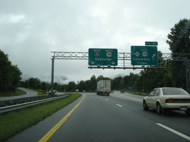 |
Interstate 26 West at Exit 67 - North Carolina 108 TO U.S. 74 East - Columbus/Tryon. Motorists must use North Carolina 108 to connect to U.S. 74 East. (Photo taken 7/7/05) |
| South Carolina | |
 |
Interstate 26 West at Exit 51 - Interstate 385 North - Laurens/Greenville. Interstate 385 connects Interstate 26 to the city of Greenville, 42 miles to the northwest. Laurens is accessible via either Exit 5 (South Carolina 49) or Exit 9 (U.S. 221). (Photo taken 7/7/05) |
 |
Interstate 26 and U.S. 76 West at Exit 107B - Interstate 20 East - Florence. The city marks Interstate 20's eastern terminus and is 85 miles to the east. (Photo taken 7/7/05) |
 |
Interstate 26 West at Exit 108B - Interstate 126 East - Columbia. Straight ahead on this collector/distributor ramp is Exit 108A for Bush River Road. To the left, the Interstate 26 mainline meets Interstate 20 in one-half mile. (Photo taken 7/7/05) |
 |
Interstate 26 West at Exit 116 - Interstate 77 North - Charlotte. The Queen City is a 103 mile drive from the southern terminus of Interstate 77. (Photo taken 7/7/05) |
 |
Believe it or not, this is an interchange between two interstates. This is Interstate 26 West at Exit 169B - Interstate 95 North - Florence. The sign bridge was down for some reason, so instead, the signage used along other intersecting highways at the interstate is in place. (Photo taken 7/7/05) |
 |
Interstate 26 West at Exit 212C - Interstate 526 East - Mount Pleasant. Interstate 526 is a half-loop around Charleston that connects to U.S. 17 at both ends. (Photo taken 7/7/05) |
Highway Links
Tennessee:
Interstate 26 Tennessee @ SouthEastRoads.com (Andy Field/Alex Nitzman)
North Carolina:
Interstate 26 North Carolina Eastbound @ SouthEastRoads.com (Andy Field/Alex Nitzman)
Interstate 26 North Carolina Westbound @ SouthEastRoads.com (Andy Field/Alex Nitzman)
South Carolina:
Interstate 26 South Carolina @ SouthEastRoads.com (Andy Field/Alex Nitzman)
Page created: November 29, 2005
Last updated:
December 01, 2005