 |
Home Search OKRoads: |
|
|
Home Search OKRoads: |
Interstate 86 New York
Eastbound - Pennsylvania State Line to
Almond
|
Highway Information |
|
| Miles | 176.57 |
| Counties Traveled Through |
Chautauqua, Cattaraugus, Allegany, Steuben, Chemung |
| Cities |
Jamestown, Salamanca, Olean, Hornell, Corning |
| Major Junctions | Interstate 390 (Exit 36) |
| OKRoads Coverage | |
| Miles Driven by OKRoads (Percentage) |
177 (100%) |
| Western End of Interstate Driven |
Pennsylvania State Line |
| Eastern End of Interstate Driven |
New York 14 |
Pictures
Eastbound:
Pennsylvania State Line to Almond
| Interstate 86 and New York 17 East | |
 |
Welcome to New York sign as Interstate 86 enters the Empire State. This was the first time we were ever in New York. (Photo taken 7/8/05) |
 |
Interstate 86 and New York 17 East duplex throughout all of the interstate's mileage in the state. The interstate is also called the Southern Tier Expressway. The first exit is Exit 4, New York 426, 3/4 mile. New York uses sequential exit numbers, but the first exit is Exit 4. A likely reason is that the last Pennsylvania exit is Exit 3, and 4 comes right after 3. (Photo taken 7/8/05) |
 |
Interstate 86 and New York 17 East at Exit 4 - New York 426 - Findley Lake. Five miles to the south is the Peek'n Peak Resort and Conference Center. (Photo taken 7/8/05) |
 |
Interstate 86, New York 17, and Southern Tier Expressway shields just past Exit 4. New York 17 will be decommissioned along Interstate 86 when the interstate is fully completed around the year 2010. (Photo taken 7/8/05) |
 |
Mileage sign on Interstate 86 and New York 17 East after New York 426. Jamestown is 26 miles ahead, while Binghamton is 245 miles ahead via New York 17. Interstate 86 ends at New York 14 in Horseheads in 182 miles. (Photo 7/8/05) |
 |
Interstate 86 and New York 17 East approaching Exit 6 - New York 76 - 1 mile. The state highway spans 19.4 miles from New York 474 in North Clymer to New York 5 in Ripley. (Photo taken 7/8/05) |
 |
Interstate 86 and New York 17 East at Exit 6 - New York 76 - Sherman. The town of 1,553 residents is just to the north. (Photo taken 7/8/05) |
 |
Interstate 86 and New York 17 East approaching Exit 7 - Chautauqua County 33 - 1 mile. Chautauqua County 33 goes south six miles to New York 474 in the village of Panama. To the north four miles is the town of Chautauqua and the Chautauqua Institution. The Chautauqua Institution includes golf, tennis, and performance venues. (Photo taken 7/8/05) |
 |
Interstate 86 and New York 17 East at Exit 7 - Chautauqua County 33 - Panama/Chautauqua Institution. If mileage-based exit numbers were used in New York, this would be Exit 15. (Photo taken 7/8/05) |
 |
Interstate 86 and New York 17 East approaching Exit 8 - New York 394 - 1 mile. New York 394 begins at Interstate 86's Exit 17 and heads west close to the Southern Tier Expressway between Jamestown and Steamburg. From Jamestown to Mayville, the state highway runs along the southern and western shore of Chautauqua Lake. New York 394 finds its western terminus at New York 5 in Barcelona. (Photo taken 7/8/05) |
 |
Interstate 86 and New York 17 East at Exit 8 - New York 394 - Mayville/Lakewood. Exit 13 of the Southern Tier Expressway also serves the state highway. (Photo taken 7/8/05) |
 |
Interstate 86 and New York 17 East approaching the first rest area - 2 1/2 miles. The interstate crosses Chautauqua Lake ahead. (Photo taken 7/8/05) |
 |
Interstate 86 and New York 17 East cross Chautauqua Lake on the Chautauqua County Veterans Memorial Bridge. The bridge is about 2/3 mile long. (Photo taken 7/8/05) |
 |
Interstate 86 and New York 17 East approaching Exit 9 - New York 430 East - 1/2 mile, and Exit 10 - New York 430 West - 3/4 mile. Both signs use all-text instead of assurance shields for the state highway. (Photo taken 7/8/05) |
 |
Interstate 86 and New York 17 East at Exit 9 - New York 430 East - Bemus Point. Access to westbound is provided by the next exit, a left exit onto a short freeway spur between New York 430 and the Southern Tier Expressway. (Photo taken 7/8/05) |
 |
Interstate 86 and New York 17 East at Exit 10 - To New York 430 West. The freeway extends northwest for two miles before it transitions into a two-lane road. New York 430 is 1.2 mile to the northwest of this interchange. (Photo taken 7/8/05) |
 |
Interstate 86 and New York 17 East approaching the Chautauqua County rest area - 1 mile. The next rest area after this one is 19 miles ahead in western Cattaraugus County. (Photo taken 7/8/05) |
 |
Pull-through panel on Interstate 86 and New York 17 East as the left lane, which comes in from the New York 430 spur, prepares to end in 700 feet. (Photo taken 7/8/05) |
 |
Interstate 86 and New York 17 East at the Chautauqua County rest area. Tourist information is available at the rest area. (Photo taken 7/8/05) |
 |
Interstate 86 and New York 17 East approaching Exit 11 - Strunk Road - 1 mile. Strunk Road is 2.4 miles long from New York 430 to Chautauqua County 120 near the Chautauqua County/Jamestown Airport. Motorists are requested to use Exit 12 (New York 60) to the airport. (Photo taken 7/8/05) |
 |
Interstate 86 and New York 17 East at Exit 11 - Strunk Road. (Photo taken 7/8/05) |
 |
Interstate 86 and New York 17 East approaching Exit 12 - New York 60 - 3/4 mile. New York 60 provides the main access into the city of Jamestown, population 31,730. The state highway enters the city on Main Street. (Photo taken 7/8/05) |
 |
Use New York 60 north to the Chautauqua County and Jamestown Airport. Or, as previously stated, Strunk Road northbound can also be used. (Photo taken 7/8/05) |
 |
The campus of Jamestown Community College is located near Interstate 86 between exits 12 and 13. Use New York 60 south to the community college that is part of the State University of New York. (Photo taken 7/8/05) |
 |
Interstate 86 and New York 17 East at Exit 12 - New York 60 - Jamestown. Oak Hill Road crosses the interstate prior to the exit ramp departure. (Photo taken 7/8/05) |
 |
Interstate 86 and New York 17 East approaching Exit 13 - New York 394 - 1 mile. The trumpet interchange leads to the state highway just south of the interstate. The village of Falconer (pop. 2,540) is to the southwest of the upcoming interchange. (Photo taken 7/8/05) |
 |
Interstate 86 and New York 17 East at Exit 13 - New York 394 - Falconer. Interstate 86/New York 17 and New York 394 will meet for the 3rd and final time in 17 miles at Exit 17. (Photo taken 7/8/05) |
 |
Interstate 86 and New York 17 East approaching Exit 14 - U.S. 62 - 1 mile. U.S. 62 is a north-south highway in Pennsylvania and New York, but is east-west for the rest of its journey to the Mexico border in El Paso, Texas. The federal highway meets its northern terminus in downtown Niagara Falls. New York 394 goes underneath the interstate just ahead. (Photo taken 7/8/05) |
 |
Interstate 86 and New York 17 East at Exit 14 - U.S. 62 - Kennedy/Warren PA. A 28 mile drive separates this folded diamond interchange from Warren, Pennsylvania. (Photo taken 7/8/05) |
 |
Interstate 86 and New York 17 East approaching Exit 15 - School House Road - 1 mile. School House Road is a short connector between Main Street Road and New York 394. This is the first eastbound exit in Cattaraugus County. (Photo taken 7/8/05) |
 |
Interstate 86 and New York 17 East approaching the Cattaraugus County rest area - 2 miles. No restroom facilities are available at this rest area. (Photo taken 7/8/05) |
 |
Interstate 86 and New York 17 East at Exit 15 - School House Road. (Photo taken 7/8/05) |
 |
Interstate 86 and New York 17 East approaching the Cattaraugus County rest area - 1 mile. After this one, there are no rest areas until eastern Steuben County between exits 40 and 41. (Photo taken 7/8/05) |
 |
Interstate 86 and New York 17 East approaching the Cattaraugus County rest area - 1/2 mile. Again, there are no restroom facilities here. (Photo taken 7/8/05) |
 |
Interstate 86 and New York 17 East approaching Exit 16 - West Main Street - 1 mile. The town of Randolph has a population of 2,681, and is just east of Exit 16. (Photo taken 7/8/05) |
 |
Interstate 86 and New York 17 East at the Cattaraugus County rest area. (Photo taken 7/8/05) |
 |
Use Exit 16 to the Cattaraugus County Fairgrounds. The fairgrounds is in Little Valley, which is 13 miles to the northeast via Main Street, New York 394, and New York 242. (Photo taken 7/8/05) |
 |
Interstate 86 and New York 17 East at Exit 16 - West Main Street - Randolph/Gowanda. (Photo taken 7/8/05) |
 |
Interstate 86 and New York 17 East approaching Exit 17 - New York 394 - 1 mile. The diamond interchange marks the eastern terminus of the state highway. (Photo taken 7/8/05) |
 |
Continue to Exit 18 (New York 280) to the Kinzua Dam & Allegheny Reservoir. The reservoir spans the Pennsylvania-New York state line. (Photo taken 7/8/05) |
 |
Interstate 86 and New York 17 East at Exit 17 - New York 394 - Steamburg/Onoville. (Photo taken 7/8/05) |
 |
Interstate 86 and New York 17 East enter the Seneca Nation of Indians territory immediately after Exit 17. Some signs off of the interstate inside the Seneca territory are in both English and Seneca languages. (Photo taken 7/8/05) |
 |
Use either Exit 18 (New York 280) or Exit 19 to the Allegany State Park. The park covers 65,000 acres in southern Cattaraugus County. (Photo taken 7/8/05) |
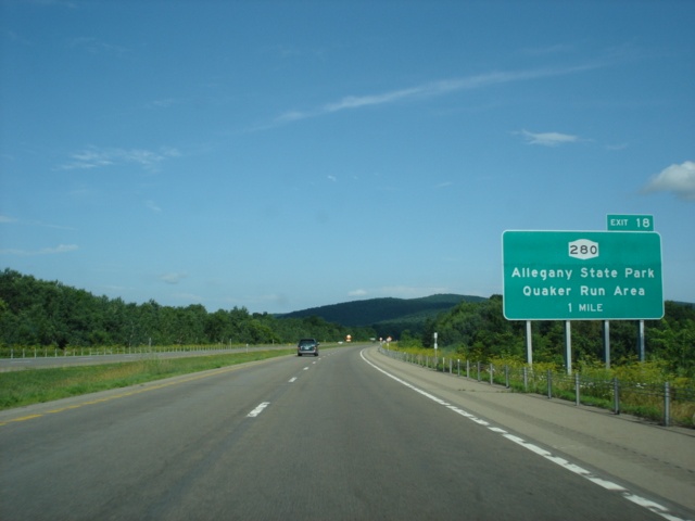 |
Interstate 86 and New York 17 East approaching Exit 18 - New York 280 - 1 mile. The state highway begins at Exit 18 and goes south along the eastern shore of the Allegheny Reservoir to the Pennsylvania state line, where the highway becomes Pennsylvania 346. (Photo taken 7/8/05) |
 |
As another sign mentioned prior to Exit 17, New York 280 can be used to the Kinzua area of Pennsylvania and New York. (Photo taken 7/8/05) |
 |
Interstate 86 and New York 17 East at Exit 18 - New York 280 - Allegany State Park/Quaker Run Area. (Photo taken 7/8/05) |
 |
Interstate 86 and New York 17 East approaching Exit 19 - Jimmerstown Road/State Park Route 2 - 1 mile. State Park Route 2 leads to the Red House Area of the Allegany State Park. (Photo taken 7/8/05) |
 |
Interstate 86 and New York 17 East at Exit 19 - Jimmerstown Road/State Park Route 2 - Allegany State Park/Red House Area. (Photo taken 7/8/05) |
 |
Interstate 86 and New York 17 East approaching Exit 20 - New York 417 and New York 353 - 1 mile. This marks the western terminus of New York 417, which is the original route of New York 17 between Salamanca and U.S. 15 in Gang Mills. Use New York 417 east to the southern terminus of New York 353, which goes northward to U.S. 62 in Dayton. (Photo taken 7/8/05) |
 |
Use New York 417 east and New York 353 north to the Cattaraugus County Fairgrounds in Little Valley. (Photo taken 7/8/05) |
 |
The city of Salamanca (population 6,097) is home to the Salamanca Rail Museum and the Seneca-Iroquois National Museum. (Photo taken 7/8/05) |
 |
The Seneca Nation operates a casino just south of Exit 20. The Seneca Allegany Casino stands out at the diamond interchange. (Photo taken 7/8/05) |
 |
Interstate 86 and New York 17 East at Exit 20 - New York 417 and New York 353 - Salamanca. The aforementioned casino is visible behind the Exit 20 BGS. (Photo taken 7/8/05) |
 |
Interstate 86 and New York 17 East approaching Exit 21 - U.S. 219 North - 1 mile. U.S. 219 and the Southern Tier Expressway closely parallel each other between exits 21 and 23. Exit 21 directly serves Fairmount Avenue, which connects to Parkway Drive (a north-south arterial one block east of Fairmont) and New York 417. Take New York 417 east to U.S. 219 North. (Photo taken 7/8/05) |
 |
Use U.S. 219 North to Ellicottville, located in central Cattaraugus County. The town is 12 miles to the north. (Photo taken 7/8/05) |
 |
Interstate 86 and New York 17 East at Exit 21 - U.S. 219 North - Parkway Drive/Salamanca/Ellicottville. (Photo taken 7/8/05) |
 |
Interstate 86 and New York 17 East approaching Exit 23 - U.S. 219 South - 1 mile. There is no Exit 22 in either direction of the Southern Tier Expressway. (Photo taken 7/8/05) |
 |
Use Exit 23 to the New York State Division for Youth Cattaraugus County Residential Center. (Photo taken 7/8/05) |
 |
Interstate 86 and New York 17 East at Exit 23 - U.S. 219 South - Limestone/Bradford PA. Access to both directions of the federal highway is available from this off-ramp. Limestone is five miles to the south, and Bradford is nine miles away. U.S. 219 becomes a freeway soon after entering Pennsylvania 6 1/2 miles south of Exit 23. (Photo taken 7/8/05) |
 |
Interstate 86 and New York 17 East approaching Exit 24 - New York 417 - 1 mile. St. Bonaventure University is located on the state highway between Allegany and Olean. The Catholic university was founded in 1858 by the Franciscan Friars and today has an enrollment of 2,200 undergraduate students. Interstate 86 and New York 17 cross over the Allegheny River and New York 417 just ahead. (Photo taken 7/8/05) |
 |
Interstate 86 and New York 17 East at Exit 24 - New York 417 - Allegany/St. Bonaventure University. A short jog south on Five Mile Road is necessary to make the connection to New York 417. (Photo taken 7/8/05) |
 |
Interstate 86 and New York 17 East approaching Exit 25 - Buffalo Street - 1 mile. Exit 25 is one of two exits to directly serve the city of Olean, population 15,347. Buffalo Street is a diagonal street from northwest to southeast and stands out in the county's largest city that uses a grid pattern for most of its streets. (Photo taken 7/8/05) |
 |
One of three regional New York State Police forensics labs is located in Olean. Use Buffalo Street to the lab. (Photo taken 7/8/05) |
 |
Interstate 86 and New York 17 East at Exit 25 - Buffalo Street/Olean. (Photo taken 7/8/05) |
 |
Interstate 86 and New York 17 East approaching Exit 26 - New York 16 - 1 mile. New York 16 spans 79 miles from the Pennsylvania state line to New York 5 in Buffalo. (Photo taken 7/8/05) |
 |
Use New York 16 to the Cattaraugus Campus of Jamestown Community College. Also in Olean is the Olean Business Institute. (Photo taken 7/8/05) |
 |
Interstate 86 and New York 17 East at Exit 26 - New York 16 - Olean. A trumpet interchange is in use here for the connection to the state highway, which parallels the interstate between exits 26 and 27, a distance of five miles. (Photo taken 7/8/05) |
 |
Interstate 86 and New York 17 East approaching Exit 27 - New York 16/New York 446 - 1 mile. New York 446 begins less than one-half mile north of Exit 27 and goes east to New York 305 in Cuba. Overall, New York 446 is 6.8 miles long. (Photo taken 7/8/05) |
 |
Interstate 86 and New York 17 East at Exit 27 - New York 16/New York 446 - Hinsdale. The town is just south of Exit 27. (Photo taken 7/8/05) |
 |
Interstate 86 and New York 17 East prepare to enter Allegany County as the Southern Tier Expressway approaches Exit 28 - New York 305 - 1 mile. (Photo taken 7/8/05) |
 |
Interstate 86 and New York 17 East at Exit 28 - New York 305 - Cuba. The state highway extends 31.4 miles from the Pennsylvania state line to New York 19 in Belfast. (Photo taken 7/8/05) |
 |
Interstate 86 and New York 17 East approaching Exit 29 - New York 275 - 1 mile. New York 275 is a short 11.3-mile north-south highway between Interstate 86/New York 17 and New York 417 in Bolivar. (Photo taken 7/8/05) |
 |
Interstate 86 and New York 17 East at Exit 29 - New York 275 - Friendship/Bolivar. The town of Friendship is home to 1,927 and is immediately south of this exit. (Photo taken 7/8/05) |
 |
Interstate 86 and New York 17 was in the midst of a resurfacing project between exits 29 and 30 in July 2005. The speed limit was signed at 55 as all traffic utilized the westbound lanes. (Photo taken 7/8/05) |
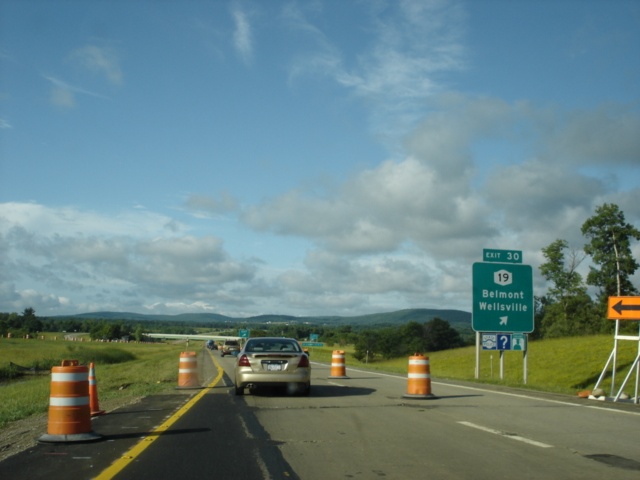 |
Interstate 86 and New York 17 East at Exit 30 - New York 19 - Belmont/Wellsville. The work zone ended just in time for this exit. New York 19 is a lengthy north-south state highway from the Pennsylvania state line to the Lake Ontario State Parkway. Belmont, the seat of Allegany County, is three miles to the south. (Photo taken 7/8/05) |
 |
Interstate 86 and New York 17 East approaching Exit 31 - Angelica - 1 mile. The town is home to 1,411 and the village is home to 903. (Photo taken 7/8/05) |
 |
Use Exit 31 to the Allegany County Fairgrounds, located in Angelica. (Photo taken 7/8/05) |
 |
Interstate 86 and New York 17 East at Exit 31 - Angelica. Take Peacock Hill Road north to the town. (Photo taken 7/8/05) |
 |
Interstate 86 and New York 17 East approaching Exit 32 - Karr Valley Road - 1 mile. Just southwest of Exit 32 is the town of West Almond, population 353. (Photo taken 7/8/05) |
 |
Interstate 86 and New York 17 East at Exit 32 - Karr Valley Road - West Almond. (Photo taken 7/8/05) |
 |
Between exits 32 and 33, Interstate 86 reaches its highest elevation along its 177-mile route through southwest New York. The point is marked with this sign, 2,110 feet above sea level. (Photo taken 7/8/05) |
 |
Interstate 86 and New York 17 East approaching Exit 33 - New York 21 - 1 mile. New York 21 begins at New York 417 in Andover 13 miles to the south of Exit 33. The highway meets its northern terminus at New York 104 in Williamson near Lake Ontario. (Photo taken 7/8/05) |
 |
Between Almond and Andover lies the town and village of Alfred, home to Alfred State College and Alfred University. Alfred State College has an enrollment of about 3,000 students and is one of five University Colleges of Technology within the State University of New York system. Alfred University is home to the only New York State College of Ceramics not at Cornell University. (Photo taken 7/8/05) |
 |
Interstate 86 and New York 17 East at Exit 33 - New York 21 - Almond/Andover/Alfred. Within the next mile, motorists will enter Steuben County. Exit 33 connects to Karr Valley Road (the same road we saw back at Exit 32), which is then used to make the connection to the state highway. New York 21 never directly connects with the Southern Tier Expressway; from Almond, the state highway heads more easterly than Interstate 86 to Hornell, then passes by Interstate 86 east of the Exit 34 interchange at New York 36. (Photo taken 7/8/05) |
Page created: January 02, 2006
Last updated:
January 04, 2006