 |
Home Search OKRoads: |
|
|
Home Search OKRoads: |
Hardy Toll Road
The Hardy Toll Road is owned and operated by the Harris County Toll Authority. It is 21 miles long at the present time and connects Interstate 610, the Sam Houston Parkway, and Interstate 45. Future plans call for an extension southward to downtown Houston.
Pictures
| Northbound | |
 |
Hardy Toll Road North approaching Crosstimbers Rd. Motorists who may have accidentally got on the toll road from Interstate 610 are given one final opportunity to exit before paying toll. (Photo taken 3/16/05) |
 |
Hardy Toll Road North at Crosstimbers Rd. The next exit is about one mile ahead. (Photo taken 3/16/05) |
 |
Hardy Toll Road North approaching Tidwell Rd./Parker Rd. - 1 mile. (Photo taken 3/16/05) |
 |
Hardy Toll Road North approaching Tidwell Rd./Parker Rd. - 1/4 mile. Most of the toll road between here and the Sam Houston Parkway looks much like this scene here, with a railroad track in the median and small urban housing on the other side of the shoulder. (Photo taken 3/16/05) |
 |
Mileage sign on the Hardy Toll Road North near the Tidwell Rd. interchange. Spring is 19 miles away, and The Woodlands are 24 miles away. Both Houston suburbs are accessible via Interstate 45 North. (Photo taken 3/16/05) |
 |
Hardy Toll Road North at Tidwell Rd./Parker Rd. (Photo taken 3/16/05) |
 |
Hardy Toll Road North approaching Little York Rd./Gulf Bank Rd. - 1 1/2 miles. (Photo taken 3/16/05) |
 |
Hardy Toll Road North approaching Little York Rd./Gulf Bank Rd. - 1 mile. (Photo taken 3/16/05) |
 |
Hardy Toll Road North approaching Little York Rd./Gulf Bank Rd. - 1/4 mile. (Photo taken 3/16/05) |
 |
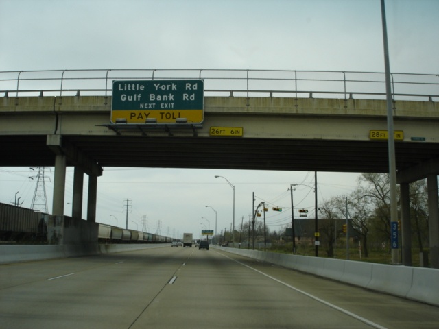
Hardy Toll Road North at Little York Rd./Gulf Bank Rd. (Photo taken 3/16/05) |
 |
Hardy Toll Road North approaching Aldine-Mail Rd./Aldine-Bender Rd. - 1 3/4 miles. (Photo taken 3/16/05) |
 |
Hardy Toll Road North approaching Aldine-Mail Rd./Aldine-Bender Rd. - 1 mile. (Photo taken 3/16/05) |
 |
Hardy Toll Road North approaching Aldine-Mail Rd./Aldine-Bender Rd. - 1/4 mile. (Photo taken 3/16/05) |
 |
Hardy Toll Road North at Aldine-Mail Rd./Aldine-Bender Rd. Aldine-Bender Rd. is also signed as Spur 525. (Photo taken 3/16/05) |
 |
Trucks, trailers, and buses are advised to use the right lane at the toll plaza, located two miles ahead from this overpass that carries Aldine-Mail Rd. over the toll road. (Photo taken 3/16/05) |
 |
Hardy Toll Road North approaching Beltway 8/Sam Houston Parkway - 2 miles. (Photo taken 3/16/05) |
 |
EZTag customers use the left lane at the toll plaza, much like most other toll plazas in the country. (Photo taken 3/16/05) |
 |
Hardy Toll Road North approaching Beltway 8 - 1 mile. (Photo taken 3/16/05) |
 |
Hardy Toll Road North at the toll plaza and the split of the EZTag and cash lanes. (Photo taken 3/16/05) |
 |
The southern toll plaza of the Hardy Toll Road. (Photo taken 3/16/05) |
 |
Hardy Toll Road North at Beltway 8 - Sam Houston Parkway. (Photo taken 3/16/05) |
| Southbound | |
 |
After leaving Interstate 45 behind, motorists are welcomed to the Hardy Toll Road by this sign. The toll road is 21 miles long with a speed limit of 60 throughout. (Photo taken 3/16/05) |
 |
Hardy Toll Road South approaching the north toll plaza. This is what a typical section of the toll road north of Beltway 8 looks like. (Photo taken 3/16/05) |
 |
Again, EZTag customers are advised to use the left lane at the toll plaza. (Photo taken 3/16/05) |
 |
Remember, there are cameras watching if one decides to go through the EZTag lanes and they do not have one! (Photo taken 3/16/05) |
 |
Hardy Toll Road South at the split of the EZTag and cash lanes at the north toll plaza. (Photo taken 3/16/05) |
 |
The north toll plaza of the Hardy Toll Road. (Photo taken 3/16/05) |
 |
Hardy Toll Road South approaching FM 1960 - 1 1/4 miles. The yellow diamond sign to the right warns of limited sight distance in this vicinity. (Photo taken 3/16/05) |
 |
Hardy Toll Road South approaching FM 1960 - 1/2 mile. (Photo taken 3/16/05) |
 |
Hardy Toll Road South at FM 1960. FM 1960 runs along the western and northern edges of the Houston metropolitan area and connects the suburbs of Addicks and Humble. (Photo taken 3/16/05) |
 |
Hardy Toll Road South approaching Richey Rd./East Hardy St. - 1 mile. (Photo taken 3/16/05) |
 |
Hardy Toll Road South approaching Richey Rd./East Hardy St. - 1/2 mile. Hardy St. runs parallel to the toll road for most of its length. (Photo taken 3/16/05) |
 |
Hardy Toll Road South at Richey Rd./East Hardy St. (Photo taken 3/16/05) |
 |
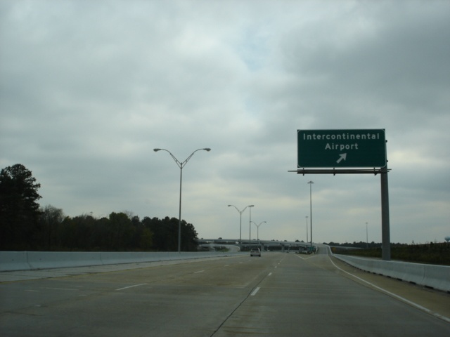
Hardy Toll Road South 1 1/2 miles north of the connector to the George Bush Intercontinental Airport. The connector between the toll road and the airport was completed in 2000. (Photo taken 3/16/05) |
 |
Hardy Toll Road South approaching Rankin Rd. - 1 mile. The toll road leaves the railroad right-of-way for a short stretch near the airport. (Photo taken 3/16/05) |
 |
Hardy Toll Road South approaching Rankin Rd. - 1/2 mile. (Photo taken 3/16/05) |
 |
Hardy Toll Road South approaching Beltway 8/Sam Houston Parkway - 1 3/4 miles. (Photo taken 3/16/05) |
 |
Hardy Toll Road South at Rankin Rd. (Photo taken 3/16/05) |
 |
Hardy Toll Road South at the Intercontinental Airport connector. Beltway 8 is one mile ahead. (Photo taken 3/16/05) |
 |
Hardy Toll Road South approaching Beltway 8 - 3/4 mile. With the exception of a direct connector from Beltway 8 East to Hardy Toll Road North, all connections between the toll road and the beltway are between the feeder roads. (Photo taken 3/16/05) |
 |
Hardy Toll Road South at Beltway 8/Sam Houston Parkway. The south toll plaza is less than a mile away. (Photo taken 3/16/05) |
 |
As Aldine-Bender Rd. goes over the toll road, the EZTag and all other payment lanes split. (Photo taken 3/16/05) |
 |
It is time once again to donate to the Harris County Toll Road Authority. For a 2-axle vehicle, the toll is $1.25 without an EZTag, and $1 with an EZTag. (Photo taken 3/16/05) |
 |
Hardy Toll Road South approaching Aldine-Mail Rd./Gulf Bank Rd. - 1 mile. (Photo taken 3/16/05) |
 |
Hardy Toll Road South approaching Aldine-Mail Rd./Gulf Bank Rd. - 1/2 mile. (Photo taken 3/16/05) |
 |
Hardy Toll Road South at Aldine-Mail Rd./Gulf Bank Rd. I predict that this button copy relic will be replaced in the near future. (Photo taken 3/16/05) |
 |
Mileage sign on Hardy Toll Road South as we head underneath Aldine-Mail Rd. Little York Rd. is the next interchange 1 3/4 miles ahead. (Photo taken 3/16/05) |
 |
Three-quarters of a mile later, another mileage sign as the toll road goes past Gulf Bank Rd. (Photo taken 3/16/05) |
 |
Berry Rd. gets added to this mileage sign in advance of the Little York Rd. exit, now one-half mile away. (Photo taken 3/16/05) |
 |
Hardy Toll Road South at Little York Rd. (Photo taken 3/16/05) |
 |
Hardy Toll Road South approaching Parker Rd./Tidwell Rd./Berry Rd. - 1/2 mile. All three are east-west arterials serving north Houston. (Photo taken 3/16/05) |
 |
Hardy Toll Road South at Parker Rd./Tidwell Rd./Berry Rd. (Photo taken 3/16/05) |
 |
Hardy Toll Road South approaching Crosstimbers Rd. - 1 3/4 miles. Parker Rd. crosses over the toll road 26 feet above us. (Photo taken 3/16/05) |
 |
Hardy Toll Road South approaching Crosstimbers Rd. - 3/4 mile. This overpass carries Tidwell Rd. (Photo taken 3/16/05) |
 |
Hardy Toll Road South approaching Interstate 610 - 2 miles. Until the Hardy Toll Road is extended to downtown, motorists are advised to use U.S. 59 South into downtown Houston. U.S. 59 intersects Interstate 610 within a mile of the Hardy Toll Road. (Photo taken 3/16/05) |
 |
Hardy Toll Road South at Crosstimbers Rd. (Photo taken 3/16/05) |
 |
Hardy Toll Road South approaching Interstate 610 - 1 mile. (Photo taken 3/16/05) |
 |
Hardy Toll Road South approaching Interstate 610 - 1/4 mile. The highway widens to four lanes in anticipation of the stack interchange. (Photo taken 3/16/05) |
 |
Hardy Toll Road South at Interstate 610 West/Hardy St. The two left lanes continue to Interstate 610 East and U.S. 59. (Photo taken 3/16/05) |
 |
Finally, Hardy Toll Road South at Interstate 610 West. Hardy St. continues to its end less than a mile shy of downtown Houston and Interstate 10. (Photo taken 3/16/05) |
Selected Links
Harris County Toll Road Authority
Hardy Toll Road Rates:
Southern Section |
Northern Section
Hardy Toll Road @ TexasFreeway.com (Erik Slotboom/Ron Jackson)
Page created: June 04, 2005
Last updated:
June 04, 2005