 |
Home Search OKRoads: |
|
|
Home Search OKRoads: |
Interstate 10 Florida
|
Highway Information |
|
| Miles | 362.28 |
| Counties Traveled Through |
Escambia, Santa Rosa, Okaloosa, Walton, Holmes, Washington, Jackson, Gadsden, Leon, Jefferson, Madison, Suwannee, Columbia, Baker, Nassau, Duval |
| Cities | Pensacola, Tallahassee, Jacksonville |
| Major Junctions | Interstate 110 (Exit 12)
Interstate 75 Interstate 295 Interstate 95 |
| OKRoads Coverage | |
| Miles Driven by OKRoads (Percentage) |
296 (81.8%) |
| Western End of Interstate Driven |
Alabama State Line |
| Eastern End of Interstate Driven |
Interstate 75 South (Exit 296A) |
Pictures
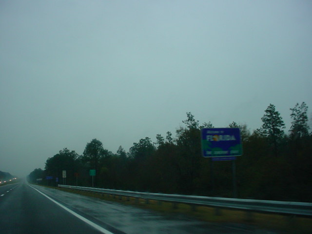 |
"Welcome to Florida" sign on
Interstate 10 East as the freeway enters its final state. The sign also says that this is the Sunshine State. Well, my question on this day was, where is it? (Photo taken 12/13/03) |
 |
Interstate 10 East at Exit 5 - ALT
U.S. 90. (Photo taken 12/13/03) |
 |
Interstate 10 East at Exit 7A - FL
297 South - Pine Forest Road/Pensacola N.A.S. These signs look more like they belong in Georgia, as they use the same font that the Peach State uses. Also notice that Exit 7B is 1/5 mile ahead. (Photo taken 12/13/03) |
 |
Interstate 10 East at Exit 7B - FL
297 North - Pine Forest Road. (Photo taken 12/13/03) |
 |
Interstate 10 East at Exit 10A -
U.S. 29 South - Pensacola. (Photo taken 12/13/03) |
 |
Interstate 10 East at Exit 10B -
U.S. 29 North - Cantonment. Interstate 110 is 2 miles ahead. (Photo taken 12/13/03) |
 |
Interstate 10 East approaching Exit 12 - Interstate 110 - 1 mile. (Photo taken 12/13/03) |
 |
Interstate 10 East at Exit 12 -
Interstate 110 - Pensacola/Pensacola Beach. This interchange is undergoing some major construction. For more information, visit the Florida DOT website for the project. (Photo taken 12/13/03) |
 |
Interstate 10 East at Exit 13 - FL
291 - Pensacola/University of West Florida. (Photo taken 12/13/03) |
 |
Interstate 10 East at
Exit 17 - U.S. 90. The Escambia Bay is just ahead. (Photo taken 12/14/03) |
 |
Interstate 10 East as it
prepares to go over Escambia Bay. (Photo taken 12/14/03) |
 |
Interstate 10 East on
the Escambia Bay bridge. Both spans of this bridge were heavily damaged during Hurricane Ivan which hit September 15, 2004. (Photo taken 12/14/03) |
 |
Interstate 10 East at
Exit 22 - FL 281 North/FL Toll 281 South - Milton/Gulf Breeze. (Photo taken 12/14/03) |
 |
Interstate 10 East at
Exit 26 - CR 191 - Milton/Bagdad. (Photo taken 12/14/03) |
 |
Interstate 10 East at
Exit 28 - CR 89 - Milton. (Photo taken 12/14/03) |
 |
Interstate 10 East at
Exit 31 - FL 87 - Ft. Walton Beach/Navarre. (Photo taken 12/14/03) |
 |
Interstate 10 East at
Exit 45 - CR 189 - Holt. (Photo taken 12/14/03) |
 |
Interstate 10 East at
Exit 56 - FL 85 - Crestview/Niceville. (Photo taken 12/14/03) |
 |
Interstate 10 East at
Exit 70 - FL 285 - Niceville/Eglin AFB. (Photo taken 12/14/03) |
 |
Interstate 10 East at
Exit 85 - U.S. 331 - DeFuniak Springs/Freeport. (Photo taken 12/14/03) |
 |
Interstate 10 East at
Exit 96 - FL 81 - Ponce De Leon. (Photo taken 12/14/03) |
 |
Interstate 10 East at
Exit 104 - CR 279 - Caryville. (Photo taken 12/14/03) |
 |
Interstate 10 East at
Exit 112 - FL 79 - Bonifay/Panama City Beach. (Photo taken 12/14/03) |
 |
Interstate 10 East at
Exit 120 - FL 77 - Chipley/Panama City. (Photo taken 12/14/03) |
 |
Interstate 10 East at
Exit 130 - U.S. 231 - Cottondale/Panama City. (Photo taken 12/14/03) |
 |
Interstate 10 East at
Exit 136 - FL 276 - Marianna. (Photo taken 12/14/03) |
 |
Interstate 10 East at
Exit 142 - FL 71 - Marianna/Blountstown. (Photo taken 12/14/03) |
 |
Interstate 10 East at
Exit 158 - CR 286 - Sneads. (Photo taken 12/14/03) |
 |
Interstate 10 East as it
enters Gadsden County and the Eastern Time Zone. (Photo taken 12/14/03) |
 |
Interstate 10 East at
Exit 166 - CR 270A - Chattahoochee. (Photo taken 12/14/03) |
 |
Interstate 10 East at
Exit 174 - FL 12 - Quincy/Greensboro. (Photo taken 12/14/03) |
 |
Interstate 10 East at
Exit 181 - FL 267 - Quincy. (Photo taken 12/14/03) |
 |
Interstate 10 East at
Exit 192 - U.S. 90 - Quincy/Tallahassee. (Photo taken 12/14/03) |
 |
Interstate 10 East at
Exit 196 - FL 263 - Capital Circle Regional Airport. (Photo taken 12/14/03) |
 |
Interstate 10 East at
Exit 203 - U.S. 319/ FL 61 - Tallahassee/Thomasville. (Photo taken 12/14/03) |
 |
Interstate 10 East at
Exit 209A - U.S. 90 West. (Photo taken 12/14/03) |
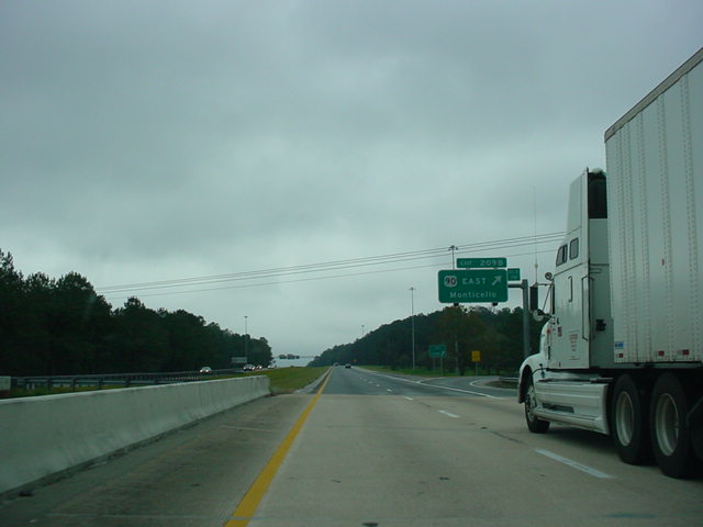 |
Interstate 10 East at
Exit 209B - U.S. 90 East - Monticello. (Photo taken 12/14/03) |
 |
Interstate 10 East at
Exit 217 - FL 59. (Photo taken 12/14/03) |
 |
Interstate 10 East at
Exit 225 - U.S. 19 - FL-GA Parkway/Monticello/Perry. (Photo taken 12/14/03) |
 |
Interstate 10 East at
Exit 233 - CR 257. (Photo taken 12/14/03) |
 |
Interstate 10 East at
Exit 241 - U.S. 221 - Greenville/Perry. (Photo taken 12/14/03) |
 |
Interstate 10 East at
Exit 251 - FL 14 - Madison/Perry. (Photo taken 12/14/03) |
 |
Interstate 10 East at
Exit 258 - FL 53 - Madison. (Photo taken 12/14/03) |
 |
Interstate 10 East at
Exit 262 - CR 255 - Lee. (Photo taken 12/14/03) |
 |
Interstate 10 East at
Exit 275 - U.S. 90 - Live Oak/Lee. (Photo taken 12/14/03) |
 |
Interstate 10 East at
Exit 283 - U.S. 129 - Live Oak/Jasper. (Photo taken 12/14/03) |
 |
Interstate 10 East at
Exit 292 - CR 137 - Wellborn. (Photo taken 12/14/03) |
 |
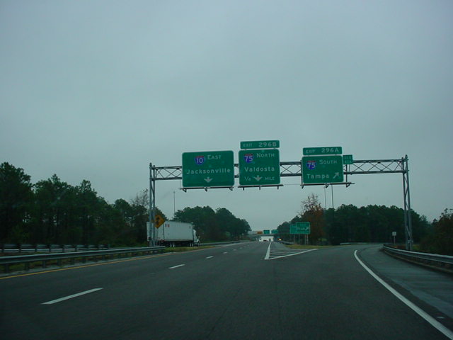
Interstate 10 East
approaching Exits 296A-B - Interstate 75 - 1 1/2 miles. (Photo taken 12/14/03) |
 |
Interstate 10 East
approaching Exits 296A-B - 1 mile. (Photo taken 12/14/03) |
 |
Interstate 10 East at
Exit 296A - Interstate 75 South - Tampa. (Photo taken 12/14/03) |
Highway Links
Florida:
SouthEastRoads.com (Andy Field/Alex Nitzman)
Page created: February 12, 2005
Last updated:
February 12, 2005