 |
Home Search OKRoads: |
|
|
Home Search OKRoads: |
Interstate 126 South Carolina
Interstate 126 is a 3.68-mile spur from Interstate 26 just southeast of Interstate 20 to U.S. 21/U.S. 176/U.S. 321 near downtown Columbia. The interstate does not have exit numbers, and is entirely duplexed with U.S. 76. The only full interchange between the endpoints of the interstate is at Greystone Boulevard.
|
Highway Information |
|
| Miles | 3.68 |
| Counties Traveled Through |
Richland |
| Cities | Columbia |
| Major Junctions | Interstate 26 |
| OKRoads Coverage | |
| Miles Driven by OKRoads (Percentage) |
4 (100%) |
| Western End of Interstate Driven |
Interstate 26 |
| Eastern End of Interstate Driven |
U.S. 21/U.S. 176/ U.S. 321 |
Pictures
| Interstate 126 and U.S. 76 East | |
 |
Interstate 126 and U.S. 76 East as the ramp from Interstate 26 West merges onto the spur. The Lester Bates Freeway heads underneath the ramp from Interstate 126 and U.S. 76 West to Interstate 26 East in this view. (Photo taken 7/7/05) |
 |
Interstate 126 and U.S. 76 East assurance shields as we make our way toward downtown Columbia. Just to the left is the departure of the ramp connecting Interstate 126 westbound to Interstate 26 eastbound. (Photo taken 7/7/05) |
 |
Interstate 126 and U.S. 76 East approaching Greystone Boulevard - 1 1/4 miles. Just south of the interstate is the Riverbanks Zoo, located along the banks of the Saluda River. (Photo taken 7/7/05) |
 |
This mileage sign sums up Interstate 126, one-half mile west of Greystone Boulevard. Huger Street (U.S. 21/U.S. 176/U.S. 321) marks the eastern terminus of the interstate in two miles. Downtown Columbia is 3 1/2 miles ahead. (Photo taken 7/7/05) |
 |
Interstate 126 and U.S. 76 East at Greystone Boulevard/Riverbanks Zoo. The connection is made via a tight loop ramp signed with an advisory speed of 20 mph. (Photo taken 7/7/05) |
 |
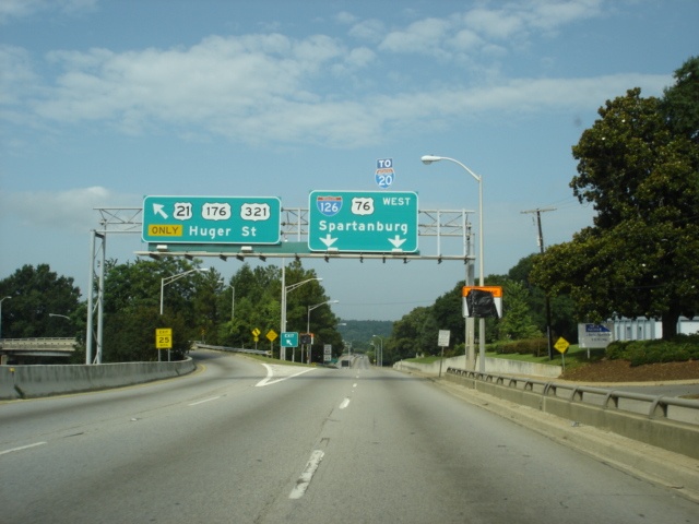
Interstate 126 and U.S. 76 East approaching Huger Street - 1 mile. Huger Street carries U.S. 21, U.S. 176, and U.S. 321 out of the downtown Columbia area. None of the federal highways are mentioned from Interstate 126 eastbound. (Photo taken 7/7/05) |
 |
Use Huger Street southbound to the state museum and Amtrak station. A visitor information center is also located nearby. (Photo taken 7/7/05) |
 |
The two right lanes prepare to exit onto Huger Street as Interstate 126 and U.S. 76 East prepare to cross the Broad River. The Broad River merges with the Saluda River just behind the trees on the right, and together they form the Congaree River. A freeway ends advisory is also posted here, one-half mile west of the interstate's terminus. (Photo taken 7/7/05) |
 |
Pull-through panels indicate that Interstate 126 does continue past Huger Street, but just for a short time. An unsigned business spur carries the 126 number further eastward to downtown Columbia. (Photo taken 7/7/05) |
 |
Interstate 126 and U.S. 76 East at Huger Street (U.S. 21/U.S. 176/U.S. 321 South). The speed limit falls to 35 as Interstate 126 transitions to Elmwood Avenue. (Photo taken 7/7/05) |
 |
U.S. 21/U.S. 176/U.S. 321 North/U.S. 76 East assurance shields as Elmwood Avenue has now begun. The arterial ends one mile ahead at Pickens Street. (Photo taken 7/7/05) |
| Interstate 126 and U.S. 76 West | |
 |
View of the transition from Elmwood Avenue to Interstate 126. Motorists desiring to continue on U.S. 21/U.S. 176/U.S. 321 will use the left lane to exit Interstate 126 onto Huger Street. A "TO Interstate 20" assembly is affixed to the pull-through panel, but is missing its Interstate 20 shield. (Photo taken 7/7/05) |
 |
Interstate 126 and U.S. 76 West and U.S. 21/U.S. 176/U.S. 321 South at U.S. 21/U.S. 176/U.S. 321 South/Huger Street. (Photo taken 7/7/05) |
 |
Interstate 126 and U.S. 76 West approaching Greystone Boulevard - 1 mile, as the interstate prepares to cross the Broad River. Motorists coming from Huger Street northbound merge onto the interstate from the left. (Photo taken 7/7/05) |
 |
Mileage sign on Interstate 126 and U.S. 76 West immediately after crossing the Broad River. Interstate 26 is 2 1/4 miles ahead. (Photo taken 7/7/05) |
 |
Interstate 126 and U.S. 76 West approaching Greystone Boulevard - 1/2 mile. (Photo taken 7/7/05) |
 |
Interstate 126 and U.S. 76 West at Greystone Boulevard/Riverbanks Zoo. Take a left turn at the end of this off-ramp to the zoo and botantical gardens. The pull-through panel jumps ahead about two miles to Interstate 126's merge onto its parent route. (Photo taken 7/7/05) |
 |
Interstate 126 and U.S. 76 West approaching Colonial Life Boulevard - 1 mile. The north-south street is merely a connector between Interstate 126 and U.S. 76 west and the nearby Bush River Road. The first notice of the Interstate 26 East ramp is also posted on the Greystone Boulevard overpass. (Photo taken 7/7/05) |
 |
Interstate 126 and U.S. 76 West approaching Colonial Life Boulevard - 1/2 mile, and Interstate 26 East - 1 mile. A separate ramp allows motorists to get from Interstate 126 to Interstate 20 without crossing over several lanes of Interstate 26 within a short time. (Photo taken 7/7/05) |
 |
Interstate 126 and U.S. 76 West at Colonial Life Boulevard/TO Bush River Road. An exit number appears for the first time on Interstate 126 for the ramp to Interstate 20, but it uses Interstate 26's mileage. (Photo taken 7/7/05) |
 |
Interstate 126 and U.S. 76 West at Interstate 26 East - Charleston. South Carolina's 2nd largest city is a 114 mile drive from the western terminus of Interstate 126. (Photo taken 7/7/05) |
 |
Interstate 126 and U.S. 76 West approaching Exit 107 - Interstate 20 - 1/4 mile. The ramp merges onto Interstate 26 West's rightmost lanes prior to the Interstate 20 interchange. (Photo taken 7/7/05) |
 |
Interstate 126 and U.S. 76 West at Exit 107 - Interstate 20 - Florence/Augusta. Florence is 85 miles east of Interstate 26 and marks Interstate 20's eastern terminus at Interstate 95. Augusta is 68 miles to the southwest and is on the South Carolina-Georgia state line. (Photo taken 7/7/05) |
 |
Although traffic bound for Interstate 20 should have already departed by this time, this mileage sign indicates the distance to Interstate 20 (1/2 mile) and the two subsequent exits off of Interstate 26 and U.S. 76 (St. Andrews Road, 1 1/4 mile, and Piney Grove Road, 3 miles). There is no end sign as Interstate 126 transitions into Interstate 26 ahead. Bush River Road crosses over the interstate during the transition. (Photo taken 7/7/05) |
Page created: December 11, 2005
Last updated:
December 11, 2005