 |
Home Search OKRoads: |
|
|
Home Search OKRoads: |
Interstate 74 Ohio
|
Highway Information |
|
| Miles | 19.47 |
| Counties Traveled Through |
Hamilton |
| Cities | Cincinnati |
| Major Junctions |
Interstate 275 (Exit 5 & Exit 9)
Interstate 75 |
| OKRoads Coverage | |
| Miles Driven by OKRoads (Percentage) |
19 (100%) |
| Western End of Interstate Driven |
Indiana State Line |
| Eastern End of Interstate Driven |
Interstate 75 |
Pictures
| Interstate 74 and U.S. 52 West and U.S. 27 North | |
 |
Interstate 74 and U.S. 52 West and U.S. 27 North approaching Exit 19 - Elmore Street/Spring Grove Avenue - 1/2 mile. This sign is located before Interstate 74 travels underneath Interstate 75. (Photo taken 7/11/05) |
 |
Interstate 74 and U.S. 52 West and U.S. 27 North approaching Exit 19 - Elmore Street/Spring Grove Avenue - 1/4 mile, and Exit 18 - U.S. 27 North - 1/2 mile. (Photo taken 7/11/05) |
 |
Interstate 74 and U.S. 52 West and U.S. 27 North at Exit 19 - Elmore Street/Spring Grove Avenue. (Photo taken 7/11/05) |
 |
Use Exit 18 to the Mount Airy Forest. The forest covers nearly 1,500 acres in the west part of Cincinnati. (Photo taken 7/11/05) |
 |
Interstate 74 and U.S. 52 West approaching Exit 18 - U.S. 27 North - 1/4 mile. U.S. 27 leaves the interstate and travels northward on Colerain Avenue. (Photo taken 7/11/05) |
 |
Interstate 74 and U.S. 52 west at Exit 18 - U.S. 27 North/Colerain Avenue. (Photo taken 7/11/05) |
| Interstate 74 and U.S. 52 West | |
 |
Interstate 74 and U.S. 52 West approaching Exit 17 - Montana Avenue - 3/4 mile. Montana Avenue connects Interstate 74 to the Cincinnati suburb of Cheviot. (Photo taken 7/11/05) |
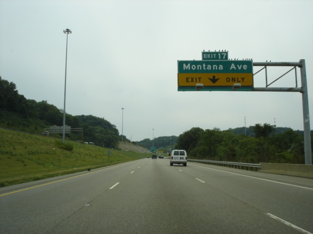 |
Interstate 74 and U.S. 52 West approaching Exit 17 - Montana Avenue - 1/4 mile. Exit 17 is a partial interchange, with only a westbound off-ramp and eastbound on-ramp available. (Photo taken 7/11/05) |
 |
Interstate 74 and U.S. 52 West at Exit 17 - Montana Avenue. (Photo taken 7/11/05) |
 |
Interstate 74 and U.S. 52 West approaching Exit 14 - North Bend Road/Cheviot - 1 1/2 miles. This also marks the point where Interstate 74 and U.S. 52 leave the corporate limits of Cincinnati. (Photo taken 7/11/05) |
 |
Interstate 74 and U.S. 52 West approaching Exit 14 - North Bend Road/Cheviot - 3/4 mile. The city of Cheviot has a population of 9,015. (Photo taken 7/11/05) |
 |
Interstate 74 and U.S. 52 West approaching Exit 14 - North Bend Road/Cheviot - 1/4 mile. (Photo taken 7/11/05) |
 |
Interstate 74 and U.S. 52 West at Exit 14 - North Bend Road/Cheviot. The middle sign should say "Right Lane Ends Merge Left," but is missing the top part of the sign. (Photo taken 7/11/05) |
 |
Mileage sign on Interstate 74 and U.S. 52 West just past Exit 14. Indianapolis is 94 miles ahead. (Photo taken 7/11/05) |
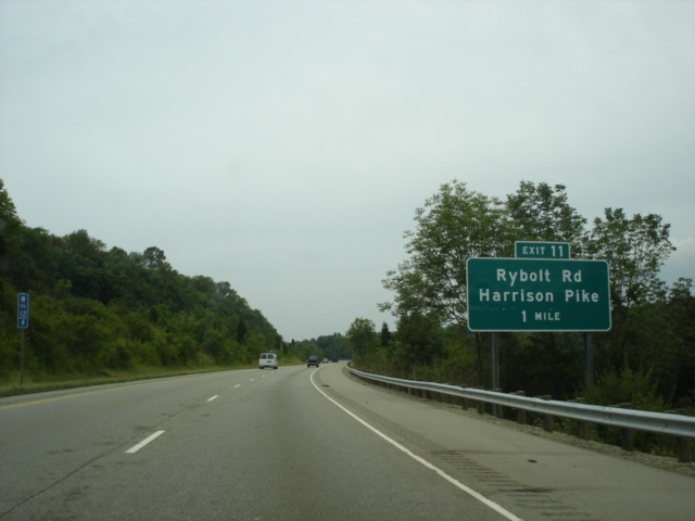 |
Interstate 74 and U.S. 52 West approaching Exit 11 - Rybolt Road/Harrison Pike - 1 mile. Rybolt Road begins at this interchange and travels south to Taylor Road. Harrison Pike is a former routing of U.S. 52 between Harrison and Cincinnati. (Photo taken 7/11/05) |
 |
Interstate 74 and U.S. 52 West approaching Exit 11 - Rybolt Road/Harrison Pike - 1/4 mile. (Photo taken 7/11/05) |
 |
Interstate 74 and U.S. 52 West at Exit 11 - Rybolt Road/Harrison Pike. (Photo taken 7/11/05) |
 |
Interstate 74 and U.S. 52 West approaching Exit 9 - Interstate 275 North - 1 1/4 mile. Interstate 74 and U.S. 52 narrow to one lane through the upcoming interchange with the Cincinnati beltway. (Photo taken 7/11/05) |
 |
Interstate 74 and U.S. 52 West approaching Exit 9 - Interstate 275 North - 3/4 mile. Interstate 275 meets its parent route 15 miles to the northeast. (Photo taken 7/11/05) |
 |
Interstate 74 and U.S. 52 West approaching Exit 9 - Interstate 275 North - 1/2 mile. Dayton is 52 miles to the north. (Photo taken 7/11/05) |
 |
Interstate 74 and U.S. 52 West at Exit 9 - Interstate 275 North to Interstate 75 - Dayton. (Photo taken 7/11/05) |
| Interstate 74 and U.S. 52 West and Interstate 275 South | |
 |
Interstate 74 and U.S. 52 West and Interstate 275 South assurance shields just past Exit 9. Interstate 275 shares four miles of freeway with Interstate 74 and U.S. 52. (Photo taken 7/11/05) |
 |
Interstate 74 and U.S. 52 West and Interstate 275 South approaching Exit 7 - Ohio 128 - 3/4 mile. Ohio 128 spans 22.3 miles from U.S. 50 in Cleves to U.S. 127 in Hamilton. (Photo taken 7/11/05) |
 |
Use Exit 7 to the Miamitown Park & Ride lot. (Photo taken 7/11/05) |
 |
Interstate 74 and U.S. 52 West and Interstate 275 South approaching Exit 7 - Ohio 128 - 1/4 mile. Cleves is five miles to the south, and Hamilton is 17 miles to the northeast. (Photo taken 7/11/05) |
 |
Interstate 74 and U.S. 52 West and Interstate 275 South at Exit 7 - Ohio 128 - Cleves/Hamilton. (Photo taken 7/11/05) |
 |
Interstate 74 and U.S. 52 West and Interstate 275 South approaching Exit 5 - Interstate 275 South - 1 mile. Interstate 275 has one more interchange (Exit 21 at Kilby Road) before leaving Ohio for Kentucky. (Photo taken 7/11/05) |
 |
Use Interstate 275 South to Exit 16 to Lawrenceburg, Indiana. Continue on Interstate 275 to Exit 4 to the Cincinnati/Northern Kentucky International Airport. (Photo taken 7/11/05) |
 |
Interstate 74 and U.S. 52 West and Interstate 275 South approaching Exit 5 - Interstate 275 South - 1/2 mile. Two lanes are provided for the continuation of both interstates. (Photo taken 7/11/05) |
 |
Interstate 74 and U.S. 52 West and Interstate 275 South at Exit 5 - Interstate 275 South - Kentucky. Interstate 275 enters Indiana in seven miles and Kentucky in ten miles. (Photo taken 7/11/05) |
| Interstate 74 and U.S. 52 West | |
 |
Interstate 74 and U.S. 52 West approaching Exit 3 - Dry Fork Road - 1 mile. Dry Fork Road is 2.4 miles and connects Harrison Road to New Haven Road. (Photo taken 7/11/05) |
 |
Use northbound Dry Fork Road to the Miami Whitewater Forest. (Photo taken 7/11/05) |
 |
Interstate 74 and U.S. 52 West approaching Exit 3 - Dry Fork Road - 1/2 mile. (Photo taken 7/11/05) |
 |
Interstate 74 and U.S. 52 West approaching Exit 3 - Dry Fork Road - 1/4 mile. (Photo taken 7/11/05) |
 |
Interstate 74 and U.S. 52 West at Exit 3 - Dry Fork Road. (Photo taken 7/11/05) |
 |
Interstate 74 and U.S. 52 West approaching Exit 1 - New Haven Road - 1 mile. New Haven Road provides the main access to the city of Harrison (pop. 7,487) from Interstate 74. (Photo taken 7/11/05) |
 |
Interstate 74 and U.S. 52 West approaching Exit 1 - New Haven Road - 1/2 mile. (Photo taken 7/11/05) |
 |
Interstate 74 and U.S. 52 West at Exit 1 - New Haven Road - Harrison. The interstate will enter the state of Indiana in about 1.5 miles. (Photo taken 7/11/05) |
Page created: February 16, 2006
Last updated:
February 16, 2006