 |
Home Search OKRoads: |
|
|
Home Search OKRoads: |
Interstate 90 South Dakota
|
Highway Information |
|
| Miles | 412.76 |
| Counties Traveled Through |
Lawrence, Meade, Pennington, Jackson, Jones, Lyman, Brule, Aurora, Davison, Hanson, McCook, Minnehaha |
| Cities |
Spearfish, Sturgis, Rapid City, Chamberlain, Mitchell, Sioux Falls |
| Major Junctions | Interstate 190 (Exit 57)
Interstate 29 Interstate 229 |
| OKRoads Coverage | |
| Miles Driven by OKRoads (Percentage) |
17 (4%) |
| Western End of Interstate Driven |
Interstate 29 |
| Eastern End of Interstate Driven |
Minnesota State Line |
Pictures
| Interstate 90 West | |
 |
Welcome to South Dakota sign as Interstate 90 enters the state that is home to the Black Hills, Sturgis, and Mount Rushmore. Interstate 90 spends 412.76 miles in South Dakota, the 2nd most miles of any state that the transcontinental interstate travels through. (Photo taken 7/13/05) |
 |
Interstate 90 West at the Minnehaha County rest area and South Dakota welcome center. The next rest area is 50 miles ahead in McCook County. (Photo taken 7/13/05) |
 |
South Dakota 11 was closed between Interstate 90 and Garretson due to construction. Traffic was to use Exit 410 and head north to the state highway. (Photo taken 7/13/05) |
 |
Interstate 90 West approaching Exit 410 - Valley Springs/Garretson - 1/2 mile. The exit serves 468th Avenue. (Photo taken 7/13/05) |
 |
Head north on 468th Avenue to the Palisades State Park. Use 468th Avenue southbound to the Beaver Creek Nature Area. (Photo taken 7/13/05) |
 |
Interstate 90 West at Exit 410 - 468th Avenue - Valley Springs/Garretson. (Photo taken 7/13/05) |
 |
Interstate 90 West approaching Exit 406 - South Dakota 11 - 1 mile. The state highway travels 80.4 miles from South Dakota 48 east of Spink to the Minnesota state line, where it becomes Minnesota 269. (Photo taken 7/13/05) |
 |
Use South Dakota 11 South to the Big Sioux Recreation Area. (Photo taken 7/13/05) |
 |
Interstate 90 West at Exit 406 - South Dakota 11 - Corson/Brandon. The city of Brandon (pop. 5,693) is just to the south. (Photo taken 7/13/05) |
 |
Mileage sign on Interstate 90 West just past South Dakota 11. Interstate 229 begins five miles ahead. Sioux Falls is eight miles away. (Photo taken 7/13/05) |
 |
Interstate 90 West approaching Exit 402 - 478th Avenue - 1 mile. Ten miles to the north is the EROS Data Center at the U.S. Geological Survey. (Photo taken 7/13/05) |
 |
Interstate 90 West at Exit 402 - 478th Avenue. (Photo taken 7/13/05) |
 |
Interstate 90 West approaching Exit 400 - Interstate 229 - 2 miles. Interstate 229 connects Interstate 29 to Interstate 90 and travels through east Sioux Falls. (Photo taken 7/13/05) |
 |
The next three exits serve the city of Sioux Falls. It is South Dakota's largest city with a population of 123,975, and growing. (Photo taken 7/13/05) |
 |
Sioux Falls is the hometown of freshman U.S. Senator John Thune. (Photo taken 7/13/05) |
 |
Interstate 90 West approaching Exit 400 - Interstate 229 - 1/2 mile. (Photo taken 7/13/05) |
 |
Interstate 90 West at Exit 400 - Interstate 229. (Photo taken 7/13/05) |
 |
Interstate 90 West approaching Exit 399 - Downtown Spur Interstate 90/South Dakota 115 - 1/2 mile. Sioux Falls has three downtown spurs/loops, one from each interstate that passes through the city. (Photo taken 7/13/05) |
 |
Use Exit 399 to the Sioux Falls Stockyards and Falls Park. (Photo taken 7/13/05) |
 |
Interstate 90 West at Exit 399 - Downtown Spur Interstate 90/South Dakota 115 - Airport/Cliff Avenue. The Sioux Falls Regional Airport is three miles to the south. (Photo taken 7/13/05) |
 |
The next interchange is the only interstate-to-interstate interchange in South Dakota where one of the interstates does not terminate. Use Interstate 29 North to the Terry Redlin Art Center, located in Watertown at Exit 177. (Photo taken 7/13/05) |
 |
Interstate 90 West approaching Exits 396B-A - Interstate 29 - 2 miles. Interstate 29 is the main north-south interstate through eastern South Dakota. (Photo taken 7/13/05) |
 |
Interstate 90 West approaching Exits 396B-A - Interstate 29 - 1 mile. The control cities of Fargo and Sioux City do not appear on any signage at the interchange itself. (Photo taken 7/13/05) |
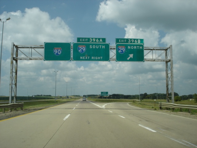 |
Interstate 90 West at Exit 396B - Interstate 29 North - Fargo. North Dakota's largest city is 237 miles to the north. (Photo taken 7/13/05) |
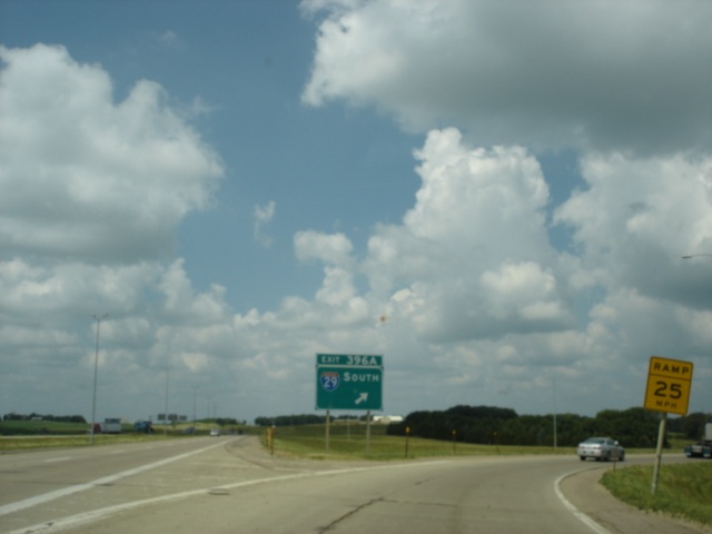 |
Interstate 90 West at Exit 396A - Interstate 29 South - Sioux City. The Iowa city is 90 miles to the south. (Photo taken 7/13/05) |
Page created: March 12, 2006
Last updated:
March 12, 2006