 |
Home Search OKRoads: |
|
|
Home Search OKRoads: |
New York 17
New York 17 is currently the longest state highway in New York. Much of it is four-lane divided along the Pennsylvania border. The Southern Tier Expressway carries New York 17 (and Interstate 86) between the Pennsylvania state line and Interstate 81 in Binghamton. From Interstate 81 southeast to Interstate 87 in Harriman, New York 17 is known as the Quickway as it goes through the Catskill Mountains. Just before it reaches Interstate 87 (also the New York State Thruway), New York 17 heads south to the New Jersey state line.
New York 17's mileage will be cut drastically upon full completion of upgrading the state highway to interstate standards from Pennsylvania to Harriman. Interstate 86 has already been commissioned between Interstate 90 near Erie, Pennsylvania, and New York 14 in Horseheads, and will be extended eastward as upgrades are completed.
Pictures
| New York 17 East | |
 |
New York 17 East approaching Center Street in the village of Horseheads. Construction is in progress to make this at-grade section a freeway. When completed, Interstate 86 will be signed further eastward from its current eastern terminus at New York 14. (Photo taken 7/9/05) |
 |
New York 17 East approaching Main Street. This is the final stoplight seen on New York 17 eastbound. (Photo taken 7/9/05) |
 |
New York 17 East at Exit 54 - New York 13 - Ithaca. The state highway enters the city of 29,287 in 29 miles. The trumpet interchange marks the southern terminus of New York 13. (Photo taken 7/9/05) |
 |
New York 17 East and Southern Tier Expressway assurance shields just past Exit 54. The expressway heads almost due south between Horseheads and Elmira. (Photo taken 7/9/05) |
 |
New York 17 East approaching Exit 56 - New York 352 - 1 mile. This interchange was recently reconstructed in conjunction with the future status of the state highway as Interstate 86. (Photo taken 7/9/05) |
 |
New York 352 uses both Church Street and Water Street through the city of Elmira, population 30,940. This is the only exit to directly serve the Chemung County seat. (Photo taken 7/9/05) |
 |
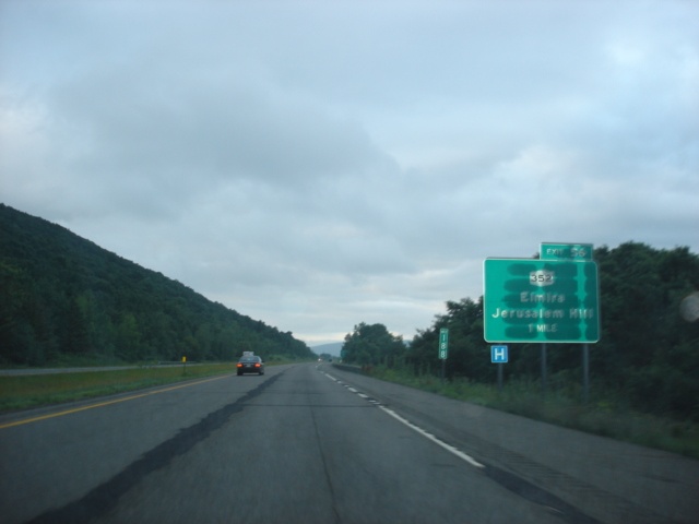
New York 17 East at Exit 56 - New York 352 - Elmira/Jerusalem Hill. (Photo taken 7/9/05) |
 |
South of Elmira, New York 17 goes through a short at-grade stretch. It is the final one on New York 17 until Deposit. (Photo taken 7/9/05) |
 |
New York 17 East approaching Exit 58 - Chemung County 2, Chemung County 8, and Chemung County 60 - 1 mile. It is rare to see three county route pentagons signed on an exit BGS on a major freeway, but here it is. (Photo taken 7/9/05) |
 |
New York 17 East at Exit 58 - Chemung County 2/Chemung County 8/Chemung County 60 - Lowman/Wellsburg. (Photo taken 7/9/05) |
 |
New York 17 East approaching Exit 59 - New York 427 - 1 mile. The state highway meets its eastern terminus at Exit 59 and goes west to New York 14 in Southport. (Photo taken 7/9/05) |
 |
New York 17 East at Exit 59 - New York 427 - Chemung. For the next several miles, New York 17 follows the Pennsylvania state line very closely. As we will see later, it even enters the Keystone State for a bit. (Photo taken 7/9/05) |
 |
New York 17 East approaching Exit 59A - Wilawana - 1 mile. (Photo taken 7/9/05) |
 |
New York 17 East at Exit 59A - Wilawana. New York 17 passes by mile marker 202 here. (Photo taken 7/9/05) |
 |
New York 17 East approaching Exit 60 - U.S. 220 - 1 mile. This exit is located entirely within Pennsylvania. New York 17 is signed within Pennsylvania as such. (Photo taken 7/9/05) |
 |
Continue to Exit 61 to the Guthrie Clinic, located in Sayre, Pennsylvania. (Photo taken 7/9/05) |
 |
New York 17 East at Exit 60 - U.S. 220 - Waverly/Sayre. U.S. 220, which begins its northbound journey in Rockingham, North Carolina, ends at this interchange. (Photo taken 7/9/05) |
 |
New York 17 enters Pennsylvania at this point at the Exit 60 ramp departs. The points where New York 17 enters Pennsylvania are marked with "State Border" signs, like the one seen here, instead of a full Welcome to Pennsylvania sign. (Photo taken 7/9/05) |
 |
View of the off-ramp from New York 17 East to U.S. 220 South. Remember, this is all in Pennsylvania. U.S. 220 begins its southerly journey as an expressway that begins immediately after turning right ahead. (Photo taken 7/9/05) |
 |
New York 17 East approaching Exit 61 - New York 34/Pennsylvania 199 - 1/2 mile. The state highways serve the cities of Sayre, Pennsylvania, and Waverly, New York. (Photo taken 7/9/05) |
 |
New York 17 East at Exit 61 - New York 34/Pennsylvania 199 - Waverly/Sayre. At this point, the state line is in the median. So, technically, New York 17 eastbound is in Pennsylvania, while New York 17 westbound is in New York. New York 17 eastbound re-enters New York for good just past this folded diamond interchange. (Photo taken 7/9/05) |
 |
New York 17 East approaching the Tioga County rest area - 3/4 mile. (Photo taken 7/9/05) |
 |
New York 17 East at the Tioga County rest area. (Photo taken 7/9/05) |
 |
New York 17 East approaching Exit 62 - New York 282 - 1 mile. New York 282 spans 3.5 miles from the Pennsylvania state line to New York 17C. New York 17C is the original route of New York 17 between Waverly and Binghamton. (Photo taken 7/9/05) |
 |
Use New York 282 north to Smithboro and Tioga Center. Both are located along New York 17C. (Photo taken 7/9/05) |
 |
New York 17 East at Exit 62 - New York 282 - Nichols. The town is home to 2,584 people. (Photo taken 7/9/05) |
 |
New York 17 East approaching Exit 63 - Lounsberry - 1 mile. (Photo taken 7/9/05) |
 |
New York 17 East at Exit 63 - Lounsberry. (Photo taken 7/9/05) |
 |
New York 17 East approaching Exit 64 - New York 96 - 1 mile. The state highway begins at Exit 64 and goes north to Waterloo. From there, the highway heads west near the New York State Thruway to Rochester. (Photo taken 7/9/05) |
 |
New York 17 East at Exit 64 - New York 96 - Owego/Ithaca. Owego, the seat of Tioga County, is home to 20,365 residents. (Photo taken 7/9/05) |
 |
New York 17 East approaching Exit 65 - New York 17C and New York 434 - 1 mile. This would be Exit 225 if mileage-based exits were used. (Photo taken 7/9/05) |
 |
New York 17 East at Exit 65 - New York 17C and New York 434 - Owego. New York 17 closely follows the Susquehanna River through Owego, Endicott, and Binghamton. The river is just to the north. (Photo taken 7/9/05) |
 |
New York 17 East approaching Exit 66 - New York 17C and New York 434 - 1 mile. New York 434 runs just south of New York 17 while New York 17C is just north of the Susquehanna River. (Photo taken 7/9/05) |
 |
New York 17 East at Exit 66 - New York 17C and New York 434 - Apalachin. The BC Open professional golf tournament took place one week after we were in the area at the En-Joie Golf Course. (Photo taken 7/9/05) |
 |
New York 17 East approaching Exits 67S-N - New York 26 and New York 434 - 1 mile. New York 26 is a lengthy north-south highway that goes north until reaching New York 12 in Alexandria Bay, just south of the Canadian border. (Photo taken 7/9/05) |
 |
New York 17 East approaching Exit 67S - New York 26 South/To New York 434 - 1/4 mile. New York commonly posts signs like these prior to the actual departure of the exit ramp. At the exit ramp departure, a sign bridge is typically used. (Photo taken 7/9/05) |
 |
New York 17 East at Exit 67S - New York 26 South to New York 434 - Vestal. A folded diamond interchange with New York 434 is located just south of New York 17. (Photo taken 7/9/05) |
 |
New York 17 East at Exit 67N - New York 26 North - Endicott. Endicott village (pop. 13,038) is on the north side of the Susquehanna River. (Photo taken 7/9/05) |
 |
New York 17 East approaching Exit 68 - Old Vestal Road - 1/2 mile. Truck weight is limited to 5 tons on the road. (Photo taken 7/9/05) |
 |
New York 17 East at Exit 68 - Old Vestal Road. (Photo taken 7/9/05) |
 |
New York 17 East approaching Exit 69 - New York 17C East - 1 mile. This is the final time the two well-acquainted highways meet. (Photo taken 7/9/05) |
 |
A light rain began to fall as we entered the village of Johnson City. Use exits 69, 70, and 71 to the village. (Photo taken 7/9/05) |
 |
New York 17 East at Exit 69 - New York 17C East - Westover. The sign is blocked by a light pole and a state speed limit sign. (Photo taken 7/9/05) |
 |
New York 17 eastbound widens to three lanes as it enters Johnson City. Use Exit 70S (New York 201 South) to Binghamton University. Use Exit 70N (Reynolds Road) to Harry L Drive. (Photo taken 7/9/05) |
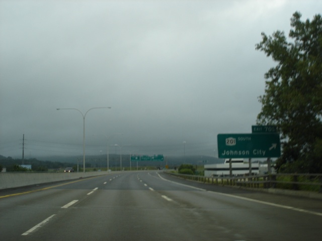 |
New York 17 East at Exit 70S - New York 201 South - Johnson City. New York 201 is a two-mile freeway between New York 434 near Binghamton University and New York 17. (Photos taken 7/9/05) |
 |
|
 |
New York 17 East at Exit 70N - Shopping Mall. The Oakdale Mall is located just north of Harry L Drive. (Photo taken 7/9/05) |
 |
New York 17 East approaching Exit 71 - Airport Road - 1/2 mile. The Greater Binghamton Airport is eight miles to the north of the upcoming exit. (Photo taken 7/9/05) |
 |
Use Exit 71 to the area's Board of Cooperative Educational Services (BOCES) and the Broome Developmental Center. (Photo taken 7/9/05) |
 |
New York 17 East at Exit 71 - Airport Road/Greater Binghamton Airport. (Photo taken 7/9/05) |
 |
New York 17 East approaching Interstate 81 - 2 miles. The infamous "Kamikaze Curve" is located just before the interchange. Also coming into play at the interchange is U.S. 11, which is served by a slip ramp, signed as Exit 72. (Photo taken 7/9/05) |
 |
This old diagram sign shows a bit what lies ahead. Exit 72 (U.S. 11) is one mile ahead, and Interstate 81 is just past the exit. The two right lanes go to Interstate 81 South and New York 17 East, while the left lane goes to Interstate 81 North. The western terminus of Interstate 88 is two miles north of New York 17. (Photo taken 7/9/05) |
 |
View from New York 17 East about 3/4 mile west of Interstate 81. (Photo taken 7/9/05) |
 |
New York 17 East approaching Exit 72 - U.S. 11 - 1/2 mile. U.S. 11 skirts the western shore of the Chenango River in the Binghamton area. U.S. 11 closely follows Interstate 81 for most of the interstate's route through Tennessee, Virginia, West Virginia, Maryland, Pennsylvania, and New York. (Photo taken 7/9/05) |
 |
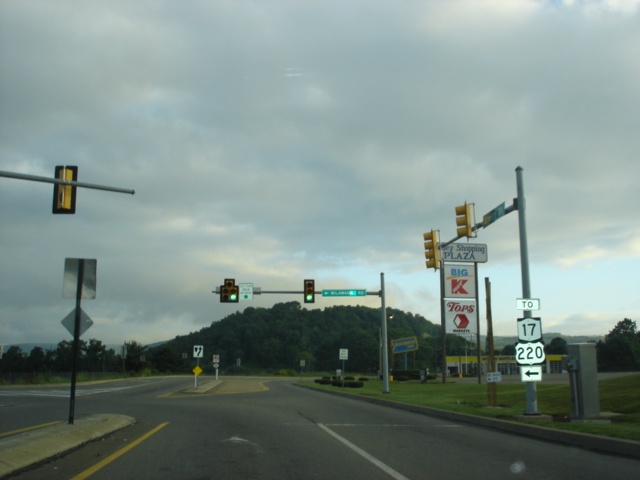
Use U.S. 11 (Front Street) southbound to Clinton Street, which provides one of three crossings into downtown Binghamton. The other two are provided by U.S. 11, which turns to the east to cross the Chenango River along Court Street, and Riverside Drive to the south near the point where the Chenango runs into the Susquehanna. (Photo taken 7/9/05) |
 |
New York 17 East at Exit 72 - U.S. 11 - Front Street to Downtown Binghamton. The Kamikaze curve itself is seen in these pictures. Plans call for a straightening of the curve to occur in the near future. (Photos taken 7/9/05) |
 |
|
 |
New York 17 East approaching Interstate 81. The middle lane widens to two lanes, one for each direction of Interstate 81. (Photo taken 7/9/05) |
 |
New York 17 East at Interstate 81 North to Interstate 88 East - Syracuse/Albany. Syracuse is 72 miles to the north, and Albany is 137 miles to the northeast via Interstate 81 North, Interstate 88 East, and Interstate 90 East. (Photo taken 7/9/05) |
| Scenes Related to New York 17 | |
 |
New York 14 South approaching New York 17 East in Horseheads. To the right is the westbound beginning of Interstate 86. (Photo taken 7/8/05) |
 |
Close-up picture of New York 14 South approaching New York 17 East. The signs are on the New York 17 overpass. (Photo taken 7/9/05) |
 |
New York 14 South at New York 17 East in Horseheads. (Photo taken 7/9/05) |
 |
Elmira Street northbound at Wilawana Road in Sayre, Pennsylvania. New York 17 is just to the north. However, the state highway is in Pennsylvania when it meets U.S. 220. (Photo taken 7/9/05) |
 |
Wilawana Road westbound at U.S. 220 North to New York 17. Waverly, New York is one mile to the north. (Photo taken 7/9/05) |
 |
U.S. 220 North approaching New York 17. The trees straight ahead are in New York. The interchange itself, however, is in Pennsylvania. (Photo taken 7/9/05) |
 |
U.S. 220 North approaching New York 17 East. The freeway suddenly comes to an end at the state highway, where the movements are governed by traffic lights. (Photo taken 7/9/05) |
 |
U.S. 220 North at New York 17 East. We are still in Pennsylvania, but are intersecting a New York state highway. U.S. 220 enters New York very briefly as an end sign is posted in the Empire State just before the roadway ends at New York 17C. (Photo taken 7/9/05) |
Page created: January 05, 2006
Last updated:
January 05, 2006