 |
Home Search OKRoads: |
|
|
Home Search OKRoads: |
U.S. 277 Texas
U.S. 277 spends most of its miles in the state of Texas. Beginning at U.S. 83 in Carrizo Springs, U.S. 277 connects Del Rio, Sonora, San Angelo, Abilene, Seymour, and Wichita Falls. For pictures of U.S. 277 in Oklahoma, please visit the U.S. 277 guide at OKHighways.com. (The page will open in a separate window)
Pictures
 |
U.S. 83 and U.S. 277 North at Interstate 20 West. El Paso is only 443 miles to the west. (Photo taken 3/18/05) |
 |
U.S. 83 and U.S. 277 North approaching Farm to Market Road 2404 - 1/2 mile. (Photo taken 3/18/05) |
 |
U.S. 83 and U.S. 277 North at Farm to Market Road 2404 - Old Anson Road/Impact. (Photo taken 3/18/05) |
 |
U.S. 83 and U.S. 277 North at Business U.S. 83 South on the outskirts of Abilene. The freeway becomes a 4-lane divided expressway just past this exit. (Photo taken 3/18/05) |
 |
U.S. 83 and U.S. 277 North at Farm to Market Road 3034 East. The sign bridge in the southbound lanes is for the Business U.S. 83 exit. (Photo taken 3/18/05) |
 |
U.S. 83 and U.S. 277 North at Farm to Market Road 605 West. The FM road connects to FM 707 six miles to the west. (Photo taken 3/18/05) |
 |
U.S. 83 and U.S. 277 North approaching Farm to Market Road 1082 - 1/2 mile. This is the only interchange between the northern end of Abilene's business route and Anson. (Photo taken 3/18/05) |
 |
U.S. 83 and U.S. 277 North at Farm to Market Road 1082 - Hawley. The town has a population of 646 people. (Photo taken 3/18/05) |
 |
U.S. 83 and U.S. 277 North at Farm to Market Road 3326 East. (Photo taken 3/18/05) |
 |
U.S. 83 and U.S. 277 North at Farm to Market Road 2746 West. (Photo taken 3/18/05) |
 |
U.S. 83 and U.S. 277 North at Farm to Market Road 707 South. The city of Anson is just around the curve. (Photo taken 3/18/05) |
 |
U.S. 83 and U.S. 277 North at U.S. 180 in Anson. The Jones County courthouse is ahead. (Photo taken 3/18/05) |
 |
Closer view of the Jones County courthouse. Anson is the county seat and is home to 2,556 residents. (Photo taken 3/18/05) |
 |
U.S. 83 and U.S. 277 North as they prepare to split north of Anson. The signs underneath the U.S. 83 and U.S. 277 shields say "Left Lane" and "Right Lane" respectively. (Photo taken 3/18/05) |
 |
U.S. 83 and U.S. 277 North at U.S. 83 North. Stamford is 13 miles ahead for those continuing on U.S. 277. (Photo taken 3/18/05) |
 |
U.S. 277 North at Farm to Market Road 1636 West. (Photo taken 3/18/05) |
 |
U.S. 277 North at Texas 92 West. The state highway intersects U.S. 83 in Hamlin 21 miles to the west. (Photo taken 3/18/05) |
 |
U.S. 277 North approaching Stamford. Use the Business U.S. 277 exit, not the turnoff before it, to access southbound Texas 6. (Photo taken 3/18/05) |
 |
U.S. 277 North at Business U.S. 277 North. This business route serves Stamford, population 3,636. (Photo taken 3/18/05) |
 |
U.S. 277 North approaching Business U.S. 277 - 1/4 mile. This is the same business route we just saw, except it will now head to the other side of the mainline U.S. 277. (Photo taken 3/18/05) |
 |
U.S. 277 North at Business U.S. 277 - Stamford. Use this exit to Texas 6 South, which eventually leads to Houston. (Photo taken 3/18/05) |
 |
U.S. 277 North approaching Texas 6/Texas 283 - 3/4 mile. (Photo taken 3/18/05) |
 |
The Texas 6/Texas 283 interchange is also the northern terminus of the Stamford business route. (Photo taken 3/18/05) |
 |
U.S. 277 North at Texas 6/Texas 283 - Rule/Aspermont. (Photo taken 3/18/05) |
 |
View at the end of the off-ramp to Texas 6 and Texas 283. Rule is 18 miles to the north via Texas 6, and Aspermont is 30 miles to the northwest via Texas 283 North and U.S. 380 West. This also marks the southern terminus of Texas 283. (Photo taken 3/18/05) |
 |
U.S. 277 North at Farm to Market Road 618 East. The highway leads to Lake Stamford. (Photo taken 3/18/05) |
 |
U.S. 277 North at Farm to Market Road 1225 West. FM 1225 meets its western end at Texas 6 in nine miles. (Photo taken 3/18/05) |
 |
U.S. 277 North approaching U.S. 380 in Haskell. U.S. 380 connects Brownfield, Tahoka, Haskell, Graham, and Denton before ending at Interstate 30 in Greenville. (Photo taken 3/18/05) |
 |
U.S. 277 North at U.S. 380 in Haskell. The seat of Haskell County, the city has a population of 3,106. (Photo taken 3/18/05) |
 |
U.S. 277 North approaching Farm to Market Road 2163 in north Haskell. FM 2163 sees its northern end at FM 2229 near Knox City. (Photo taken 3/18/05) |
 |
U.S. 277 North at FM 2163 North. U.S. 277 prepares to widen out to four lanes once again. As of March 2005, construction was underway on a bypass of Haskell, along with bypasses of a few other small towns along the route. (Photo taken 3/18/05) |
 |
U.S. 277 North approaching Farm to Market Road 2080 East. FM 2080 is a short route connecting U.S. 277 to FM 266 near Mattson. U.S. 277 was in the midst of a resurfacing project when we were here. (Photo taken 3/18/05) |
 |
U.S. 277 North at Farm to Market Road 2080 East. (Photo taken 3/18/05) |
 |
U.S. 277 North approaching Business U.S. 277. This business route serves Weinert. (Photo taken 3/18/05) |
 |
U.S. 277 North at the Weinert business route. (Photo taken 3/18/05) |
 |
U.S. 277 North at Farm to Market Road 617. FM 617 begins just east of here at Business U.S. 277 in Weinert and travels through Rochester (where it meets Texas 6) before curving southward to end at U.S. 380 in Rule. (Photo taken 3/18/05) |
 |
U.S. 277 North approaching Business U.S. 277 South. This is the northern end of the Weinert business route, and also the northern end of the resurfacing at the time of this photograph. (Photo taken 3/18/05) |
 |
U.S. 277 North at Business U.S. 277 South. (Photo taken 3/18/05) |
 |
U.S. 277 North at Farm to Market Road 1720 East. Use FM 1720 East to Texas 222 East. (Photo taken 3/18/05) |
 |
U.S. 277 North approaching Farm to Market Road 2365. Use FM 2365 West as a shortcut to Texas 222. (Photo taken 3/18/05) |
 |
U.S. 277 North at Farm to Market Road 2365 West. (Photo taken 3/18/05) |
 |
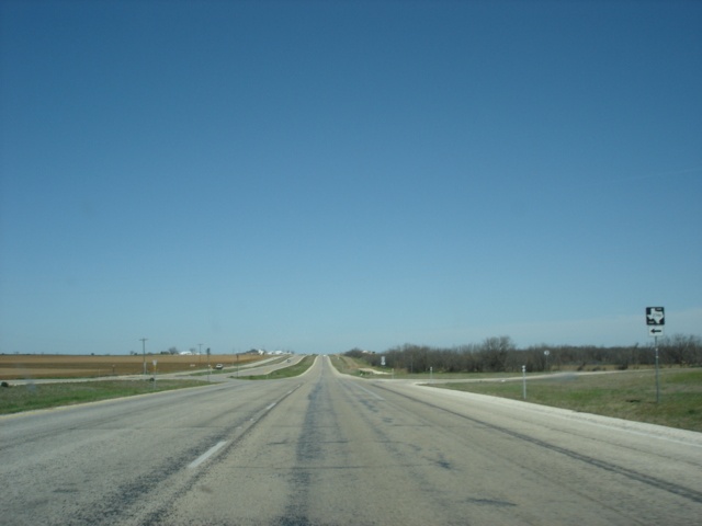
U.S. 277 North approaching Farm to Market Road 267. This is the current northern end of the four-lane divided highway we have seen since Abilene. The federal highway will enter Munday ahead. (Photo taken 3/18/05) |
 |
U.S. 277 North at Farm to Market Road 267 West. FM 267 continues the northerly trek that U.S. 277 will leave behind in Munday. U.S. 277 takes a turn to the east in the city. (Photo taken 3/18/05) |
 |
U.S. 277 North approaching Texas 222 in Munday. Texas 222 begins at U.S. 82 and Texas 114 near Guthrie and heads south and east through Knox City and Munday before ending at U.S. 380 west of Throckmorton. (Photo taken 3/18/05) |
 |
U.S. 277 North at Texas 222. Another sign pointing towards Farm to Market Road 267 is also seen here. (Photo taken 3/18/05) |
 |
U.S. 277 North approaching Farm to Market Road 266 in Goree. The town school is to the left. (Photo taken 3/18/05) |
 |
U.S. 277 North at Farm to Market Road 266. FM 266 is also 5th Street in Goree. (Photo taken 3/18/05) |
 |
Mileage sign on U.S. 277 North in Goree. Seymour is 17 miles ahead, and Wichita Falls is 68 miles away. Those two cities are about the only interesting part of the drive in this part of the Lone Star State. (Photo taken 3/18/05) |
 |
U.S. 277 North approaching Farm to Market Road 1152. (Photo taken 3/18/05) |
 |
U.S. 277 North at Farm to Market Road 1152 South. The highway connects to U.S. 277 at both ends. (Photo taken 3/18/05) |
 |
U.S. 277 North approaching the other terminus of Farm to Market Road 1152. (Photo taken 3/18/05) |
 |
U.S. 277 North at Farm to Market Road 2070 West. This is located just past the eastern terminus of FM 1152. (Photo taken 3/18/05) |
 |
U.S. 277 North approaching Farm to Market Road 2395. (Photo taken 3/18/05) |
 |
U.S. 277 North at Farm to Market Road 2395. (Photo taken 3/18/05) |
 |
U.S. 277 North approaching U.S. 183 and U.S. 283 near Seymour. The three highways share 11 miles of roadway. (Photo taken 3/18/05) |
 |
U.S. 277 North at U.S. 183 and U.S. 283 South. This is the last time that U.S. 277 North will not be duplexed with another highway until just west of Elgin, Oklahoma. Between Seymour and Elgin, the highway is multiplexed at times with Interstate 44, U.S. 82, U.S. 183, U.S. 281, U.S. 283, U.S. 287, and Texas 114. (Photo taken 3/18/05) |
 |
U.S. 183, U.S. 277, and U.S. 283 northbound assurance shields as the highways enter Seymour. The city is home of 2,908 people, yet it is served by four U.S. highways and a major state highway, Texas 114. The highways will also encounter a sharp curve in south Seymour. (Photo taken 3/18/05) |
 |
U.S. 183, U.S. 277, and U.S. 283 North approaching Texas 114. Seymour is the seat of Baylor County. (Photo taken 3/18/05) |
 |
U.S. 183, U.S. 277, and U.S. 283 North at Texas 114 East. The state highway eventually enters the Dallas-Fort Worth metroplex. (Photo taken 3/18/05) |
 |
U.S. 183 North, U.S. 277 North, U.S. 283 North, and Texas 114 West assurance shields in Seymour. (Photo taken 3/18/05) |
 |
Mileage sign on U.S. 183/U.S. 277/U.S. 283 North/TX 114 West in Seymour. Wichita Falls is 52 miles ahead on U.S. 277 North, and Lubbock is 160 miles ahead via Texas 114 and U.S. 82, which we will see shortly. (Photo taken 3/18/05) |
 |
U.S. 183, U.S. 277, and U.S. 283 North and Texas 114 West approaching Farm to Market Road 422 East. (Photo taken 3/18/05) |
 |
U.S. 183, U.S. 277, and U.S. 283 North and Texas 114 West at Farm to Market Road 422 East. The U.S. 82 and Texas 114 West intersection is just two streets ahead. (Photo taken 3/18/05) |
 |
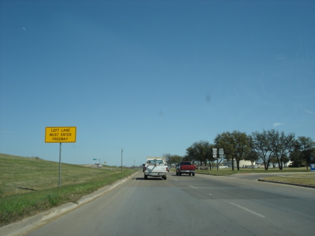
As we prepare to pass by the Chicken Express, Texas 114 prepares to depart the three federal highways. The road will then add one more federal highway to the mix, U.S. 82. U.S. 82 and U.S. 277 will duplex from Seymour to Wichita Falls. (Photo taken 3/18/05) |
 |
Continue north on U.S. 183 and U.S. 283 to visit Vernon. A left turn here on U.S. 82 and Texas 114 West will take motorists to Lubbock in about 160 miles. (Photo taken 3/18/05) |
 |
U.S. 183/U.S. 277/U.S. 283 North/TX 114 West at U.S. 82 and Texas 114 West. Regular unleaded gas was $2.09/gallon in Seymour on this March afternoon. (Photo taken 3/18/05) |
 |
U.S. 82 East, U.S. 183 North, U.S. 277 North, and U.S. 283 North assurance shields just north of U.S. 82 and Texas 114 West. This quadplex of U.S. highways is nine miles long. After that, the quadplex is split in half, as U.S. 183 and U.S. 283 North continue their duplex while U.S. 82 East and U.S. 277 North continue theirs. (Photo taken 3/18/05) |
 |
U.S. 82 East, U.S. 183 North, U.S. 277 North, and U.S. 283 North approaching Farm to Market Road 1919 North in north Seymour. For a town of just under 3,000, Seymour sure has its share of highways! (Photo taken 3/18/05) |
 |
U.S. 82 East, U.S. 183 North, U.S. 277 North, and U.S. 283 North at Farm to Market Road 1919 North. (Photo taken 3/18/05) |
 |
U.S. 82 East, U.S. 183 North, U.S. 277 North, and U.S. 283 North approaching Farm to Market Road 1790 South. The upcoming intersection also is the split of U.S. 183 and U.S. 283 from U.S. 82 and U.S. 277. (Photo taken 3/18/05) |
 |
U.S. 183 and U.S. 283 northbound traffic makes a left turn to continue to Vernon. U.S. 82 and U.S. 277 traffic continues northeastward to Wichita Falls. (Photo taken 3/18/05) |
 |
U.S. 82 East, U.S. 183 North, U.S. 277 North, and U.S. 283 North at U.S. 183/U.S. 283 North and Farm to Market Road 1790 South. A 34 mile drive separates this intersection from Vernon, population 11,660. (Photo taken 3/18/05) |
 |
U.S. 82 East and U.S. 277 North approaching Farm to Market Road 2846. (Photo taken 3/18/05) |
 |
U.S. 82 East and U.S. 277 North at Farm to Market Road 2846. This location is called Dundee, but we didn't see any signs of crocodiles. (Photo taken 3/18/05) |
 |
U.S. 82 East and U.S. 277 North approaching Farm to Market Road 368. (Photo taken 3/18/05) |
 |
U.S. 82 East and U.S. 277 North at Farm to Market Road 368 North. The highway begins by heading south, then turns to the east. Finally it curves back to the north, intersecting U.S. 82 and U.S. 277 a second time in Holliday, where it shares a short multiplex with the two U.S. highways. (Photo taken 3/18/05) |
 |
U.S. 82 East and U.S. 277 North approaching Texas 25. (Photo taken 3/18/05) |
 |
Electra is 19 miles to the north, and Archer City is 17 miles to the south. (Photo taken 3/18/05) |
 |
U.S. 82 East and U.S. 277 North at Texas 25. Beginning near the Red River, the state highway travels southward through Electra, and Archer City before ending at U.S. 281 in Windthorst. (Photo taken 3/18/05) |
 |
U.S. 82 East and U.S. 277 North at Farm to Market Road 368 North in Holliday. The city's population is 1,632 and is home to a Dairy Queen. (Photo taken 3/18/05) |
 |
U.S. 82 East, U.S. 277 North, and Farm to Market Road 368 South at FM 368 South. (Photo taken 3/18/05) |
 |
U.S. 82 East and U.S. 277 North approaching Farm to Market Road 440. (Photo taken 3/18/05) |
 |
U.S. 82 East and U.S. 277 North at Farm to Market Road 440. (Photo taken 3/18/05) |
 |
Only 14 miles to Wichita Falls! Henrietta, 35 miles ahead, is located along U.S. 82. The road widens to four lanes undivided for the trip to Wichita Falls. (Photo taken 3/18/05) |
 |
U.S. 82 East and U.S. 277 North approaching Texas 258. This marks the eastern terminus of the state highway that provides a shortcut from Texas 25 to Wichita Falls. (Photo taken 3/18/05) |
 |
U.S. 82 East and U.S. 277 North at Texas 258 West. The city limits of Wichita Falls are not too far away. (Photo taken 3/18/05) |
 |
U.S. 82 East and U.S. 277 North enter the city of Wichita Falls. With a population of just over 100,000 residents, the city is also home to the western terminus of Interstate 44. For more information on the city, visit the Wichita Falls Convention & Visitors Bureau website. The highway widens out just ahead to allow room for a future westward extension of the Kell Freeway. (Photo taken 3/18/05) |
 |
U.S. 82 East and U.S. 277 North approaching Farm to Market Road 369. FM 369 is the Southwest Parkway in Wichita Falls and sees its northern terminus at Texas 240 west of Burkburnett. (Photo taken 3/18/05) |
 |
U.S. 82 East and U.S. 277 North at Farm to Market Road 369. (Photo taken 3/18/05) |
 |
U.S. 82 East and U.S. 277 North approaching Business U.S. 277 and Farm to Market Road 2650. This is the final intersection before the beginning of the Kell Freeway. (Photo taken 3/18/05) |
 |
U.S. 82 East and U.S. 277 North at Business U.S. 277 North/Farm to Market Road 2650 South. (Photo taken 3/18/05) |
 |
U.S. 82 East and U.S. 277 North at the beginning of the Kell Freeway. At the present time, the freeway ends just shy of U.S. 287 near the western terminus of Interstate 44. (Photo taken 3/18/05) |
 |
U.S. 82 East and U.S. 277 North approaching Fairway Boulevard - 1/4 mile. Railroad tracks pass underneath the freeway here. (Photo taken 3/18/05) |
 |
U.S. 82 East and U.S. 277 North at Fairway Boulevard. (Photo taken 3/18/05) |
 |
Mileage sign on U.S. 82 East and U.S. 277 North at Fairway Boulevard. The next exit is one-half mile ahead, serving McNiel Avenue, Lawrence Road, and Lebanon Road. (Photo taken 3/18/05) |
 |
U.S. 82 East and U.S. 277 North approaching McNiel Avenue, Lawrence Road, and Lebanon Road - 1/4 mile. The freeway gains an extra eastbound lane from Fairway Boulevard. (Photo taken 3/18/05) |
 |
U.S. 82 East and U.S. 277 North at McNiel Avenue, Lawrence Road, and Lebanon Road. (Photo taken 3/18/05) |
 |
U.S. 82 East and U.S. 277 North approaching Kemp Boulevard - 1/2 mile. (Photo taken 3/18/05) |
 |
U.S. 82 East and U.S. 277 North at Kemp Boulevard. U.S. 281 and U.S. 287 are two miles ahead. (Photo taken 3/18/05) |
 |
U.S. 82 East and U.S. 277 North at Taft Boulevard and Harrison Street. (Photo taken 3/18/05) |
 |
U.S. 82 East and U.S. 277 North approaching Brook Avenue - 1/2 mile, and U.S. 281/U.S. 287 - 1 mile. The first sign of the impending end of the freeway also appears here. (Photo taken 3/18/05) |
 |
U.S. 82 East and U.S. 277 North at Brook Avenue. The four eastbound lanes seen here will be squeezed into two lanes within the next quarter-mile. (Photo taken 3/18/05) |
 |
Now down to just two lanes, the freeway concludes as traffic is shunted onto the frontage roads. Stay to the left to get onto U.S. 277/U.S. 281/U.S. 287 North and Interstate 44 East. Stay to the right to continue on U.S. 82 East, which becomes multiplexed with U.S. 281 and U.S. 287 South. (Photo taken 3/18/05) |
 |
As traffic merges onto the frontage road, two extra lanes become available. Merge to the right to stay on U.S. 82. (Photo taken 3/18/05) |
 |
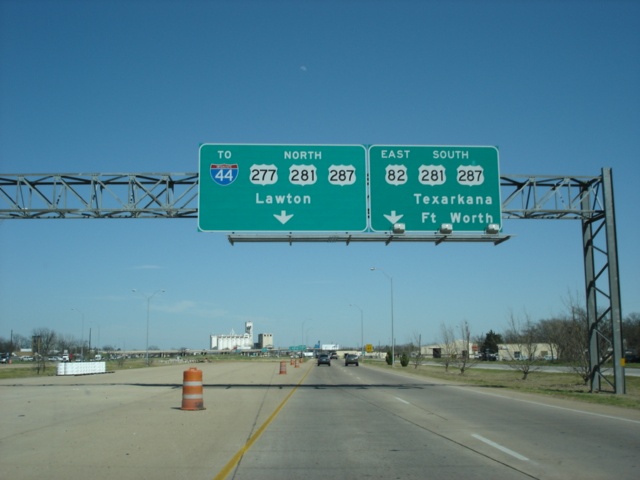
U.S. 82 East and U.S. 277 North at U.S. 82 East/U.S. 281 South/U.S. 287 South - Texarkana/Fort Worth. Texarkana is used as a control city instead of Gainesville or Sherman, which we believe are better candidates, considering that Texarkana is still 272 miles away. Fort Worth, on the other hand, is just 104 miles away via U.S. 287 South. (Photo taken 3/18/05) |
 |
The left two lanes are allowed to turn onto U.S. 277 North. Traffic will use the freeway's frontage roads for a mile before merging onto the freeway. At that point, Interstate 44 East begins. Straight ahead is the eastbound beginning of Spur 447, connecting U.S. 277/U.S. 281/U.S. 287 to Texas 240. (Photo taken 3/18/05) |
 |
U.S. 277 North at U.S. 82 West and U.S. 277 South - Abilene/Lubbock. (Photo taken 3/18/05) |
 |
U.S. 281 and U.S. 287 northbound assurance shields on U.S. 277 North. Those two highways travel along the viaduct in this view. Eventually, though, we will be on U.S. 281 and U.S. 287 North, along with Interstate 44 East. (Photo taken 3/18/05) |
 |
Use the center lane to merge onto Interstate 44 East. This is the first sign of the ramp's departure. (Photo taken 3/18/05) |
 |
U.S. 277 North at 10th Street. The viaduct carries northbound traffic on U.S. 281 and U.S. 287 over downtown Wichita Falls. It was completed during the summer of 2001 and provides a connection between two freeways: Interstate 44 and U.S. 281/U.S. 287. Previously, all traffic between those two freeways were forced onto these frontage roads. (Photo taken 3/18/05) |
 |
U.S. 277 North at Interstate 44 East/U.S. 277/U.S. 281 North. But not so fast, as there is one more stoplight between here and the on-ramp. Continue straight ahead on the frontage road to Business U.S. 277. U.S. 277 and U.S. 281 will run along Interstate 44 for 19 miles until their departure from the interstate at Exit 5 in Oklahoma. (Photo taken 3/18/05) |
| Scenes Related to U.S. 277 | |
 |
Texas 6 North at U.S. 277 North in Stamford. The northbound beginning of Texas 283 also takes place here. (Photo taken 3/18/05) |
Page created: July 02, 2005
Last updated:
July 03, 2005