 |
Home Search OKRoads:
|
|
|
Home Search OKRoads:
|
Spring Break 2002 Roadtrip:
Oklahoma's Turnpikes Begin to End
March 18-22, 2002
This was the roadtrip that began it all! During my Spring Break from college in my freshman year, I decided to take a roadtrip that would allow me to drive all 10 turnpikes in the state of Oklahoma from beginning to end. And except for the 8-mile Stillwater spur of the Cimarron Turnpike, I was able to drive and see every mile of Oklahoma's turnpikes in five days! (At least, the parts that were complete at that time.) The trip was broken up into three parts:
Part 1 (March 18-19)
Drove the Turner, Will Rogers, Cherokee, Muskogee, Creek, Cimarron, and Kilpatrick turnpikes.
Route: I-35 --> I-44 --> U.S. 71 --> MO/AR 59 --> U.S. 412 --> I-540 --> I-40 --> Muskogee Tpk. --> Creek Tpk. --> I-44 --> OK 97 --> U.S. 412 --> I-35 --> Kilpatrick Tpk. --> I-40 --> I-44 --> Home
794 miles total
Overall the trip was 1,505 miles long, and it was mostly around the state of Oklahoma! I also spent time in Kansas, Missouri, Arkansas, and Texas, however, I spent longer in Texas than originally planned.
Since these were the first ever road sign pictures I took, period, they were with a non-digital camera, and some of them were in terrible weather, I am not posting the pictures here. In the three years since this trip, I have revisited nearly all of the places I went here, so any picture I took during this trip has been retaken one time or another since, with only a couple of exceptions. The turnpikes and other highways driven in Oklahoma are covered in greater detail at OKHighways.com, while Interstate 540 and AR/MO 59 have pages at OKRoads with pictures that I took during a visit in 2004.
Maps of Trip Route
Part 1:

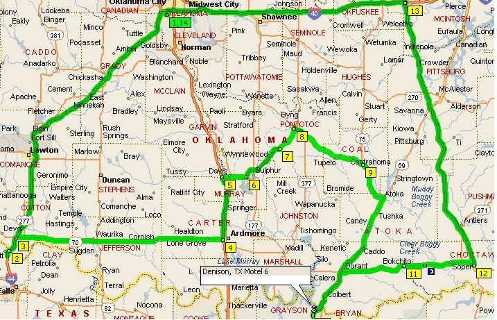
Part 2:
Trip Summary:
The main story of the first part of this trip was the weather. It was absolutely miserable, and it was obvious in most of the pictures. It's tough driving 75 mph in rain and trying to take a picture of a road sign at the same time, especially when this was the first time I had ever done so! I almost lost control of my car at one point near Tulsa, and needless to say I learned my lesson and had no other close calls for the rest of the week! But the picture actually turned out OK. It rained the whole distance except the time between Tulsa and the Arkansas-Missouri state line on Monday and between around Hallett and home on Tuesday.
The trip began familiarly enough as I drove two turnpikes I've driven several times before-the Turner and Will Rogers turnpikes. Then after going into Missouri on I-44, I took the first exit, went about 1000 feet to the northwest to get a picture of the Welcome to Kansas sign, went back on I-44 East for 10 miles, then after I got off on the recently-built U.S. 71 freeway it was unfamiliar territory for me from that point on.
Southwest Missouri had the most beautiful scenery of the trip, especially the drive along MO 59. At some points (didn't get any pictures, sorry!) there was a rock hanging over you while a creek ran down the other side. The rain hadn't started back quite yet so I got to see it pretty well.
My hotel accommodations for this part was the Motel 6 (the official hotel of OKRoads.com!) of Fayetteville, Arkansas. It was an all right hotel and got even better once I put the cable back into the TV and I got like 40 channels! Last year I stayed at Motel 6's in Texas and Missouri and the most channels I got on a TV there was 12, so this was quite a shock for me! (As I found later in the week, there are Motel 6's out there with 60+ TV channels!)
Tuesday I drove the also recently-built Interstate 540 between Fayetteville and I-40, which along with the U.S. 71 freeway in Missouri I had drove on the day before could someday be part of Interstate 49. Some of the most heavy rain of the trip, unfortunately, had to happen during this part so I didn't get any good pictures. The Bobby Hopper Tunnel was pretty cool-it was a temporary relief from the rain!
I drove over the Arkansas River bridge on I-40 just before getting on the Muskogee Turnpike. Yes it is the same bridge that collapsed in late May 2002 which caused havoc in eastern Oklahoma for two months while the bridge was replaced. It was just one of five times I crossed the Arkansas River on Tuesday! The rain continued falling until about 10 miles into the Cimarron Turnpike, then it stopped. It did sprinkle a little bit once I got on the Kilpatrick Turnpike in Oklahoma City, but I'd already been on the turnpike before and it was just sprinkles anyways.
Part 1.5 was barely a part at all. It only lasted about 60 miles, it covered a 10-mile spur of turnpike near my house, and I drove it in about 20 minutes, if even that long. The weather for this day was the best of the week, as it was sunny and in the upper 50's to lower 60's. No hotels were necessary since I was right by home. This day also goes down in history as the day that I found out I was becoming a church bus captain. It didn't happen for another two years after this meeting, but that meant I had plenty of time to prepare.
Part 2 started out cold and windy. There was no precipitation falling from the sky, but when I left home the temperature was 45 degrees with a wind chill in the mid teens. When I gassed up my car about 30 miles into the day, I thought my hat would blow away and my hands would fall off because of numbness. Plus, the @&$^ credit card thing at the gas pump wouldn't work! So I didn't necessarily get a good start to this part. Things did get better, though. The weather improved, and even though it was still cold, it was sunny.
Thursday was what I called U.S. 70 Day. I drove that highway (mostly 2-lane road) between I-44 and I-35, a distance of about 100 miles. I was glad when the road widened to 4-lane divided highway near the end!
This was also the day I drove the absolutely most worthless turnpike in Oklahoma, the Chickasaw Turnpike. It's a two-lane road, for crying out loud! And you have to pay 55 cents to drive on it! The last few miles aren't freeway at all, it's just a normal two-lane road! I didn't even take any pictures of it besides the termini because it was so pathetic! Another sad thing is that the road leading to the turnpike is 4-lane, divided highway, 70 mph speed limit, and free to drive on, and the turnpike is a 2-lane road with a 65 mph speed limit and a 55 cent charge!
Now comes the fun story. I had planned on staying the night at a Best Western in Durant. I got there about 3:45 or so and went to check in. Well come to find out they couldn't give me a room because I was not 21 years old at that time. (And I wasn't until July 12, 2004!) So I told them to cancel my reservation and I check the other three hotels in town. They all said no too. So I was very ticked off and went in a huff to Denison, Texas, about 20 miles south of Durant, and ran a stoplight with cameras in the process. I thought I was gonna get a love letter from the Durant P.D. but I haven't heard nothing yet and it's been three years! I ended up staying at yet another Motel 6 and it ended up being a cheaper room, but a nicer hotel. This hotel was the nicest Motel 6 I think I've ever seen. It was built just three years ago and had a nice interior corridor and great rooms. And they let me sleep there, which was the best part of all! Oh yeah, and the TV had over 60 channels of cable on it! I think there were 4 Spanish channels! Si! Muy bueno, senor. Que? Back to Durant, I hate that town! They have cameras at every stoplight, a cement truck I was behind got me lost and I had to turn around, and none of the hotels would take me! But on the outskirts of town there was an Independent, fundamental Baptist church, so at least they might have a good gospel witness there. I hope so, they need it! But I was glad to get out of that town! Plus their paper is called the Democrat, how bad can you get! ;)
Friday was the final day of the trip and I drove the longest turnpike in Oklahoma, the 105-mile Indian Nation Turnpike. It was during my drive on this turnpike that I came up with the original plan for the Plains & Panhandles Roadtrip, which was be July 8-11. No real highlights on this day, just the sadness that this trip was over and I had to go back to college on Monday!
Page created: January 22, 2005
Last updated:
January 23, 2005