
DELAWARE
STATE HIGHWAY
TERMINUS GALLERY & GUIDES
Highway
Review:
DE 54 spends about ten miles straddling the southern border
between Maryland and Delaware. Parts of eastbound DE 54 run in
the Old Line State, and some MD 54 signs do exist along the
stretch. After joining DE 26 near Gumboro, the highway leaves
Maryland behind for good, but does remain within a couple miles
of the state for the rest of its route. It ends duplexed with DE
20 at DE 1 in Fenwick Island. On an unrelated note, DE 54 is also
the highway that takes me to the main reason why I have these
pictures in the first place!
Highway
Information:
Distance: 38.5 miles
Counties traveled through: Sussex
Highway intersections: MD 675 (Mile 6.7), U.S. 13 (Mile 7.5), DE
26 (Mile 16.5), DE 30 (Mile 17.3), DE 26/30 (Mile 18.9), U.S. 113
(Mile 27.3), DE 17 (Mile 28.3), DE 20 (Mile 34.5), DE 1 (Mile
38.5)
Highway duplexes: DE 26 (Miles 16.5-18.9, 2.4 miles), DE 30
(Miles 17.3-18.9, 1.6 miles), DE 20 (Miles 34.5-38.5, 4.0 miles)
WESTERN
TERMINUS
Maryland State Line,
continues as MD 54
 |
"Welcome to
Maryland" sign as MD 54 begins. There is no
"END" sign at this terminus. The Mason-Dixon monument is just ahead. It is on the north (right) side of the highway, just to the right of the sign, where the small white poles lie in a half-circle. (Photo taken 3/20/03) |
OTHER HIGHWAY PICTURES
 |
DE 54 East at U.S. 13 in Delmar. A right turn will put motorists
into the state of Maryland. (Photo taken 3/17/03) |
 |
DE 54 West at U.S. 13 in Delmar. (Photo taken 3/17/03) |
 |
Another view of DE 54 West at U.S. 13, as seen four and a half months later. (Photo taken 8/6/03) |
 |
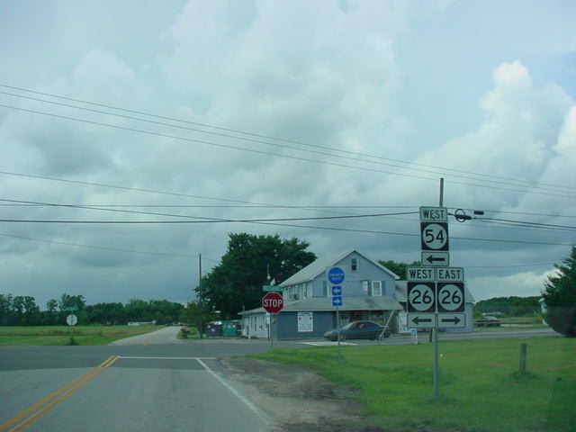
MD 54 West
assurance shield just west of DE 26/MD 353.
The highway runs directly along the state line for the next ten miles. Appropriately, the road is called Line Rd. (Photo taken 3/17/03) |
 |
"END DE
26" sign as DE 26/54 prepare to enter Maryland. DE
54 does turn right at the intersection just ahead. Right after making the right turn, the MD 54 shield pictured above is seen. (Photo taken 3/17/03) |
 |
Another view of the western terminus of DE 26, as seen four and a half months later. (Photo taken 8/3/03) |
 |
DE 26/54 West
assurance shields just southwest of DE 30 West. (Photo taken 3/17/03) |
 |
DE 26/30/54 West at
DE 30 West. The three highways have a 1.6 mile duplex near the town of Gumboro. (Photo taken 3/17/03) |
 |
Another view of the departure of DE 30 West from the triplex, as seen four and a half months later. (Photo taken 8/3/03) |
 |
DE
26/DE 30/DE 54 East assurance shields just north of DE 30 West. (Photo taken 8/3/03) |
 |
DE 26/30/54 West
assurance shields south of DE 54. (Photo taken 3/17/03) |
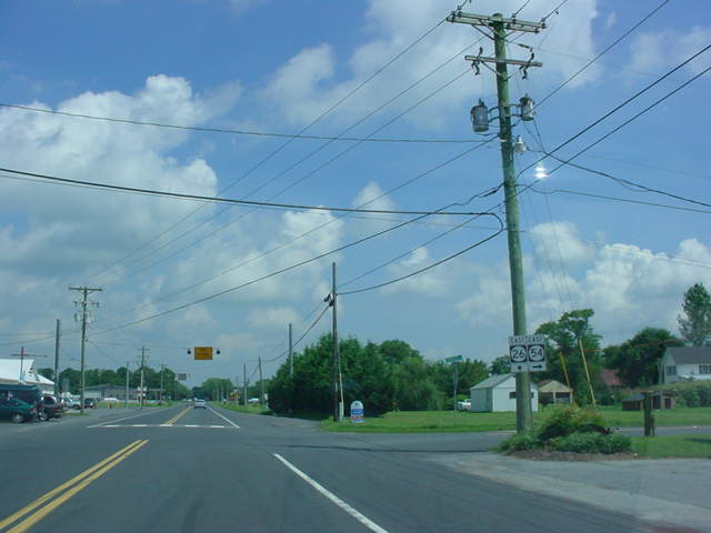 |
DE
26/DE 30/DE 54 East at DE 54 East. Notice the lack of assurance signage for DE 30 at this intersection. (Photo taken 8/3/03) |
 |
DE 54 West at DE 26
in Gumboro. Once again, DE 30 is left off the signs, even though the highway duplexes with DE 26 here. (Photo taken 3/17/03) |
 |
Another view of DE 54 West at DE 26/DE 30, as seen four and a half months later. (Photo taken 8/3/03) |
 |
DE
54 cuts through the Cypress Swamp between Gumboro and Selbyville. This picture shows a typical view of this tree-lined stretch of highway. (Photo taken 8/3/03) |
 |
DE 54 West
assurance shield and straight arrow just west of U.S. 113. The highway winds through the Cypress Swamp between DE 26/30 and U.S. 113. (Photo taken 3/17/03) |
 |
DE 54 West at U.S.
113 in Selbyville. U.S. 113 connects Pocomoke City, Maryland, to Milford. (Photo taken 3/18/03) |
 |
Another view of DE 54 West at U.S. 113, as seen four and a half months later. (Photo taken 8/3/03) |
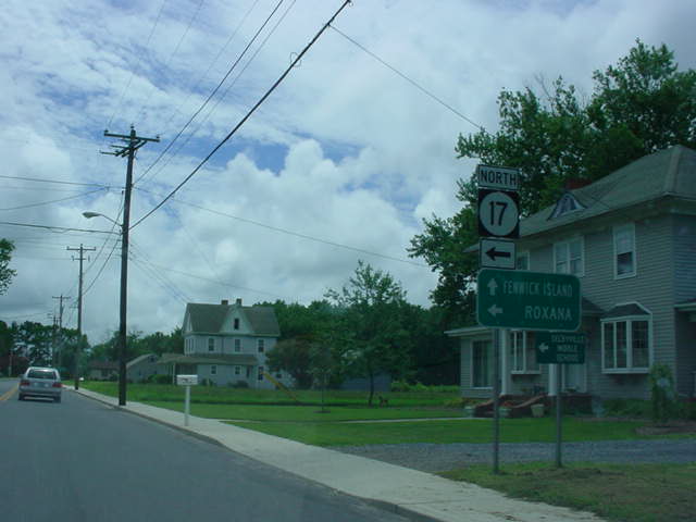 |
DE
54 East at DE 17 North in Selbyville. DE 17
connects to Millville and DE 26 at its other end. (Photo taken 8/3/03) |
 |
DE 20/DE 54 West at DE 20 West. The intersection
is the western end of this highway duplex that lasts four miles. It is the final miles for both highways, with their joint eastern terminus at DE 1 in Fenwick Island. (Photo taken 8/3/03) |
EASTERN
TERMINUS
DE 1, Fenwick Island
 |
DE
20/DE 54 East at DE 1. There is no "END" signs at this terminus for either route. (Photo taken 8/3/03) |
 |
DE 20/54 West
assurance shields west of DE 1. The highways are duplexed for four miles before splitting west of Fenwick Island. (Photo taken 3/18/03) |
 |
Another view of the first
westbound assurance shields, as seen four and a half months later. (Photo taken 8/3/03) |
 |
DE 1 North at DE 20/DE 54 West. (Photo taken 8/3/03) |
 |
DE
1 South at DE 20/54 West in Fenwick Island. For those continuing straight ahead, they will enter Maryland and Ocean City in less than 1/4 mile. (Photo taken 3/18/03) |
 |
Another view of DE 1 South at DE
20/DE 54 West, as seen four and a half months later. (Photo taken 8/3/03) |
OKRoads.com Home --> Delaware Highway Guides --> Delaware State Highway Terminus Gallery & Guides