OKRoads.com
Delaware State Highway
Terminus Gallery & Guides
Delaware State Highway Ends - Delaware 30 @ AARoads.com
Oklahoma State Highway
Terminus
Gallery & Guides
Delaware State Highway
Terminus Gallery & Guides
Roadtrips:
Spring Training 2004
Roadtrip
Coming soon!
Seattle Trip
Coming soon!
Other Pages
DELAWARE
STATE HIGHWAY
TERMINUS GALLERY & GUIDES
![]()
Highway
Review:
DE 30 spans 44 miles throughout Sussex County. It runs east-west
for its first 10 miles, then goes north-south for the remaining
34 miles. Despite its distance, the highway travels directly
through just one town, Millsboro.
Highway
Information:
Distance: 44.4 miles
Counties traveled through: Sussex
Highway intersections: U.S. 13 (Mile 0.5), DE 26/54 (Mile 10.7),
DE 54 (Mile 12.3), DE 26 (Mile 15.6), DE 24 (Mile 16.5), U.S.
113/DE 20 (Mile 21.5), DE 24 (Mile 22.3), U.S. 9 (Mile 30.7), DE
16 (Mile 36.1), DE 1 (Mile 44.4)
Highway duplexes: DE 54 (Miles 10.7-12.3, 1.6 miles), DE 26
(Miles 10.7-15.6, 4.9 miles), DE 24 (Miles 16.5-22.3, 5.8 miles)
WESTERN
TERMINUS
Delmar Rd.
 |
"END DE
30" sign at Delmar Rd. Most maps think that U.S. 13
is the western terminus of DE 30, and common sense would think that it is. But the highway goes half a mile west of U.S. 13 to end at Delmar Rd. (Or Bi-State Blvd., as it is called in Delmar) (Photo taken 3/18/03) |
 |
DE 30 East
assurance shield just east of Delmar Rd. (Photo taken 3/18/03) |
OTHER HIGHWAY PICTURES
 |
DE 30 East
assurance shield just east of U.S. 13. The highway's next intersection is DE 26/54 in ten miles. (Photo taken 3/18/03) |
 |
DE 30 West
approaching U.S. 13. There is no signage for the highway at the actual intersection. (Photo taken 3/18/03) |
 |
DE 30 West
assurance shield just west of U.S. 13. The highway comes to an end in half a mile. (Photo taken 3/18/03) |
 |
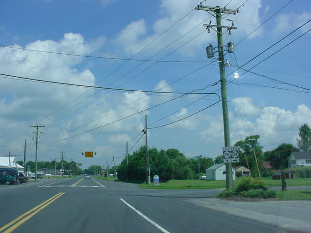
DE 30 East at DE 26/DE 54 near
Gumboro. (Photo taken 8/3/03) |
 |
DE 26/30/54 West at
DE 30 West south of Gumboro. The three highways are triplexed for slightly over 1.5 miles. (Photo taken 3/17/03) |
 |
Another view of DE 26/DE 30/DE 54
West at DE 30 West, as seen four and a half months later. (Photo taken 8/3/03) |
 |
DE 26/DE 30/DE 54 East assurance
shields just north of DE 30 West. (Photo taken 8/3/03) |
 |
Small assurance
shields for DE 26/30/54 West are seen here just to the south of DE 54. (Photo taken 3/17/03) |
 |
DE 26/DE 30/DE 54 East at DE 54
East in Gumboro. (Photo taken 8/3/03) |
 |
DE 26/DE 30 East at DE 26 East. DE
30 continues straight ahead and will intersect DE 24 in less than a mile. (Photo taken 8/3/03) |
 |
DE 30 West at DE 26 East. (Photo taken 8/4/03) |

|
DE
24/DE 30 West at DE 24 West. (Top photo taken 8/4/03, bottom photo taken 8/5/03) |
 |
DE 30 North at Alternate DE 5 near Milton. (Photo taken 8/5/03) |
 |
DE
30/Alternate DE 5 North at DE 16. This is the northern terminus of Alternate DE 5. There is no "END" sign at this terminus for that route. DE 30 continues ahead for another eight miles before ending at DE 1 in Milford. (Photo taken 8/5/03) |

NORTHERN
TERMINUS
DE 1, east of Milford
 |
"END DE 30" sign as the
highway comes to an end in Milford. The road becomes Business DE 1. The embankment to the right connects Business DE 1 South to DE 1 South. (Photo taken 8/5/03) |
 |
DE 30/Business DE 1
South assurance shields as DE 30 begins. Business DE 1 lasts for just a few more feet before ending at the on-ramp to DE 1 South. (Photo taken 8/5/03) |