 |
Home Search OKRoads:
|
|
|
Home Search OKRoads:
|
Interstate 10 Louisiana
Eastbound
|
Highway Information |
|
| Miles | 274.42 |
| Parishes Traveled Through |
Calcasieu, Jefferson Davis, Acadia, Lafayette, St. Martin, Iberville, West Baton Rouge, East Baton Rouge, Ascension, St. James, St. John the Baptist, Jefferson, Orleans, St. Tammany |
| Cities | Lake Charles, Lafayette, Baton Rouge, Kenner, New Orleans |
| Major Junctions | Interstate 210 (Exit 25, Exit 34)
Interstate 49 Interstate 110 Interstate 12 Interstate 55 Interstate 310 Interstate 610 Interstate 510 Interstate 59 |
| OKRoads Coverage | |
| Miles Driven by OKRoads (Percentage) |
274 (100%) |
| Western End of Interstate Driven |
Texas State Line |
| Eastern End of Interstate Driven |
Mississippi State Line |
Pictures
Westbound from Interstate 12/Interstate 59 to Interstate 55
 |
The first exit in Louisiana on
Interstate 10 East is at Exit 4 - U.S. 90/LA 109 - Toomey/Sparks. (Photo taken 12/17/02) |
 |
Interstate 10 East at Exit 7 - LA
3063 - Vinton. More construction in this area gave me
an opportunity to get closer signage at 45 mph than I
probably would've got at 70 mph. (Photo taken 12/17/02) |
 |
Interstate 10 East at Exit 8 - LA
108 - Vinton. (Photo taken 12/17/02) |
 |
Interstate 10 East at Exit 20 - Business LA 27 -Sulphur/Cameron. (Photo taken 12/17/02) |
 |
Interstate 10 East at Exit 21 - LA
27 - DeQuincy. (Photo taken 12/17/02) |
 |
Interstate 10 East at Exit 23 - LA
108 - Industries/ Sulphur. Lake Charles is just a couple
miles away at this point. (Photo taken 12/17/02) |
 |
Interstate 10 East approaching
Exit 25 - Interstate 210 - 1 1/4 miles. Interstate 210 is Interstate
10's loop into Lake Charles. (Photo taken 12/17/02) |
 |
Interstate 10 East approaching Exit 25 - 1/2 mile. (Photo taken 12/17/02) |
 |
Interstate 10 East at Exit 25 - Interstate 210 East -Lake Charles Loop. (Photo taken 12/17/02) |
 |
Interstate 10 East at Exit 26 - PPG Drive. (Photo taken 12/17/02) |
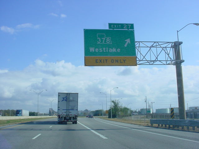 |
Interstate 10 East at Exit 27 - LA 378 - Westlake. (Photo taken 12/17/02) |
 |
Interstate 10 East approaching Exit 29 - LA 385 - 2 miles. This gantry is at the west end of the approach to the bridge. (Photo taken 12/17/02) |
 |
View of Lake Charles from the top of the bridge pictured above. (Photo taken 12/17/02) |
 |
Interstate 10 East at Exit 29 - LA 385 - Downtown Area. (Photo taken 12/17/02) |
 |
Interstate 10 East at Exit 31A - Business U.S. 90 -Enterprise Blvd. (Photo taken 12/17/02) |
 |
Interstate 10 East at Exit 31B - U.S. 90 East TO LA 14. (Photo taken 12/17/02) |
 |
Interstate 10 East at Exit 32 - Opelousas St. in Lake Charles. (Photo taken 12/17/02) |
 |
Interstate 10 East at Exit 33 - U.S. 171 North -DeRidder/Shreveport. (Photo taken 12/17/02) |
 |
Interstate 10 East approaching Exit 34 - Interstate 210 West - 1/2 mile. (Photo taken 12/17/02) |
 |
Interstate 10 East at Exit 34 - Interstate 210 West. (Photo taken 12/17/02) |
 |
Interstate 10 East at Exit 36 - LA 397 -Creole/ Cameron. (Photo taken 12/17/02) |
 |
Interstate 10 East at Exit 43 - LA 383 - Iowa. (Photo taken 12/17/02) |
 |
Interstate 10 East at Exit 44 - U.S. 165 - Alexandria. (Photo taken 12/17/02) |
 |
Interstate 10 East at Exit 48 - LA 101 - Lacassine. (Photo taken 12/17/02) |
 |
Interstate 10 East at Exit 54 - LA 99 - Welsh. (Photo taken 12/17/02) |
 |
Interstate 10 East at Exit 59 - LA 395 - Roanoke. (Photo taken 12/17/02) |
 |
Interstate 10 East at Exit 64 - LA 26 - Elton/Jennings. (Photo taken 12/17/02) |
 |
Interstate 10 East at Exit 65 - LA 97 - Jennings/ Evangeline. (Photo taken 12/17/02) |
 |
Interstate 10 East at Exit 72 - Egan. (Photo taken 12/17/02) |
 |
Interstate 10 East at Exit 76 - LA
91 - Iota/ Estherwood. (Photo taken 12/17/02) |
 |
Interstate 10 East at Exit 80 - LA 13 - Eunice/Crowley. (Photo taken 12/17/02) |
 |
Interstate 10 East at Exit 87 - LA 35 - Church Point/Rayne. (Photo taken 12/17/02) |
 |
Interstate 10 East at Exit 92 - LA 95 - Mire/Duson. (Photo taken 12/17/02) |
 |
Interstate 10 East at Exit 97 - LA 93 - Cankton/Scott. (Photo taken 12/17/02) |
 |
Interstate 10 East at Exit 100 - Ambassador Caffery Pkwy. (Photo taken 12/17/02) |
 |
Interstate 10 East at Exit 101 - LA 182 - Lafayette/Carencro. (Photo taken 12/17/02) |
 |
Interstate 10 East approaching Exits 103A-B - Interstate 49/U.S. 167 - 3/4 mile. (Photo taken 12/17/02) |
 |
Interstate 10 East at Exit 103A - U.S. 167 South to U.S. 90 - Lafayette. (Photo taken 12/17/02) |

|
Interstate 10 East at Exit 103B - Interstate 49/U.S. 167 North - Opelousas. Interstate 49 currently finds its southern terminus here, but is slated to be extended down U.S. 167 and U.S. 90 to New Orleans. (Top photo taken 12/17/02, bottom photo taken 12/13/03) |
 |
Interstate 10 East at
unmarked Exit 105 - Louisiana Ave. This interchange was built during 2003, and at the time I took this picture, Louisiana Ave. was incomplete except for this interchange. (Photo taken 12/13/03) |

|
Interstate 10 East at Exit 109 - LA 328 - Breaux Bridge. (Top photo taken 12/17/02, bottom photo taken 12/13/03) |

|
Interstate 10 East at Exit 115 - LA
347 -Cecilla/ Henderson. This is the last exit before the 16-mile long bridge over the Atchafalaya Swamp area begins. (Top photo taken 12/17/02, bottom photo taken 12/13/03) |
 |
Interstate 10 East at
the beginning of the Atchafalaya Swamp Freeway. For about 15 miles, this viaduct carries Interstate 10 traffic over swamplands. The speed limit is 60 during this stretch, but nobody goes that speed. (Photo taken 12/13/03) |
 |
Interstate 10 East on the bridge over the swamplands. (Photo taken 12/17/02) |

|
Interstate 10 East as it crosses the Henderson Swamp on the same bridge. (Top photo taken 12/17/02, bottom photo taken 12/13/03) |

|
Interstate 10 East at Exit
121 - Butte La Rose. This interchange is elevated over the same swamplands in the last couple pictures. (Top photo taken 12/17/02, bottom photo taken 12/13/03) |

|
Interstate 10 East at Exit 127 - LA
975 - Whiskey Bay. This interchange is also located on the same viaduct. (Top photo taken 12/17/02, bottom photo taken 12/13/03) |
 |
Interstate 10 East at
Exit 135 - LA 3000. Okay, so this is a blank sign gantry. But the exit ramp is for LA 3000. This marks the eastern end of the viaduct, and one may now go 70 mph legally, even though other motorists have probably been going about 90 mph. (Photo taken 12/13/03) |

|
Interstate 10 East at Exit 139 - LA 77 -Rosedale/Grosse Tete. This is the first exit on solid ground since Exit 115. (Top photo taken 12/17/02, bottom photo taken 12/13/03) |

|
Interstate 10 East at Exit 151 - LA 415/TO U.S. 190 - Lobdell. Notice the odd-looking LA 415 shield on this sign. It looks like Louisiana is scrunched into the sign slightly. (Top photo taken 12/17/02, bottom photo taken 12/13/03) |

|
Interstate 10 East at Exit 153 - LA
1 - Port Allen/ Plaquemine. The bridge in the distance takes motorists over the Mississippi River and into Baton Rouge, the capital of Louisiana. (Top photo taken 12/17/02, bottom photo taken 12/13/03) |

|
Interstate 10 East approaching Exit 155B - Interstate 110 - 2 miles. This sign gantry is on the approach to the Mississippi River bridge. (Top photo taken 12/17/02, bottom photo taken 12/13/03) |

|
Interstate 10 East as it goes over the Mississippi River. (Top photo taken 12/17/02, bottom photo taken 12/13/03) |

|
Interstate 10 East approaching Exit 155B - 1 mile. The city of Baton Rouge is also seen in this view from the top of the Mississippi River bridge. (Top photo taken 12/17/02, bottom photo taken 12/13/03) |

|
Interstate 10 East at Exit 155A - LA 30 - To LSU/Nicholson Dr./Highland Rd. (Top photo taken 12/17/02, bottom photo taken 12/13/03) |

|
Interstate 10 East approaching Exit 155B - 1/2 mile. (Top photo taken 12/17/02, bottom photo taken 12/13/03) |

|
Interstate 10 East at Exit 155B - Interstate 110 North -Bus. District/Metro Airport. (Top photo taken 12/17/02, bottom photo taken 12/13/03) |

|
Interstate 10 East at Exit 156A - Washington St. (Top photo taken 12/17/02, bottom photo taken 12/13/03) |

|
Interstate 10 East at Exit 156B - Dalrymple Dr./LSU. (Top photo taken 12/17/02, bottom photo taken 12/13/03) |

|
Interstate 10 East at Exit 157A - Perkins Rd. (Top photo taken 12/17/02, bottom photo taken 12/13/03) |

|
Interstate 10 East at Exit 157B - Acadian Thwy. (Top photo taken 12/17/02, bottom photo taken 12/13/03) |
|
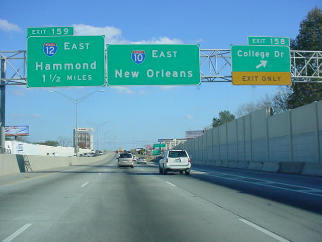
Interstate 10 East at Exit 158 - College Dr. (Top photo taken 12/17/02, bottom photo taken 12/13/03) |

|
Interstate 10 East approaching Exit 159 - Interstate 12 East - 3/4 mile. Interstate 12 is an 85-mile alternate route for traffic traveling on Interstate 10 that doesn't want to travel through New Orleans. (Top photo taken 12/17/02, bottom photo taken 12/13/03) |
|
Interstate 10 East approaching Exit 159 - 1/2 mile. (Top photo taken 12/17/02, bottom photo taken 12/13/03) |

|
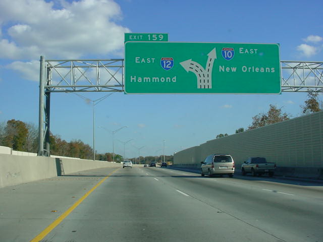
Interstate 10 East at Exit 159 - Interstate 12 East. Interstate 10 heads southeast at this point as it makes its way towards New Orleans. Hammond is about 35 miles away from this interchange. (Top photo taken 12/17/02, bottom photo taken 12/13/03) |
 |
Interstate 10 East at
Exit 160 - LA 3064 - Essen Lane. (Photo taken 12/13/03) |
 |
Interstate 10 East at
Exit 162 - Bluebonnet Rd. (Photo taken 12/13/03) |
 |
Interstate 10 East at Exit 163 - Siegen Lane. (Photo taken 12/13/03) |
 |
Interstate 10 East at
Exit 166 - LA 42/LA 427 - Highland Rd./Perkins Rd. (Photo taken 12/13/03) |
 |
Interstate 10 East at
Exit 173 - LA 73 - Prairieville/Geismar. (Photo taken 12/13/03) |
 |
Interstate 10 East at
Exit 177 - LA 30 - Gonzales/St. Gabriel. There is a Tanger Outlet Mall at this interchange. (Photo taken 12/13/03) |
 |
Interstate 10 East at
Exit 179 - LA 44 - Gonzales/Burnside. (Photo taken 12/13/03) |
 |
Interstate 10 East at
Exit 182 - LA 22 - Sorrento/Donaldsonville. (Photo taken 12/13/03) |
 |
Interstate 10 East at
Exit 187 - U.S. 61 South - Gramercy. (Photo taken 12/13/03) |
 |
Interstate 10 East at
Exit 206 - LA 3188 South - LaPlace. (Photo taken 12/13/03) |
 |
Interstate 10 East
approaching Exit 209 - U.S. 51/TO Interstate 55 North - 1 1/2 miles. (Photo taken 12/13/03) |
 |
Interstate 10 East
approaching Exit 209 - 1 mile. (Photo taken 12/13/03) |
 |
Interstate 10 East
approaching Exit 209 - 1/2 mile. (Photo taken 12/13/03) |
 |
Interstate 10 East at
Exit 209 - U.S. 51/TO Interstate 55 North - Hammond/LaPlace. (Photo taken 12/13/03) |
 |
Interstate 10 East as it
prepares to go underneath Interstate 55. This marks the southern terminus of Interstate 55. (Photo taken 12/13/03) |
 |
Interstate 10 East near
the end of Interstate 55. This viaduct is the longest continuous viaduct in the world. It is made up of the first 23 miles of Interstate 55, and about 10 miles of Interstate 10. (Photo taken 12/13/03) |
 |
Interstate 10 East as it
prepares to cross Lake Pontchartrain for the first time. This part of the lake is also called the Bonnet Carre Spillway. (Photo taken 12/13/03) |
 |
Interstate 10 East
approaching Exit 220 - Interstate 310 South - 2 miles. Unfortunately, it began to sprinkle just enough here to mess up the pictures, and the moisture didn't stop for the rest of this day. (Photo taken 12/13/03) |
 |
Interstate 10 East
approaching Exit 220 - 1 mile. (Photo taken 12/13/03) |
 |
Interstate 10 East
approaching Exit 220 - 1/2 mile. (Photo taken 12/13/03) |
 |
Interstate 10 East at
Exit 220 - Interstate 310 South - Boutte/Houma. (Photo taken 12/13/03) |
 |
Interstate 10 East at Exit 221 - Loyola Drive. (Photo taken 12/13/03) |
 |
Interstate 10 East at
Exit 223A-B - LA 49 - Williams Blvd./New Orleans International Airport. (Photo taken 12/13/03) |
 |
Interstate 10 East at
Exit 225 - Veterans Blvd. (Photo taken 12/13/03) |
 |
Interstate 10 East at
Exit 226 - Clearview Pkwy./Huey Long Bridge. (Photo taken 12/13/03) |
 |
Interstate 10 East at
Exit 228 - Causeway Blvd./Mandeville/Bonnabel Blvd. (Photo taken 12/13/03) |
 |
Interstate 10 East at
Exit 229 - Bonnabel Blvd. Interstate 610 is 1 1/2 miles ahead. (Photo taken 12/13/03) |
 |
Interstate 10 East
approaching Interstate 610 - 3/4 mile. (Photo taken 12/13/03) |
 |
Interstate 10 East
approaching Exit 230 - Interstate 610 East - 1/4 mile. (Photo taken 12/13/03) |
 |
Interstate 10 East at
Exit 230 - Interstate 610 East - Slidell. (Photo taken 12/13/03) |
 |
Interstate 10 East at
Exit 234A - Business U.S. 90 - Westbank & U.S. 90 - Superdome/ Claiborne Ave. This is a tricky part of Interstate 10 (especially in rain!) because the two right lanes exit off the mainline. (Photo taken 12/13/03) |
 |
Gore point signage at Exit 234A. (Photo taken 12/13/03) |
 |
Interstate 10 East at
Exit 234B - Poydras St./Superdome. (Photo taken 12/13/03) |
 |
Interstate 10 East at
Exit 235A - Orleans Ave./Vieux Carre. (Photo taken 12/13/03) |
 |
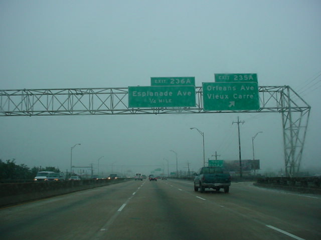
Interstate 10 East at
Exit 236A - Esplanade Ave. I apologize for the poor quality. (Photo taken 12/13/03) |
 |
Interstate 10 East at
Exit 236B - LA 39 - N. Claiborne Ave. (Photo taken 12/13/03) |
 |
Interstate 10 East at
Exit 237 - Elysian Fields Ave. (Photo taken 12/13/03) |
 |
Interstate 10 East at
Exit 239A - Louisa St. South/Almonaster Blvd. East. (Photo taken 12/13/03) |
 |
Interstate 10 East at
Exit 239B - Louisa St. North/Almonaster Blvd. West. (Photo taken 12/13/03) |
 |
Interstate 10 East at
Exit 240A - Downman Rd. (Photo taken 12/13/03) |
 |
Interstate 10 East at
Exit 240B - U.S. 90 East - Chef Hwy. (Photo taken 12/13/03) |
 |
Interstate 10 East at Exit 241 - Morrison Rd. (Photo taken 12/13/03) |
 |
Interstate 10 East at Exit 242 - Crowder Blvd. (Photo taken 12/13/03) |
 |
Interstate 10 East at Exit 244 - Read Blvd. (Photo taken 12/13/03) |

|
Interstate 10 East at
unmarked Exit 245 - Bullard Ave. (Photos taken 12/13/03) |
 |
Interstate 10 East
approaching Exits 246A-B - Interstate 510 South/LA 47 - 3/4 mile. (Photo taken 12/13/03) |
 |
Interstate 10 East
approaching Exits 246A-B - 1/4 mile. (Photo taken 12/13/03) |
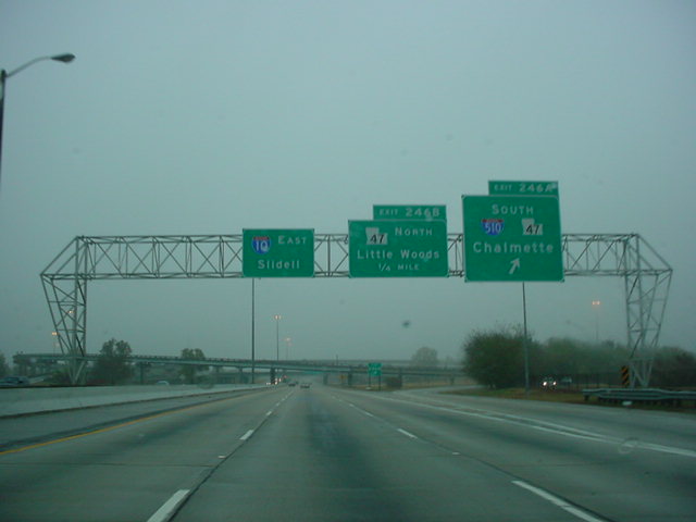 |
Interstate 10 East at
Exit 246A - Interstate 510/LA 47 South - Chalmette. (Photo taken 12/13/03) |
 |
Interstate 10 East at
Exit 246B - LA 47 North - Little Woods. (Photo taken 12/13/03) |
 |
Interstate 10 East at
Exit 248 - Michoud Blvd. There are two other interchanges between this one and the next one pictured, but due to the rain, those pictures did not turn out at all. (Photo taken 12/13/03) |
 |
Interstate 10 East at
Exit 263 - LA 433 - Slidell. (Photo taken 12/13/03) |
 |
Interstate 10 East at
Exit 266 - U.S. 190 - Slidell. Interstate 12 and Interstate 59 are 1 1/2 miles ahead. (Photo taken 12/13/03) |
 |
Interstate 10 East
approaching Exits 267A-B - Interstate 12/Interstate 59 - 1/2 mile. (Photo taken 12/13/03) |
 |
Interstate 10 East at
Exit 267A - Interstate 59 North - Hattiesburg, and Exit 267B - Interstate 12 West - Hammond. This is the final interchange in Louisiana on Interstate 10. (Photo taken 12/13/03) |
Highway Links
Louisiana:
SouthEastRoads.com (Andy Field/Alex Nitzman)
Page created: February 12, 2005
Last updated:
February 12, 2005


