 |
Home Search OKRoads: |
|
|
Home Search OKRoads: |
Interstate 275 Tennessee
Interstate 275 is the original route of Interstate 75 through central Knoxville. Interstate 275 is three miles long and is three lanes wide in each direction between exits, and two lanes in each direction during the interchanges. Speaking of interchanges, there are three cloverleaf interchanges on the interstate between Interstate 40 and Interstate 75/Interstate 640.
|
Highway Information |
|
| Miles | 2.98 |
| Counties Traveled Through |
Knox |
| Cities | Knoxville |
| Major Junctions |
Interstate 40
Interstate 75/ |
| OKRoads Coverage | |
| Miles Driven by OKRoads (Percentage) |
3 (100%) |
| Southern End of Interstate Driven |
Interstate 40 |
| Northern End of Interstate Driven |
Interstate 75/ Interstate 640 |
Pictures
| Interstate 275 North | |
 |
Interstate 275 North approaching Exit 1A - Baxter Avenue eastbound - 1/4 mile. Baxter Avenue is a main arterial between Boyd Street and Central Street. (Photo taken 7/6/05) |
 |
Use Baxter Avenue east to either Lee Street or Wray Street south to the Knoxville National Cemetery. (Photo taken 7/6/05) |
 |
Interstate 275 North at Exit 2A - Baxter Avenue eastbound. (Photo taken 7/6/05) |
 |
Interstate 275 North at Exit 1B - Baxter Avenue westbound. The next cloverleaf interchange is just one-quarter mile ahead, serving Woodland and Oldham avenues. (Photo taken 7/6/05) |
 |
Interstate 275 North assurance shield just before the Exit 1C-D interchange. After driving this interstate, it is easy to see why Interstate 75 was rerouted along Interstate 640 to the west, with its narrow right-of-way, tight cloverleaf interchanges, and the S-curve ahead. (Photo taken 7/6/05) |
 |
Interstate 275 North at Exit 1C - Woodland Avenue. Technically, this exit serves Oldham Avenue eastbound, but the street name changes at the Norfolk Southern railroad track just after merging onto the arterial. Woodland Avenue continues eastbound to Broadway (U.S. 441). (Photo taken 7/6/05) |
 |
Interstate 275 North at Exit 1D - Oldham Avenue westbound. The arterial heads southwest and then changes names yet again within two miles, this time to the north-south Toms Street. Interstate 640 is two miles ahead. Interstate 275 goes through a S-curve between Oldham Avenue and the next exit, Heiskell Avenue. (Photo taken 7/6/05) |
 |
Interstate 275 North approaching Exits 2A-B - Central Street/Heiskell Avenue - 1/2 mile. Central Street runs north-south just to the east of the Norfolk Southern railroad tracks. There, Heiskell Avenue concludes. (Photo taken 7/6/05) |
 |
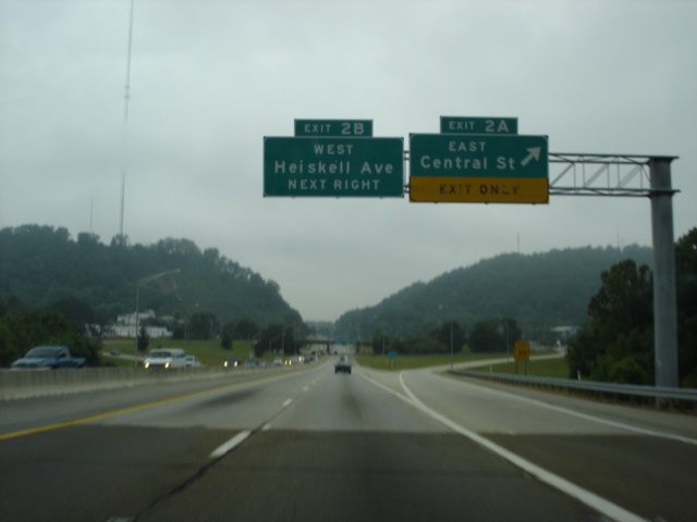
Interstate 275 North approaching Exit 2A - East Heiskell Avenue - 1/4 mile, and Exit 2B - Heiskell Avenue westbound - 1/2 mile. The Exit 2A guide sign says East Central Street, even though it runs north-south. (Photo taken 7/6/05) |
 |
Interstate 275 North at Exit 2A - East Heiskell Avenue to Central Street. Central Street runs north-south parallel to Interstate 275 for the interstate's whole length, then continues parallel to Interstate 75 to Exit 112. (Photo taken 7/6/05) |
 |
Interstate 275 North at Exit 2B - Heiskell Avenue westbound. These reflective overheads replaced old, damaged overheads that were present in 2003. (Photo taken 7/6/05) |
 |
Interstate 275 North prepares to conclude as Exit 3 for U.S. 25W and Interstate 640 quickly approaches. On all guide signs for Exit 3, U.S. 25W is given precedence. The federal highway enters the interchange from the northwest and merges onto Interstate 640 East, where it will duplex with Interstate 640 until the interstate ends. (Photo taken 7/6/05) |
 |
Interstate 275 North at Exit 3 - U.S. 25W/Interstate 640 - Clinton/Asheville. There is no mention of Interstate 75 South here because there is no direct connection from Interstate 275 North to Interstate 75 South/Interstate 640 West. However, one can use U.S. 25W North for a short stint and a loop ramp connects motorists to Interstate 75 South and Interstate 640 West. (Photo taken 7/6/05) |
 |
Clinton, population 9,409, is 14 miles to the northwest. The city is located on the Clinch River at the intersection of U.S. 25W and Tennessee 61. (Photo taken 7/6/05) |
 |
Interstate 275 North comes to an end as we pass underneath Interstate 640. Mile marker 3 is located here, even though the interstate ended 0.02 miles prior this point. But who's counting? No end sign is present at either terminus. (Photo taken 7/6/05) |
| Interstate 275 South | |
 |
After the departure of Interstate 75 from the mainline onto Interstate 640 West, Interstate 275 South begins. The first exit is Exit 3, signed with a 20 mph advisory speed due to the tight loop ramp to Interstate 640 East. The flyover in the foreground carries northbound Interstate 75 traffic away from Interstate 640. (Photo taken 7/6/05) |
 |
Interstate 275 South at Exit 3 - Interstate 640 East. Asheville, North Carolina, is on the opposite side of the Great Smoky Mountains, 115 miles to the east. (Photo taken 7/6/05) |
 |
Interstate 275 South approaching Exits 2A-B - Heiskell Avenue/Central Street - 1/2 mile. This is the first of three consecutive cloverleaf interchanges on the interstate. (Photo taken 7/6/05) |
 |
Interstate 275 South approaching Exit 2B - Heiskell Avenue - 1/4 mile. Unlike northbound, cardinal directions are not used for this exit on southbound. (Photo taken 7/6/05) |
 |
Interstate 275 South at Exit 2B - Heiskell Avenue. The next exit is Exit 2A, Central Avenue. (Photo taken 7/6/05) |
 |
Interstate 275 South at Exit 2A - Central Avenue. The exit directly serves Heiskell Avenue eastbound, which will lead to Central Avenue within one-quarter of a mile. (Photo taken 7/6/05) |
 |
Interstate 275 South as it enters the S-curve near mile marker 2. Looking at the surroundings, it is hard to believe that we are in a city of over 170,000 people. (Photo taken 7/6/05) |
 |
Interstate 275 South approaching Exits 1C-D - Oldham Avenue/Woodland Avenue - 1/2 mile. For some reason, Woodland Avenue has been greened out from this sign. The gantry also supports the first warning of the Interstate 40 interchange in 1 1/4 miles. (Photo taken 7/6/05) |
 |
Use Exit 1A (Baxter Avenue eastbound) to Lee Street to the Knoxville National Cemetery. (Photo taken 7/6/05) |
 |
Interstate 275 South as it enters the final leg of the S-curve north of downtown Knoxville. Exit 1D (Oldham Avenue west) is 1/4 mile ahead. (Photo taken 7/6/05) |
 |
Interstate 275 South at Exit 1D - Oldham Avenue westbound. (Photo taken 7/6/05) |
 |
Interstate 275 South at Exit 1C - Woodland Avenue eastbound. Just one-quarter mile separates this cloverleaf from the next interchange, also a cloverleaf. (Photo taken 7/6/05) |
 |
Interstate 275 South at Exit 1B - Baxter Avenue westbound. (Photo taken 7/6/05) |
 |
Interstate 275 South at Exit 1A - Baxter Avenue eastbound. Travelers wanting to visit downtown Knoxville are advised to use U.S. 441 south, which is accessible from the ramp connecting Interstate 275 South to Interstate 40 East. (Photo taken 7/6/05) |
 |
The right lane becomes an exit only lane to Interstate 40 East and U.S. 441 South as the Knoxville skyline comes into view. (Photo taken 7/6/05) |
 |
Interstate 275 South at Interstate 40 East/U.S. 441 South. The mainline defaults to Interstate 40 westbound because it was once the continuation of Interstate 75 south from here. Now that Interstate 75 has been rerouted around downtown Knoxville, the sign says Interstate 40 West TO Interstate 75 South. (Photo taken 7/6/05) |
 |
For those wanting to go downtown, this is where you need to exit. The off-ramp here ends at U.S. 441 near City Hall. A connection to Tennessee Secondary 62 is also provided from the ramp to U.S. 441 South. (Photo taken 7/6/05) |
 |
A view of the Knoxville skyline from the ramp connecting Interstate 275 south to Interstate 40 east. The golden ball on the right is the Sun Sphere, built for the 1982 World's Fair held in Knoxville. The structure is now located next to the Knoxville Convention Center, but has been closed to the public since 1998. (Photo taken 7/6/05) |
Selected Links
Interstate 275 Tennessee @ SouthEastRoads.com (Andy Field/Alex Nitzman)
Page created: November 03, 2005
Last updated:
November 03, 2005