|
Home Search OKRoads: |
|
|
Home Search OKRoads: |
Interstate 410 Texas
Interstate 410 is the beltway around San Antonio, Texas. The highway is duplexed with Interstate 35 for about three miles at the beltway's northeast corner.
|
Highway Information |
|
| Miles | 53.49 (includes duplex with Interstate 35) |
| Counties Traveled Through |
Bexar |
| Cities | San Antonio |
| Major Junctions |
Interstate 35 (Exit 27, Exit 31, Exit 53) U.S. 90 Interstate 10 U.S. 281 Interstate 37 |
| OKRoads Coverage | |
| Miles Driven by OKRoads (Percentage) |
53 (100%) |
| Western End of Interstate Driven |
Interstate 35 |
| Eastern End of Interstate Driven |
Interstate 35 |
Pictures
| Outer Loop | |
 |
Interstate 410 and Texas 16 North at Exit 1 - Frontage Road. This particular frontage road is short as it is bounded by railroad tracks within one mile on each side of the exit. (Photo taken 3/17/05) |
 |
Interstate 410 and Texas 16 North approaching Exit 2 - Farm to Market Road 2536 - 3/4 mile. FM 2536 connects Loop 1604 to Loop 13 in southwest San Antonio. (Photo taken 3/17/05) |
 |
Interstate 410 and Texas 16 North at Exit 2 - Farm to Market Road 2536 - Old Pearsall Road. (Photo taken 3/17/05) |
 |
Interstate 410 and Texas 16 North approaching Exit 3 - Ray Ellison Drive/Medina Base Road - 1 mile. (Photo taken 3/17/05) |
 |
Interstate 410 and Texas 16 North at Exit 3 - Ray Ellison Drive/Medina Base Road. Use either road to go between Lackland Air Force Base and the Lackland Training Annex. (Photo taken 3/17/05) |
 |
Interstate 410 and Texas 16 North approaching Exit 4 - Valley Hi Drive/Lackland Air Force Base - 1/2 mile, and Exit 6 - U.S. 90 - 1 mile. (Photo taken 3/17/05) |
 |
Interstate 410 and Texas 16 North at Exit 4 - Valley Hi Drive/Lackland Air Force Base. The exit to U.S. 90 is 1/4 mile ahead. After seeing a 70 mph speed limit since the eastern Interstate 10 junction (Exit 33), the speed limit falls to 60 at this interchange. (Photo taken 3/17/05) |
 |
U.S. 90 is known as the Cleto Rodriguez Freeway through west San Antonio. I would think this freeway would be named after the man who was the first Mexican American to win a Congressional Medal of Honor, not the Christian comedian of today's fame who happens to be from San Antonio. (Photo taken 3/17/05) |
 |
Interstate 410 and Texas 16 North at Exit 6 - U.S. 90 - San Antonio/Del Rio. The interchange is a cloverleaf with all the connections being made via the frontage roads. (Photo taken 3/17/05) |
 |
Interstate 410 and Texas 16 northbound frontage road at U.S. 90 East. Downtown San Antonio is nine miles to the east. (Photo taken 3/17/05) |
 |
Interstate 410 and Texas 16 northbound frontage road at U.S. 90 West - Del Rio. A 141 mile drive separates Interstate 410 from Del Rio. (Photo taken 3/17/05) |
 |
Interstate 410 and Texas 16 North approaching Exit 7 - Marbach Road - 3/4 mile. (Photo taken 3/17/05) |
 |
Interstate 410 and Texas 16 North approaching Exit 7 - 1/4 mile. Three lanes of travel continue on Interstate 410 North to Spur 345. (Photo taken 3/17/05) |
 |
Interstate 410 and Texas 16 North at Exit 7 - Marbach Road. The next exit is for the Stotzer Freeway (Texas 151), 1 1/4 miles. (Photo taken 3/17/05) |
 |
The Stotzer Freeway connects Loop 1604 to U.S. 90 in northwest San Antonio. Sea World San Antonio is located near Texas 151's western terminus. (Photo taken 3/17/05) |
 |
Use Exit 9 to access Military Drive, a major surface arterial connecting northwest and southeast San Antonio. Much of the arterial is also part of Loop 13. (Photo taken 3/17/05) |
 |
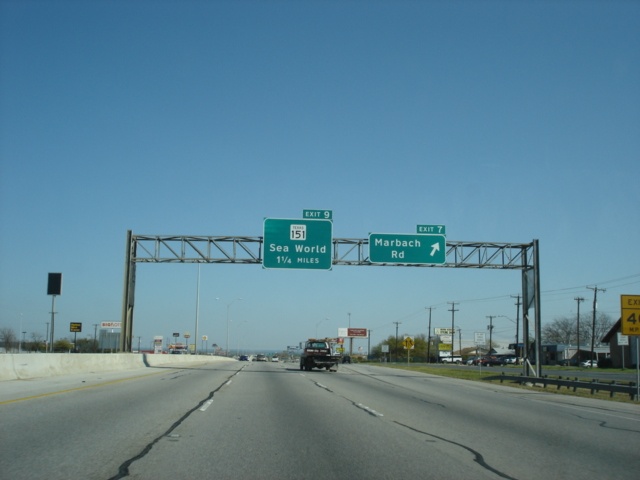
Interstate 410 and Texas 16 North approaching Exit 9 - Texas 151 - 1/4 mile. (Photo taken 3/17/05) |
 |
Interstate 410 and Texas 16 North at Exit 9 - Texas 151 - Sea World. (Photo taken 3/17/05) |
 |
Interstate 410 and Texas 16 North approaching Exit 10 - Farm to Market Road 3487/Culebra Road - 3/4 mile, and Exit 11 - Ingram Road - 1 mile. (Photo taken 3/17/05) |
 |
St. Mary's University, which is the oldest and largest Catholic university in Texas and the Southwest according to their website, is located four miles to the east near the corner of Culebra Road and NW 36th Street. (Photo taken 3/17/05) |
 |
Interstate 410 and Texas 16 North approaching Exit 10 - Farm to Market Road 3487/Culebra Road - 1/4 mile. (Photo taken 3/17/05) |
 |
Interstate 410 and Texas 16 North at Exit 10 - Farm to Market Road 3487/Culebra Road. The next exit is Exit 11, Ingram Road, 1/4 mile. (Photo taken 3/17/05) |
 |
Use Exit 11 to access Ingram Park Mall. The mall is located just off of Loop 410 at Ingram Road. (Photo taken 3/17/05) |
 |
Interstate 410 and Texas 16 North at Exit 11 - Ingram Road. The departure of Texas 16 from Interstate 410 is two miles ahead. (Photo taken 3/17/05) |
 |
Interstate 410 North becomes Interstate 410 East as the departure of Texas 16 draws within one mile of us. (Photo taken 3/17/05) |
 |
Spur 421 continues the southeasterly track of Texas 16 and connects Interstate 410 to Interstate 10. A Park & Ride facility is also located near this exit. (Photo taken 3/17/05) |
 |
Interstate 410 East and Texas 16 North approaching Exit 13A - Texas 16 North/Spur 421 East - 1/4 mile. (Photo taken 3/17/05) |
 |
Interstate 410 East and Texas 16 North at Exit 13A - Texas 16 North/Spur 421 East - Leon Valley/San Antonio/Bandera Road/Evers Road. Texas 16 will enter Bandera in 38 miles. (Photo taken 3/17/05) |
 |
Interstate 410 East approaching Exit 14 - Callaghan Road/Babcock Road - 3/4 mile. (Photo taken 3/17/05) |
 |
Interstate 410 East at Exit 14 - Callaghan Road/Babcock Road. The next exit is Exit 15, Loop 345, one mile ahead. (Photo taken 3/17/05) |
 |
Interstate 410 East approaching Exit 16B - Interstate 10 West/U.S. 87 North - 1 mile, and Exit 16A - Interstate 10 East/U.S. 87 South - 1 1/4 miles. The approaching interchange is in the final stage of a massive reconstruction project. (Photo taken 3/17/05) |
 |
Interstate 410 East approaching Exit 15 - Loop 345 - 1/4 mile. Loop 345, also known as Fredericksburg Road, is the former route of U.S. 87 in northwest San Antonio. (Photo taken 3/17/05) |
 |
Interstate 410 East at Exit 15 - Loop 345 - Fredericksburg Road to Balcones Heights. Interstate 10 and U.S. 87 are less than one mile away. (Photo taken 3/17/05) |
 |
The right lane becomes the exit ramp to Interstate 10 West and U.S. 87 North, while the second lane from the outside becomes exit only to Interstate 10 East and U.S. 87 South. When construction is complete, it appears to us that both ramps will be combined onto one ramp (the current Interstate 10 West ramp) and will then split from that single ramp. (Photo taken 3/17/05) |
 |
Interstate 410 East at Exit 16B - Interstate 10 West/U.S. 87 North - El Paso/San Angelo. Both cities are over 100 miles away from here, with El Paso being about 540 miles to the west of this point. (Photo taken 3/17/05) |
 |
The next three photos show the Exit 16B ramp from Interstate 410 East to Interstate 10 West and U.S. 87 North. With extra supports in place, it looks like that eventually a ramp to Interstate 10 East and U.S. 87 South will also depart from this ramp once construction is complete. (Photo taken 3/17/05) |
 |
This view looks at what will eventually be the split of the off ramp to westbound and eastbound Interstate 10. (and again, northbound and southbound U.S. 87). (Photo taken 3/17/05) |
 |
A 35 mph advisory speed is in place on the ramp to Interstate 10 West and U.S. 87 North. It appears to us that this may only be temporary until all of the ramps are fully completed. (Photo taken 3/17/05) |
 |
Interstate 410 East approaching Exit 17B - Vance Jackson Road - 1/2 mile, and Exit 18 - Jackson-Keller Road/West Avenue - 3/4 mile. Exit 18 also serves Honeysuckle Lane, but it appears the sign contractors forgot to include that on this particular sign, even though there looks like there is room for it to be added in the future. (Photo taken 3/17/05) |
 |
Now just one-quarter mile from Vance Jackson Road, Honeysuckle Lane makes its first appearance on an Exit 18 guide sign. The speed limit remains 60 mph throughout the northern half of the loop. (Photo taken 3/17/05) |
 |
Interstate 410 East at Exit 17B - Vance Jackson Road. The ramp for Exit 18 will depart in one-quarter mile. (Photo taken 3/17/05) |
 |
Interstate 410 East at Exit 18 - Jackson-Keller Road/West Avenue/Honeysuckle Lane. (Photo taken 3/17/05) |
 |
Interstate 410 East approaching Exit 19 - Farm to Market roads 1535 and 2696 - 1 mile. FM 1535 is known as Military Highway through northwest San Antonio and eventually reaches the Camp Bullis military reservation. (Photo taken 3/17/05) |
 |
Interstate 410 East approaching Exit 19 - 1/4 mile, and Exit 21A - U.S. 281 to Interstate 37 - 2 miles. This is the only time that Interstate 37 is mentioned for this interchange. (Photo taken 3/17/05) |
 |
Interstate 410 East at Exit 19 - Farm to Market Road 1535/Military Highway and Farm to Market Road 2696/Blanco Road. Both highways travel through Castle Hills, a suburb of San Antonio. (Photo taken 3/17/05) |
 |
Interstate 410 East approaching Exit 20 - U.S. 281 North - 1/2 mile. (Photo taken 3/17/05) |
 |
Interstate 410 East approaching Exit 20 - San Pedro Avenue/McCullough Avenue - Next Right. For some reason, U.S. 281 is left off of this particular sign. (Photo taken 3/17/05) |
 |
Signage in this particular area was a bit confusing, plus a couple of our pictures in this area did not turn out well. The unsigned exit to Jones-Maltsberger Road is one mile ahead. It may be part of Exit 21A, but we don't know for sure. (Photo taken 3/17/05) |
 |
Interstate 410 East approaching Exit 21B - U.S. 281 South - 1/4 mile. Much has been written about the Interstate 410/U.S. 281 non-interchange elsewhere so I'll only say here that the connection between these freeways occurs along surface arterials. (Photo taken 3/17/05) |
 |
Interstate 410 East at Exit 21B - U.S. 281 South - Airport Boulevard/Wetmore Road. Use this exit to get to the San Antonio International Airport located at the northeast corner of Interstate 410 and U.S. 281. (Photo taken 3/17/05) |
 |
Interstate 410 East approaching Exit 22 - Broadway - 3/4 mile. The overpasses ahead carry U.S. 281 over the beltway. (Photo taken 3/17/05) |
 |
Interstate 410 East at Exit 22 - Broadway. (Photo taken 3/17/05) |

|
Interstate 410 East at Exit 23 - Nacogdoches Road. (Top photo taken 10/18/03, bottom photo taken 3/17/05) |

|
Interstate 410 East at Exit 24 - Harry Wurzbach Road/Fort Sam Houston. (Top photo taken 10/18/03, bottom photo taken 3/17/05) |
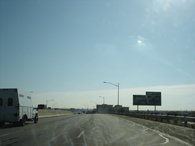 |
Interstate 410 East approaching Exit 25A - Starcrest Drive - 3/4 mile. (Photo taken 3/17/05) |
 |
Interstate 410 East approaching Exit 25A - Starcrest Drive - Next Right. (Photo taken 3/17/05) |

|
Interstate 410 East at Exit 25A - Starcrest Drive. Interstate 35 is 1 3/4 miles ahead. (Top photo taken 10/18/03, bottom photo taken 3/17/05) |

|
Interstate 410 East at Exit 25B - Farm to Market Road 2252 - Perrin-Beltel Rd. (Top photo taken 10/18/03, bottom photo taken 3/17/05) |
 |
Interstate 410 East approaching Exit 26A - Loop 368 South - 1/2 mile. Loop 368 is the original route of U.S. 81 through northeast San Antonio. (Photo taken 3/17/05) |

|
Interstate 410 East at Exit 26A - Loop 368 South - Alamo Heights. (Top photo taken 10/18/03, bottom photo taken 3/17/05) |
 |
Interstate 410 East approaching Exit 26B - Interchange Parkway/Perrin Creek Drive - Next Right. The exit consists of a slip ramp to the frontage road. (Photo taken 3/17/05) |

|
Interstate 410 East at Exit 26B - Interchange Pkwy./Perrin Creek Dr. Interstate 410 departs via a one-lane ramp just ahead. (Top photo taken 10/18/03, bottom photo taken 3/17/05) |

|
Interstate 410 East at Exit 26 - Interstate 35/Interstate 410 South - San Antonio. The odd thing is that the Interstate 410 exit from Interstate 410 is given a number, but the exit to Interstate 35 North is not. The exit number is only on the gore sign. (Top photo taken 10/18/03, bottom photo taken 3/17/05) |
 |
The aforementioned gore point sign at Exit 26. This is the ramp that mainline Interstate 410 traffic takes as the freeway changes direction from east to south. (Photo taken 3/17/05) |
 |
Interstate 35 and Interstate 410 South approaching Exit 165 - Farm to Market Road 1976/Walzem Road. (Photo taken 3/17/05) |

|
Interstate 35/Interstate 410 South at Exit 165 - FM 1976 - Walzem Road. (Top photo taken 10/18/03, bottom photo taken 3/17/05) |

|
Interstate 35/Interstate 410 South approaching Exit 164B - Eisenhauer Road - 1/4 mile, and Exit 163 - Interstate 410 South - 2 miles. (Top photo taken 10/18/03, bottom photo taken 3/17/05) |

|
Interstate 35/Interstate 410 South at Exit 164B - Eisenhauer Road. (Top photo taken 10/18/03, bottom photo taken 3/17/05) |
 |
Interstate 35 and Interstate 410 South approaching Exit 164A - Rittiman Road - 1/4 mile. Construction to change the metal median barrier into a concrete one was ongoing during our return trip to San Antonio in March 2005. (Photo taken 3/17/05) |

|
Interstate 35/Interstate 410 South at Exit 164A - Rittiman Road. (Top photo taken 10/18/03, bottom photo taken 3/17/05) |

|
Interstate 35/Interstate 410 South approaching Exit 162 - Brooke Army Medical Center/Binz-Engleman Road - 1 mile. (Top photo taken 10/18/03, bottom photo taken 3/17/05) |
 |
Interstate 35/Interstate 410 South approaching Exit 163 - 1/4 mile. (Photo taken 10/18/03) |
 |
Interstate 35 and Interstate 410 South approaching the Interstate 35-only ramp to Farm to Market Road 78 and George Beach Avenue. Both are accessible via the frontage roads. For direct access to FM 78, use Interstate 410 South to Exit 31A. (Photo taken 3/17/05) |

|
Interstate 35/Interstate 410 South at Exit 163 - Interstate 410 South. (Top photo taken 10/18/03, bottom photo taken 3/17/05) |

|
Interstate 410 South at Exit 30 - Binz-Engleman Road. (Top photo taken 10/18/03, bottom photo taken 3/17/05) |
 |
Interstate 410 South approaching Exit 31A - Farm to Market Road 78 - 1/4 mile. FM 78 connects Interstate 410 to Kirby, Randolph Air Force Base, Marion, and Seguin. (Photo taken 3/17/05) |

|
Interstate 410 South at Exit 31A - FM 78 - Kirby. (Top photo taken 10/18/03, bottom photo taken 3/17/05) |

|
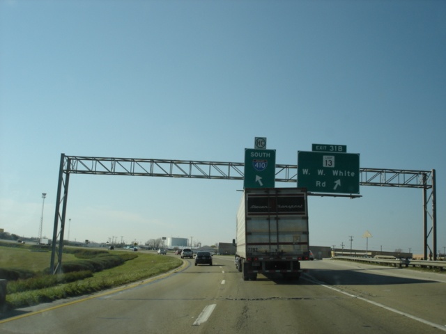
Interstate 410 South at Exit 31B - TX Loop 13 - W.W. White Rd. This exit is located inside the Interstate 410 North connection to Interstate 35 South, which explains the wide median and the curvature of the roadway. (Top photo taken 10/18/03, bottom photo taken 3/17/05) |
 |
Interstate 410 South approaching Exit 32 - Dietrich Road - 1/2 mile, and Exit 33 - Interstate 10/U.S. 90 - 3/4 mile. (Photo taken 3/17/05) |
|
|
Interstate 410 South at Exit 32 - Dietrich Rd. Interstate 10 is 1/4 mile ahead. (Top photo taken 10/18/03, bottom photo taken 3/17/05) |

|
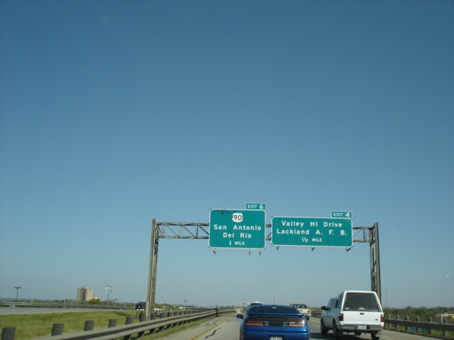
Interstate 410 South at Exit 33 - Interstate 10/U.S. 90 - San Antonio/Houston. (Top photo taken 10/18/03, bottom photo taken 3/17/05) |

|
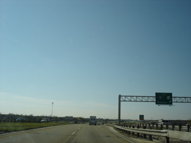
Interstate 410 South c/d lane at Interstate 10/U.S. 90 West - San Antonio. (Top photo taken 10/18/03, bottom photo taken 3/17/05) |

|
Interstate 410 South c/d lane at Interstate 10/U.S. 90 East - Houston. (Top photo taken 10/18/03, bottom photo taken 3/17/05) |
 |
After crossing over Interstate 10 and U.S. 90, the speed limit increases to 70 as Exit 34 for Farm to Market Road 1346 approaches in 1/4 mile. (Photo taken 3/17/05) |
 |
Interstate 410 South at Exit 34 - Farm to Market Road 1346/East Houston Street. FM 1346 meets its western terminus within one mile to the west at Loop 13. (Photo taken 3/17/05) |
 |
Interstate 410 South approaching Exit 35 - U.S. 87 - 1 mile. (Photo taken 3/17/05) |
 |
Interstate 410 South approaching Exit 35 - U.S. 87 - 1/2 mile. The federal highway enters San Antonio from the southeast and meets Interstate 10 east of downtown. From there Interstate 10 and U.S. 87 are duplexed for 54 miles. (Photo taken 3/17/05) |
 |
Interstate 410 South at Exit 35 - U.S. 87/Rigsby Avenue. Victoria is 105 miles to the southeast and is home for 60,603 people. (Photo taken 3/17/05) |
 |
Interstate 410 South approaching Exit 37 - Southcross Boulevard - 1 mile. (Photo taken 3/17/05) |
 |
Southcross Boulevard is the name of this arterial west of the interstate. The street name changes to Sulphur Springs Road after passing Interstate 410. (Photo taken 3/17/05) |
 |
Interstate 410 South at Exit 37 - Southcross Boulevard/Sulphur Springs Road. The next exit is Exit 39, Spur 117, 1 1/4 miles. (Photo taken 3/17/05) |
 |
Interstate 410 South at Exit 39 - Spur 117/W.W. White Road. Spur 117 is a short route connecting Interstate 410 to the southeast corner of Loop 13. (Photo taken 3/17/05) |
 |
Interstate 410 South approaching Exit 41 - Interstate 37/U.S. 281 North - 1 mile. The stack interchange is the southeast corner of Interstate 410. (Photo taken 3/17/05) |
 |
Interstate 37 and U.S. 281 are known as the Lucian Adams Freeway through southern San Antonio. Mr. Adams received a Congressional Medal of Honor during World War II and is a native of Port Arthur, Texas. (Photo taken 3/17/05) |
 |
Interstate 410 East approaching Exit 41 - Interstate 37/U.S. 281 - 1/2 mile. (Photo taken 3/17/05) |
 |
Use Interstate 37 South to Exit 132 and the beginning of U.S. 181. Floresville is a 21 mile drive from Interstate 410. (Photo taken 3/17/05) |
 |
Interstate 410 South at Exit 41 - Interstate 37/U.S. 281 North - San Antonio/Corpus Christi. A 133 mile drive separates Interstate 410 from the southern terminus of Interstate 37 in Corpus Christi. The southern terminus of U.S. 181 is located at the same location as that of Interstate 37. (Photo taken 3/17/05) |
 |
A view of the Interstate 410/Interstate 37 stack interchange. Interstate 410 and U.S. 281 share a three mile duplex. (Photo taken 3/17/05) |
 |
Interstate 410 West and U.S. 281 South approaching Exit 42 - Spur 122 - 1/4 mile. (Photo taken 3/17/05) |
 |
Interstate 410 West and U.S. 281 South at Exit 42 - Spur 122/S. Presa Street/Southton Road. Spur 122 was once part of U.S. 181. (Photo taken 3/17/05) |
 |
Interstate 410 West and U.S. 281 South approaching Exit 44 - U.S. 281 South/Spur 536 - 1/2 mile. (Photo taken 3/17/05) |
 |
Espada Road is accessible via the westbound frontage road near Exit 44. (Photo taken 3/17/05) |
 |
Interstate 410 West and U.S. 281 South approaching Exit 44 - U.S. 281 South/Spur 536 - 1/4 mile. (Photo taken 3/17/05) |
 |
Interstate 410 West and U.S. 281 South at Exit 44 - U.S. 281 South/Spur 536 North - Roosevelt Avenue. Pleasanton is located 24 miles to the south. Spur 536 is the former route of U.S. 281 in south San Antonio. (Photo taken 3/17/05) |
 |
Interstate 410 West approaching Exit 46 - Moursund Boulevard - 1/4 mile. (Photo taken 3/17/05) |
 |
Interstate 410 West at Exit 46 - Moursund Boulevard. (Photo taken 3/17/05) |
 |
Interstate 410 West approaching Exit 48 - Zarzamora Street - 3/4 mile. A new Toyota plant is being built near this interchange. (Photo taken 3/17/05) |
 |
Interstate 410 West at Exit 48 - Zarzamora Street. The next exit is Exit 49, Texas 16 South and Spur 422 - 1 mile. (Photo taken 3/17/05) |
 |
Interstate 410 West at Exit 49 - Texas 16 South/Spur 422/Palo Alto Road. Spur 422 connects Interstate 410 and Texas 16 to Interstate 35. Poteet is 23 miles to the south on Texas 16. For the next 17 miles, Interstate 410 and Texas 16 are duplexed. (Photo taken 3/17/05) |
 |
Interstate 410 West and Texas 16 North assurance shields just west of Exit 49. The next exit is Exit 51 for Farm to Market Road 2790. (Photo taken 3/17/05) |
 |
Interstate 410 West and Texas 16 North approaching Exit 51 - Farm to Market Road 2790 - 3/4 mile. (Photo taken 3/17/05) |
 |
Farm to Market Road 2790 is also known as Somerset Road. The namesake town is located 8 miles to the south. (Photo taken 3/17/05) |
 |
Interstate 410 West and Texas 16 North at Exit 51 - Farm to Market Road 2790 - Somerset. Interstate 35 is one mile ahead. (Photo taken 3/17/05) |
 |
Interstate 410 West and Texas 16 North approaching Exit 53 - Interstate 35 - 1/2 mile. The interchange is a cloverleaf, with all movements made from collector/distributor lanes. (Photo taken 3/17/05) |
 |
Interstate 410 West and Texas 16 North at Exit 53 - Interstate 35 - San Antonio/Laredo. The border city is less than 150 miles to the south. (Photo taken 3/17/05) |
Highway Links
LoneStarRoads.com (Andy Field/Alex Nitzman)
Interstate-Guide.com (Andy Field/Alex Nitzman)
Interstate 410 @ Texas HighwayMan (Brian Purcell)
Page created: February 12, 2005
Last updated:
June 25, 2005