 |
Home Search OKRoads: |
|
|
Home Search OKRoads: |
Interstate 74 Illinois
Westbound - Indiana State Line to
Interstate 57
|
Highway Information |
|
| Miles | 220.34 |
| Counties Traveled Through |
Rock Island, Henry, Knox, Peoria, Tazewell, Woodford, McLean, De Witt, Piatt, Champaign, Vermilion |
| Cities |
Moline, Galesburg, Peoria, Bloomington, Champaign, Urbana, Danville |
| Major Junctions | Interstate 280 (Exit 5)
Interstate 80 Interstate 474 Interstate 155 Interstate 55 Interstate 57 |
| OKRoads Coverage | |
| Miles Driven by OKRoads (Percentage) |
93 (42%) |
| Western End of Interstate Driven |
Interstate 55 |
| Eastern End of Interstate Driven |
Indiana State Line |
Pictures
Westbound:
Indiana State Line to Interstate 57
Interstate 57 to Interstate 55
| Interstate 74 West | |
 |
Interstate 74 West at the Illinois state line. After spending 171.54 miles in Indiana, the interstate travels 220.34 miles in the Land of Lincoln. (Photo taken 7/11/05) |
 |
The people of Illinois officially welcome us to their state. Illinois has a population of over 12 million people, much of which live around the Chicago and St. Louis metropolitan areas. (Photo taken 7/11/05) |
 |
Interstate 74 West at Exit 220 - Lynch Road. This off-ramp is located about one-quarter mile west of the state line. Lynch Road is also the first exit for the city of Danville, population 33,904. (Photo taken 7/11/05) |
 |
Interstate 74 West approaching Exit 216 - Bowman Avenue - 1 mile. Bowman Avenue is a north-south arterial through central Danville. (Photo taken 7/11/05) |
 |
The speed limit falls to 55 as we approach Exit 216. This is one of the great low speed limit mysteries. The speed limit on Interstate 74 through Champaign (pop. 67,518) is 65, yet a city half its size has a lower speed limit. At the end of the off-ramp, take a left on Texas Avenue to Perrysville Road. (Photo taken 7/11/05) |
 |
Interstate 74 West at Exit 216 - Bowman Avenue/Perrysville Road. (Photo taken 7/11/05) |
 |
The next two exits serve the village of Tilton, a southern suburb of Danville. Tilton had a population of 2,976 according to the 2000 census. (Photo taken 7/11/05) |
 |
Interstate 74 West approaching Exits 215A-B - U.S. 150/Illinois 1 - 1 mile. Illinois 1 travels north-south through Danville. U.S. 150 comes in from the south and then heads west along the path of U.S. 136. U.S. 136, which closely parallels Interstate 74 between Danville and Indianapolis, heads to the north on Illinois 1. U.S. 150 will closely parallel Interstate 74 from Danville to Rock Island. (Photo taken 7/11/05) |
 |
Interstate 74 West approaching Exits 215A-B - U.S. 150/Illinois 1 - 1/2 mile. Gilbert Street carries the highways in Danville; south of the interstate, the arterial is Georgetown Road through Tilton. (Photo taken 7/11/05) |
 |
Use Exit 215A (U.S. 150 East and Illinois 1 South) for five miles to the village of Westville. (Photo taken 7/11/05) |
 |
Interstate 74 West at Exits 215A-B - U.S. 150/Illinois 1 - Georgetown Road/Gilbert Street. This ramp provides access to a collector/distributor setup, where there is access to both directions of U.S. 150 and Illinois 1. (Photo taken 7/11/05) |
 |
Interstate 74 West c/d lane at Exit 215B - U.S. 150 West/Illinois 1 North - Gilbert Street. (Photo taken 7/11/05) |
 |
Interstate 74 West c/d lane at Exit 215A - U.S. 150 East/Illinois 1 South - Georgetown Road. The next interchange is Exit 214, G Street, one-half mile. (Photo taken 7/11/05) |
 |
Interstate 74 West at Exit 214 - G Street. (Photo taken 7/11/05) |
 |
Interstate 74 West approaching Exit 210 - U.S. 150 - 1 mile. At the ahead interchange, U.S. 150 moves to the south side of Interstate 74. The highways will switch sides again after Exit 159 in De Witt County. (Photo taken 7/11/05) |
 |
Use Exit 210 to the Kickapoo State Park and the Middle Fork State Fish & Wildlife Area. The Kennekuk Cove County Park is located just east of the wildlife area. (Photo taken 7/11/05) |
 |
Interstate 74 West approaching Exit 210 - U.S. 150 - 1/2 mile. The Vermilion County fairgrounds are also located near this exit. (Photo taken 7/11/05) |
 |
Interstate 74 West at Exit 210 - U.S. 150 - Martin Luther King Drive. King Drive is the major east-west arterial through Danville. (Photo taken 7/11/05) |
 |
Interstate 74 West approaching the Vermilion County rest area - 1 mile. (Photo taken 7/11/05) |
 |
Interstate 74 West approaching the Vermilion County rest area - 1/4 mile. Tourist information is available. (Photo taken 7/11/05) |
 |
Interstate 74 West at the Vermilion County rest area and tourist information center. (Photo taken 7/11/05) |
 |
Interstate 74 West approaching Exit 206 - Oakwood/Potomac - 1 mile. Oakwood is located on U.S. 150 to the south, and Potomac is 15 miles to the north along U.S. 136. (Photo taken 7/11/05) |
 |
Interstate 74 West approaching Exit 206 - Oakwood/Potomac - 1/2 mile. (Photo taken 7/11/05) |
 |
Interstate 74 West at Exit 206 - Oakwood/Potomac. (Photo taken 7/11/05) |
 |
Interstate 74 West approaching Exit 200 - Illinois 49 - 1 mile. The state highway travels 137 miles from Willow Hill to U.S. 45 and U.S. 52 near Ashkum. (Photo taken 7/11/05) |
 |
Interstate 74 West approaching Exit 200 - Illinois 49 - 1/2 mile. Illinois 49 meets U.S. 150 about 0.7 mile south of the interstate, and travels west with the federal highway for a three-mile duplex. (Photo taken 7/11/05) |
 |
Interstate 74 West at Exit 200 - Illinois 49 - Fithian/Rankin. Fithian is located on U.S. 150 just east of Illinois 49, and Rankin is 25 miles to the north. (Photo taken 7/11/05) |
 |
Interstate 74 West approaching Exit 197 - Illinois 49 South - 1 mile. The exit does not directly serve the state highway, but the road the exit accesses, Champaign County 22, becomes Illinois 49 once it passes U.S. 150 in Ogden. (Photo taken 7/11/05) |
 |
Head south on Illinois 49 for six miles to the village of Homer, population 1,200. (Photo taken 7/11/05) |
 |
Interstate 74 West approaching Exit 197 - Illinois 49 South - 1/2 mile. Royal is located on Champaign County 20, which is five miles to the north. (Photo taken 7/11/05) |
 |
Interstate 74 West at Exit 197 - Illinois 49 South/Champaign County 20 - Ogden/Royal. (Photo taken 7/11/05) |
 |
Interstate 74 West approaching Exit 192 - St. Joseph - 1 mile. St. Joseph is another village located on U.S. 150. (Photo taken 7/11/05) |
 |
Interstate 74 West approaching Exit 192 - St. Joseph - 1/2 mile. (Photo taken 7/11/05) |
 |
Interstate 74 West at Exit 192 - St. Joseph. (Photo taken 7/11/05) |
 |
The next three exits (Exits 185, 184, and 183) serve the city of Urbana, and the following two exits (Exits 182 and 181) serve the city of Champaign. Champaign-Urbana is home to the University of Illinois. The campus is split by the Champaign-Urbana city line. Urbana is home to the Champaign County Fairgrounds. (Photo taken 7/11/05) |
 |
Use Exit 185 (Illinois 130) to the University of Illinois sports complex and Exit 183 (Lincoln Avenue) to the campus. (Photo taken 7/11/05) |
 |
Interstate 74 West approaching Exit 185 - Illinois 130 - 1 mile. Illinois 130 begins at the upcoming trumpet interchange and heads west to U.S. 150, then east on a 1.2-mile duplex with U.S. 150 before heading south for 134 miles to Illinois 1 in Grayville. (Photo taken 7/11/05) |
 |
Interstate 74 West at Exit 185 - Illinois 130/University Avenue. University Avenue is a main east-west arterial across Champaign/Urbana. At its western end, it transitions into the westbound beginning of Interstate 72. (Photo taken 7/11/05) |
 |
Interstate 74 West approaching Exit 184 - U.S. 45 - 1 mile. U.S. 45 travels 408 miles through Illinois, staying close to the route of Interstate 57 through much of the state. (Photo taken 7/11/05) |
 |
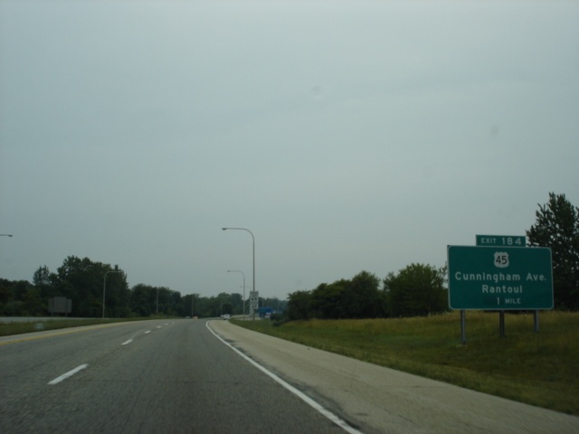
Interstate 74 West approaching Exit 184 - U.S. 45 - 1/2 mile. Rantoul (pop. 12,857) is 13 miles to the north. (Photo taken 7/11/05) |
 |
Use U.S. 45 North to the Rantoul Aviation Event Center. (Photo taken 7/11/05) |
 |
Interstate 74 West at Exit 184 - U.S. 45/Cunningham Avenue - Rantoul. (Photo taken 7/11/05) |
 |
Interstate 74 West approaching Exit 183 - Lincoln Avenue - 1 mile. Lincoln Avenue (Champaign County 52) is a north-south arterial through west Urbana. (Photo taken 7/11/05) |
 |
Use Champaign County 52 South to the University of Illinois and the Champaign County Fairgrounds. (Photo taken 7/11/05) |
 |
Interstate 74 West approaching Exit 183 - Lincoln Avenue - 1/4 mile. (Photo taken 7/11/05) |
 |
Interstate 74 West at Exit 183 - Champaign County 52/Lincoln Avenue. (Photo taken 7/11/05) |
 |
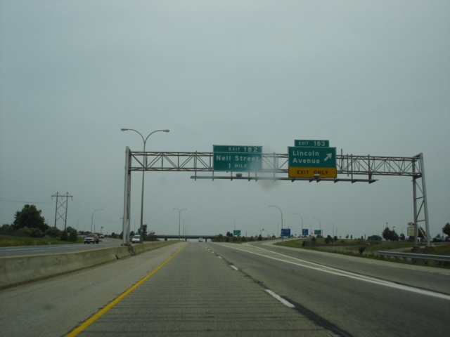
Interstate 74 West approaching Exit 182 - Neil Street - 1/2 mile. Neil Street travels through east Champaign and carries U.S. 45 from U.S. 150 southward out of the city. (Photo taken 7/11/05) |
 |
Interstate 74 West at Exit 182 - Neil Street. (Photo taken 7/11/05) |
 |
Interstate 74 West approaching Exit 181 - Prospect Avenue - 1/4 mile. Prospect Avenue carries U.S. 150 beginning less than 1/4 mile south of the interstate and extending southward for about 1.25 miles. (Photo taken 7/11/05) |
 |
Interstate 74 West at Exit 181 - Prospect Avenue. Interstate 57 is 1 1/2 miles ahead. (Photo taken 7/11/05) |
 |
Interstate 74 West approaching Exits 179A-B - Interstate 57/Interstate 72 West - 3/4 mile. Interstate 72 is mentioned from westbound Interstate 74 because it begins two miles south of the upcoming cloverleaf interchange. This is similar to eastbound Interstate 74 being signed from Interstate 72 at Interstate 57. (Photo taken 7/11/05) |
 |
Use Exit 179A to Interstate 72 West to Springfield, the capital city of Illinois. Springfield is 84 miles to the west. (Photo taken 7/11/05) |
 |
Interstate 74 West approaching Exit 179B - Interstate 57 North - 1/4 mile. Chicago is 136 miles to the north. (Photo taken 7/11/05) |
 |
Interstate 74 West at Exit 179B - Interstate 57 North - Chicago. (Photo taken 7/11/05) |
 |
Interstate 74 West at Exit 179A - Interstate 57 South - Memphis, and to Interstate 72 West - Decatur. Memphis is 401 miles to the south, and Decatur is 46 miles to the southwest. (Photo taken 7/11/05) |
| Scenes Related to Interstate 74 | |
 |
Southbound Lynch Road at Interstate 74 East - Indianapolis. The Indiana capital city is 82 miles to the east. (Photo taken 7/11/05) |
Page created: February 19, 2006
Last updated:
February 19, 2006