 |
Home Search OKRoads: |
|
|
Home Search OKRoads: |
Interstate 91 Vermont
Northbound
|
Highway Information |
|
| Miles | 177.38 |
| Counties Traveled Through |
Windham, Windsor, Orange, Caledonia, Orleans |
| Cities |
Brattleboro, St. Johnsbury, Newport |
| Major Junctions |
Interstate 89 (Exits 10N-S) Interstate 93 |
| OKRoads Coverage | |
| Miles Driven by OKRoads (Percentage) |
71 (40%) |
| Southern End of Interstate Driven |
Massachusetts State Line |
| Northern End of Interstate Driven |
Interstate 89 |
Pictures
| Interstate 91 North | |
 |
Welcome to Vermont sign on Interstate 91 North as the freeway enters the Green Mountain State. The welcome center is five miles ahead. (Photo taken 7/9/05) |
 |
Interstate 91 North approaching the rest area and Vermont welcome center - 1 mile. (Photo taken 7/9/05) |
 |
Interstate 91 North at the Windham County rest area and Vermont welcome center. (Photo taken 7/9/05) |
 |
Interstate 91 North approaching Exit 1 - U.S. 5 - 1 mile. Interstate 91 and U.S. 5 intertwine several times throughout Vermont, much like they did through Connecticut and Massachusetts. (Photo taken 7/9/05) |
 |
Use U.S. 5 North and Vermont 142 South to the town of Vernon, population 2,141. Use U.S. 5 North to Vermont 119 (and New Hampshire 119 on the east side of the Connecticut River) to Hinsdale, New Hampshire. (Photo taken 7/9/05) |
 |
Interstate 91 North at Exit 1 - U.S. 5 - Brattleboro. The town of Brattleboro has a population of 12,005, which makes it the 7th largest city in the state. The first three exits in Vermont serve the town. (Photo taken 7/9/05) |
 |
Interstate 91 North approaching Exit 2 - Vermont 9 West - 1 mile. Vermont 9 travels across the southern part of the state from Bennington to Brattleboro. (Photo taken 7/9/05) |
 |
Use Vermont 9 East to Vermont 30 and Manchester. The town is 48 miles to the northwest. (Photo taken 7/9/05) |
 |
Between Brattleboro and Bennington along Vermont 9 is the town of Marlboro, home to Marlboro College. The town of Wilmington is 20 miles to the west. (Photo taken 7/9/05) |
 |
Continue to Exit 3 for Vermont 9 East. The state highway duplexes with U.S. 5 for two miles and departs from the federal highway just east of Exit 3. (Photo taken 7/9/05) |
 |
Interstate 91 North at Exit 2 - Vermont 9 West - Brattleboro/Bennington. Vermont's 6th largest city, Bennington is 40 miles to the west. (Photo taken 7/9/05) |
 |
Interstate 91 North approaching Exit 3 - U.S. 5 and Vermont 9 East - 1 mile. Vermont changed their state highway shields within the last decade, but many of the freeway signs continue to use the old state highway shield. Until Oklahoma's recent decision to change their state highway shields, Vermont was the last state to do such a change. (Photo taken 7/9/05) |
 |
Use Exit 3 to the School for International Training, also known as SIT. (Photo taken 7/9/05) |
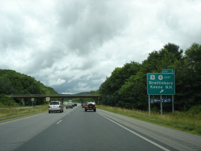 |
Interstate 91 North at Exit 3 - U.S. 5 and Vermont 9 East - Brattleboro/Keene NH. A 17 mile drive separates Brattleboro from Keene. (Photo taken 7/9/05) |
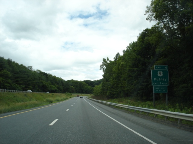 |
Interstate 91 North approaching Exit 4 - U.S. 5 - 1 mile. Exits are sparse along this stretch of Interstate 91, as there are only five exits in a 41-mile span between Exits 3 and 8. (Photo taken 7/9/05) |
 |
Interstate 91 North at Exit 4 - U.S. 5 - Putney. The town of Putney is home to 2,634 residents according to the 2000 census. (Photo taken 7/9/05) |
 |
Interstate 91 North approaching Exit 5 - Vermont 121 to U.S. 5 and Vermont 123 - 1 mile. For the first time on a BGS, the newer Vermont state highway shield appears. This sign should really read "TO U.S. 5/Vermont 121/Vermont 123," because none of these highways are directly served by this exit. The western terminus of Vermont 123, which is merely a connector between U.S. 5 and New Hampshire, is two miles from this interchange via the access road and U.S. 5 southbound. (Photo taken 7/9/05) |
 |
Interstate 91 North at Exit 5 - Access Road to U.S. 5, Vermont 121, and Vermont 123 - Westminster/Bellows Falls. Westminster is home to a station for the Green Mountain Railroad, which provides rail service through the state. (Photo taken 7/9/05) |
 |
Interstate 91 North approaching Exit 6 - U.S. 5/Vermont 103 - 1 mile. Vermont 103 begins at U.S. 5 and goes northwest 42 miles to U.S. 7 at Pierces Corners. (Photo taken 7/9/05) |
 |
The towns of Chester and Ludlow are both located along Vermont 103. (Photo taken 7/9/05) |
 |
Interstate 91 North at Exit 6 - U.S. 5/Vermont 103 - Rockingham/Rutland. Rutland is Vermont's 4th largest city and is just north of Vermont 103's northern terminus. (Photo taken 7/9/05) |
 |
A rest area with no facilities is located between exits 6 and 7 on Interstate 91 northbound. (Photo taken 7/9/05) |
 |
Interstate 91 North at the Windsor County rest area. A rest area with restroom facilities available is located just south of Interstate 89 near White River Junction. (Photo taken 7/9/05) |
 |
Interstate 91 North approaching Exit 7 - U.S. 5/Vermont 11/Vermont 106 - 1 1/2 miles. Vermont 106 begins at Vermont 11 in Springfield, which is five miles to the northwest of this interchange. (Photo taken 7/9/05) |
 |
Use Vermont 12 East to Charlestown, New Hampshire, which is just three miles to the southeast. (Photo taken 7/9/05) |
 |
Interstate 91 North approaching Exit 7 - U.S. 5/Vermont 11/Vermont 106 - 1/4 mile. (Photo taken 7/9/05) |
 |
Interstate 91 North at Exit 7 - U.S. 5/Vermont 11/Vermont 106 - Springfield. The town of Springfield is home to 9,078 residents. (Photo taken 7/9/05) |
 |
Interstate 91 North enters the town of Windsor, which is where Vermont was born in 1777. Windsor is now home to 3,756 residents. (Photo taken 7/9/05) |
 |
Interstate 91 North approaching Exit 8 - U.S. 5/Vermont 12/Vermont 131 - 1 mile. Vermont 131 meets its eastern terminus at U.S. 5 and Vermont 12 just to the east of Exit 8. (Photo taken 7/9/05) |
 |
Head west on Vermont 131 for 19 miles to Ludlow. Head east on Vermont 131 and Vermont 12 to Claremont, New Hampshire, which is five miles to the southeast. (Photo taken 7/9/05) |
 |
Interstate 91 North at Exit 8 - U.S. 5/Vermont 12/Vermont 131 - Ascutney/Windsor. Windsor is six miles to the north via U.S. 5. (Photo taken 7/9/05) |
 |
Interstate 91 North approaching Exit 9 - U.S. 5/Vermont 12 - 1 mile. The two highways duplex for 10 miles between Ascutney and Hartland. (Photo taken 7/9/05) |
 |
Interstate 91 North at Exit 9 - U.S. 5/Vermont 12 - Hartland/Windsor. In most states, this would be Exit 60, as we pass by mile marker 60 here as well. (Photo taken 7/9/05) |
 |
Mileage sign on Interstate 91 North just past Exit 9. White River Junction is 10 miles ahead, and St. Johnsbury is 72 miles away. The Canadian border is still 116 miles away. (Photo taken 7/9/05) |
 |
Interstate 91 North approaching the White River Junction rest area - 1 mile. The rest area is only open between 7 am and 11 pm. (Photo taken 7/9/05) |
 |
Interstate 91 North approaching Interstate 89 - 2 miles. Interstate 89 is Vermont's other main north-south interstate, connecting White River Junction, Montpelier, and Burlington. (Photo taken 7/9/05) |
 |
Interstate 91 North at the White River Junction rest area. (Photo taken 7/9/05) |
 |
Interstate 91 North approaching Exit 10 - Interstate 89 - 1/2 mile. The gore point signage at the interchange indicates Exit 10S for Interstate 89 southbound and Exit 10N for Interstate 89 northbound. On Interstate 89, however, the interchange does not have exit numbers. (Photo taken 7/9/05) |
 |
This diagrammatical sign shows a bit what is ahead at the Interstate 89 cloverleaf interchange. The speed limit falls to 55 through White River Junction. (Photo taken 7/9/05) |
 |
Interstate 91 North at Exit 10S - Interstate 89 South - Airport/New Hampshire. At the foot of the other end of this off-ramp, Interstate 89 begins crossing the Connecticut River into the state of New Hampshire. (Photo taken 7/9/05) |
Page created: January 17, 2006
Last updated:
January 21, 2006