 |
Home Search OKRoads: |
|
|
Home Search OKRoads: |
U.S. 69 Kansas
Northbound - Oklahoma State Line to
Louisburg
What U.S. 71 is to western Missouri is what U.S. 69 is to eastern Kansas; the major north-south route in that part of the state. U.S. 69, unlike U.S. 71, is two-laned throughout most of Kansas, but construction to widen some parts of U.S. 69 to four lanes between Fort Scott and Louisburg is underway. U.S. 69 enters Kansas north of Picher, Oklahoma, and exits Kansas just south of Interstate 635 in Kansas City. It is a freeway from 359th Street near Louisburg to Interstate 35 in Merriam.
Pictures
Northbound (Oklahoma State Line to Louisburg)
Northbound (Louisburg to Missouri State Line)
| Northbound | |
 |
U.S. 69 North as the highway enters Cherokee County. The state line also marks the southern terminus of Kansas 7, one of the longest north-south state highways in eastern Kansas. (Photo taken 5/20/05) |
 |
Welcome to Kansas sign on U.S. 69 and Kansas 7 North. The two highways are duplexed for their southernmost 12 miles in the Sunflower State. They also share a duplex in the Fort Scott area. (Photo taken 5/20/05) |
 |
Just two miles into the state, U.S. 69 and Kansas 7 meet U.S. 166. The federal highway connects U.S. 81 in South Haven to Interstate 44 near Joplin, Missouri, and stays close to the Kansas-Oklahoma border. (Photo taken 5/20/05) |
 |
U.S. 69 and Kansas 7 North at U.S. 166. Baxter Springs is five miles to the right. (Photo taken 5/20/05) |
 |
U.S. 69 and Kansas 7 North assurance shields just past U.S. 166. The highways will meet U.S. 160 in 10 miles. (Photo taken 5/20/05) |
 |
Big Brutus, a large electric mining shovel that has been turned into a museum, is located 14 miles to the north of Columbus, as this sign states on U.S. 69 and Kansas 7 northbound's entrance into Columbus. Continue on Kansas 7 North to Kansas 102 West to visit Big Brutus. (Photo taken 5/20/05) |
 |
U.S. 69 and Kansas 7 prepare to go their separate ways as they approach U.S. 160. U.S. 69 North will duplex with U.S. 160 East for 27 miles. (Photo taken 5/20/05) |
 |
U.S. 69 and Kansas 7 North at U.S. 160 East and U.S. 69 North. (Photo taken 5/20/05) |
 |
U.S. 160 East and U.S. 69 North assurance shields just east of Columbus. U.S. 160 in this area was once part of Kansas 96 before that highway was replaced with U.S. 400 for most of Kansas 96's route east of Wichita. (Photo taken 5/20/05) |
 |
Mileage sign on U.S. 160 East and U.S. 69 North just east of Columbus. Pittsburg is 24 miles ahead via both highways, as they will duplex until Frontenac, just north of Pittsburg. (Photo taken 5/20/05) |
 |
U.S. 69 North and U.S. 160 East approaching U.S. 400 and Alternate U.S. 69. Alternate U.S. 69 is the shorter route between Crestline (which is where the upcoming intersection is) and Commerce, Oklahoma. The alternate route is 21 miles between Commerce and Crestline compared to 24 miles on the mainline U.S. 69. (Photo taken 5/20/05) |
 |
U.S. 69 North and U.S. 160 East at the turnoff for U.S. 400 East and Alternate U.S. 69 South. (Photo taken 5/20/05) |
 |
U.S. 69 North and U.S. 160 East at U.S. 400/Alternate U.S. 69. Before U.S. 400, Kansas 96 continued straight ahead. Now the road is an unsigned highway to Carl Junction, Missouri. (Photo taken 5/20/05) |
 |
U.S. 69 North, U.S. 400 West, and U.S. 160 East assurance shields just north of the U.S. 69 South/U.S. 160 West intersection. The triplex of U.S. highways is 11 miles long. (Photo taken 5/20/05) |
 |
U.S. 69 North, U.S. 160 East, and U.S. 400 West approaching Kansas 103 West. Two miles separate Kansas 103 from the northern end of the U.S. highway triplex. (Photo taken 5/20/05) |
 |
U.S. 69 North, U.S. 160 East, and U.S. 400 West at Kansas 103 West. The state highway connects Kansas 7 to U.S. 69/U.S. 160/U.S. 400 and goes through the city of Weir. (Photo taken 5/20/05) |
 |
U.S. 69 North, U.S. 160 East, and U.S. 400 West approaching U.S. 400 West and Kansas 171 East. Kansas 171 was once part of Kansas 57 before that highway was truncated westward in 2002. It was renumbered to Kansas 171 because the highway connecting to it five miles to the east is Missouri 171. (Photo taken 5/20/05) |
 |
U.S. 69 North, U.S. 160 East, and U.S. 400 West at U.S. 400 West and Kansas 171 East. (Photo taken 5/20/05) |
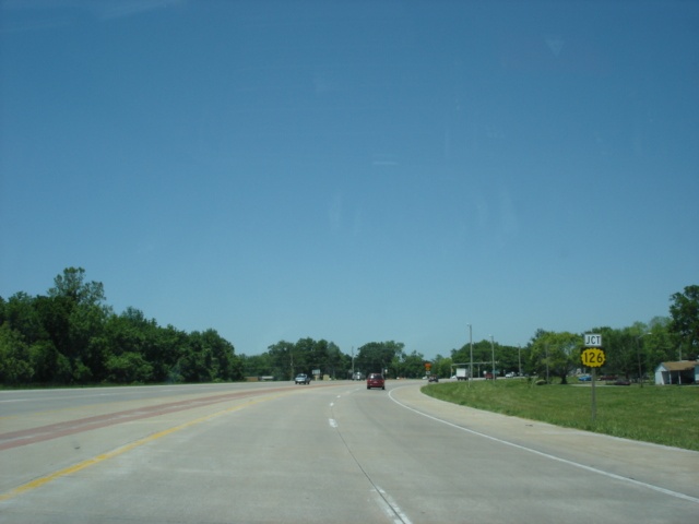 |
U.S. 69 North and U.S. 160 East approaching Kansas 126 in Pittsburg. The state highway changes states but not numbers at the Missouri State Line, which is six miles to the east of the upcoming intersection. (Photo taken 5/20/05) |
 |
U.S. 69 North and U.S. 160 East at Kansas 126. Turning right will put one into downtown Pittsburg. Not nearly as famous as Pittsburgh, Pennsylvania, Pittsburg, Kansas, is home of Pittsburg State University, home of the Division II football that finished 2nd in 2004. (Photo taken 5/20/05) |
 |
U.S. 69 North and U.S. 160 East approaching Business U.S. 69 in north Pittsburg. U.S. 69 and U.S. 160 make a left turn ahead. This is the first warning of the left turn, which can cause some last second lane changes. The first time I drove in Pittsburg, I almost caused an accident here because of this. (Photo taken 5/20/05) |
 |
U.S. 69 North and U.S. 160 East at Business U.S. 69 South. (Photo taken 5/20/05) |
 |
Just one mile north of the business route is the split of U.S. 69 and U.S. 160, located in Frontenac. (Photo taken 5/20/05) |
 |
U.S. 69 North and U.S. 160 East split here. Frontenac has a population of nearly 3,000. (Photo taken 5/20/05) |
 |
U.S. 69 North approaching Kansas 47 West and Business U.S. 69 North - 1/2 mile. Kansas 47 is a newly extended highway, as it replaced Kansas 57 from U.S. 59 to U.S. 69. (Photo taken 5/20/05) |
 |
U.S. 69 North approaching Kansas 47. Notice that Business U.S. 69 is unsigned here. (Photo taken 5/20/05) |
 |
U.S. 69 North at Kansas 47 West/Business U.S. 69 North. The business route goes through the cities of Arma and Franklin. Franklin made the news in May 2003 when a tornado heavily damaged the city. (Photo taken 5/20/05) |
 |
U.S. 69 North approaching Business U.S. 69 South in Arma. (Photo taken 5/20/05) |
 |
U.S. 69 North at Business U.S. 69 South. (Photo taken 5/20/05) |
 |
U.S. 69 North approaching Kansas 7 South - 1/2 mile. The two highways are duplexed again near Fort Scott. (Photo taken 5/20/05) |
 |
U.S. 69 North at Kansas 7 South. Only an assurance shield points the way to the state highway. Girard is 22 miles to the south on Kansas 7, and Chanute is 44 miles west via Kansas 39. (Photo taken 5/20/05) |
 |
Mileage sign on U.S. 69 and Kansas 7 North. Fort Scott is two miles ahead, and Kansas City is 89 miles away. (Photo taken 5/20/05) |
 |
Reduced speed ahead sign as U.S. 69 and Kansas 7 North enter Fort Scott. This is the new standard sign for reduced speed ahead, according to the latest edition of the Manual of Uniform Traffic Control Devices (M.U.T.C.D.). (Photo taken 5/20/05) |
 |
U.S. 69 and Kansas 7 North approaching U.S. 54 East - Fort Scott/Nevada, MO. A stoplight is located ahead at 3rd Street in Fort Scott. (Photo taken 5/20/05) |
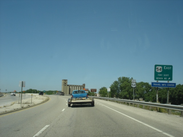 |
U.S. 69 and Kansas 7 North at U.S. 54 East. Nevada is located 19 miles to the east and is pronounced Nev-eh-da, not Nev-ah-da like the state. (Photo taken 5/20/05) |
 |
U.S. 54 West, U.S. 69 North, and Kansas 7 North approaching U.S. 54 West/Kansas 7 North - 1/2 mile. (Photo taken 5/20/05) |
 |
U.S. 54 West, U.S. 69 North, and Kansas 7 North assurance shields just north of Fort Scott. (Photo taken 5/20/05) |
 |
U.S. 54 West, U.S. 69 North, and Kansas 7 North at U.S. 54 West/Kansas 7 North. Wichita, the largest city in Kansas, is 153 miles west of Fort Scott. (Photo taken 5/20/05) |
 |
U.S. 69 was under construction north of Fort Scott to widen the highway to four lanes. The first exit on this newly widened section is at Poplar Road. Previously, the highway was a Super-2. (Photo taken 5/20/05) |
 |
U.S. 69 North at Kansas 31 North. Kansas 31 begins here and enters Fulton just west of U.S. 69. The highway zigzags its way to the northwest and sees its other terminus at Kansas 99 near Eskridge. (Photo taken 5/20/05) |
 |
U.S. 69 North approaching Kansas 239 - 1/2 mile. The state highway connects U.S. 69 to the Missouri state line, where it becomes State Supplemental Route A. (Photo taken 5/20/05) |
 |
U.S. 69 North at Kansas 239 - Prescott. This marks the current northern terminus of the U.S. 69 freeway. (Photo taken 5/20/05) |
 |
U.S. 69 North approaching Kansas 52. The two highways will be duplexed for the next eight miles. (Photo taken 5/20/05) |
 |
U.S. 69 North at Kansas 52 West. Five miles to the west lies Mound City, where I spent some time visiting family who lived there in the late 1990s. (Photo taken 5/20/05) |
 |
U.S. 69 North and Kansas 52 East approaching Linn Country 552. This is the only county road intersection signed along U.S. 69 throughout Kansas. (Photo taken 5/20/05) |
 |
U.S. 69 North and Kansas 52 East at Linn County 552. (Photo taken 5/20/05) |
 |
U.S. 69 North and Kansas 52 East approaching their split. The area near this intersection is home to a trading post. (Photo taken 5/20/05) |
 |
U.S. 69 North and Kansas 52 East at Kansas 52 East. Butler, Missouri, is 19 miles to the east via Kansas and Missouri 52. (Photo taken 5/20/05) |
 |
A diamond interchange is located at U.S. 69 and Kansas 152. The state highway connects Kansas 7 to U.S. 69. (Photo taken 5/20/05) |
 |
Head eastward from U.S. 69 for two miles to La Cygne Lake, home of La Cygne State Park. (Photo taken 5/20/05) |
 |
U.S. 69 North at Kansas 152. The city of La Cygne is four miles west of U.S. 69. (Photo taken 5/20/05) |
 |
Mileage sign on U.S. 69 just past Kansas 152. Louisburg, located at the interchange of U.S. 69 at Kansas 68, is 20 miles ahead. (Photo taken 5/20/05) |
 |
As motorists enter Miami County, the two lane road widens to a four-lane freeway. It was widened to four lanes between Kansas 68 and the Miami/Linn county line in 2003 and 2004. The first northbound exit serves 359th Street, one mile. The Kansas City street numbering begins in Miami County. (Photo taken 5/20/05) |
 |
U.S. 69 North approaching 359th Street, one-half mile. (Photo taken 5/20/05) |
 |
U.S. 69 North at 359th Street. Taking 359th Street east to Missouri will lead to the eastbound beginning of Missouri 18. (Photo taken 5/20/05) |
 |
U.S. 69 North approaching 335th Street, one mile. (Photo taken 5/20/05) |
 |
U.S. 69 North approaching 335th Street, one-half mile. The speed limit is 70 miles per hour on the freeway until reaching 135th Street in Overland Park. (Photo taken 5/20/05) |
 |
U.S. 69 North at 335th Street. (Photo taken 5/20/05) |
 |
U.S. 69 North approaching 311th Street, one mile. (Photo taken 5/20/05) |
 |
U.S. 69 North approaching 311th Street, one-half mile. (Photo taken 5/20/05) |
 |
Take 311th Street westbound for nine miles to Paola. (Photo taken 5/20/05) |
 |
U.S. 69 North at 311th Street. (Photo taken 5/20/05) |
 |
U.S. 69 North approaching Kansas 68 - 1 mile. (Photo taken 5/20/05) |
 |
Take Kansas 68 West three miles to visit the Louisburg Cider Mill, which offers more than just apple cider. (Photo taken 5/20/05) |
 |
U.S. 69 North approaching Kansas 68, one-half mile. (Photo taken 5/20/05) |
 |
U.S. 69 North at Kansas 68. Louisburg is located just east of this interchange, and Ottawa is 31 miles west of Louisburg. This interchange is also home to the only fast-food restaurants between Fort Scott and Overland Park. (Photo taken 5/20/05) |
 |
View at the end of the Kansas 68 off-ramp. Development has surged here in recent years, with a grocery store, two gas stations, and two fast food restaurants among the real estate here. I've also spent a lot of time in the Louisburg area visiting family. (Photo taken 5/20/05) |
Page created: August 15, 2005
Last updated:
August 16, 2005