 |
Home Search OKRoads: |
|
|
Home Search OKRoads: |
Interstate 190 New York
Northbound
Interstate 190 connects Interstate 90 to downtown Buffalo and Niagara Falls. It is 28 miles long and is one of two three-digit interstates to enter a foreign country. (Interstate 110 in El Paso, Texas, is the other, and that route is hidden) There are two toll booths along the way; one in Buffalo and the other for the bridge to Grand Island.
|
Highway Information |
|
| Miles | 28.34 |
| Counties Traveled Through |
Erie, Niagara |
| Cities | Buffalo, Niagara Falls |
| Major Junctions |
Interstate 90
Interstate 290 |
| OKRoads Coverage | |
| Miles Driven by OKRoads (Percentage) |
28 (100%) |
| Southern End of Interstate Driven |
Interstate 90 |
| Northern End of Interstate Driven |
Canadian border |
Pictures
| Interstate 190 North | |
 |
Interstate 190 North begins with a toll booth. Cars pay 75 cents at the toll booth. Mile marker N00 is also posted here. All mile markers on Interstate 190 begin with "N" because it is the Niagara section of the New York State Thruway. (Photo taken 7/10/05) |
 |
Interstate 190 North approaching Exit 1 - South Ogden Street/Dingen Street - 1/2 mile. This is the only BGS prior to the Exit 1 off-ramp. (Photo taken 7/10/05) |
 |
Interstate 190 North at the Buffalo toll plaza. (Photo taken 7/10/05) |
 |
Interstate 190 North at Exit 1 - South Ogden Street/Dingen Street. Ogden Street is the overpass in the distance. Dingen Street runs just to the north of this interchange and is directly served by the northbound ramps. Interstate 190 northbound travels west until reaching downtown Buffalo. (Photo taken 7/10/05) |
 |
Interstate 190 North approaching Exit 2 - New York 354/Clinton Street and U.S. 62/Bailey Avenue - 1 mile. The interchange directly serves New York 354; head west on Clinton Street to U.S. 62. (Photo taken 7/10/05) |
 |
Interstate 190 North assurance shield between Exit 1 and Exit 2. (Photo taken 7/10/05) |
 |
Interstate 190 North at Exit 2 - New York 354/Clinton Street and U.S. 62/Bailey Avenue. (Photo taken 7/10/05) |
 |
Interstate 190 North approaching Exit 4 - Smith Street/Fillmore Avenue - 1 mile. Exit 3 is a southbound-only exit to Elk Street. (Photo taken 7/10/05) |
 |
Interstate 190 North at Exit 4 - Smith Street/Fillmore Avenue. Smith Street spawns off Fillmore Avenue 1/4 mile to the north of Interstate 190. (Photos taken 7/10/05) |
 |
|
 |
Interstate 190 North at Exit 5 - Hamburg Street. Hamburg Street is a short north-south arterial through central Buffalo. (Photo taken 7/10/05) |
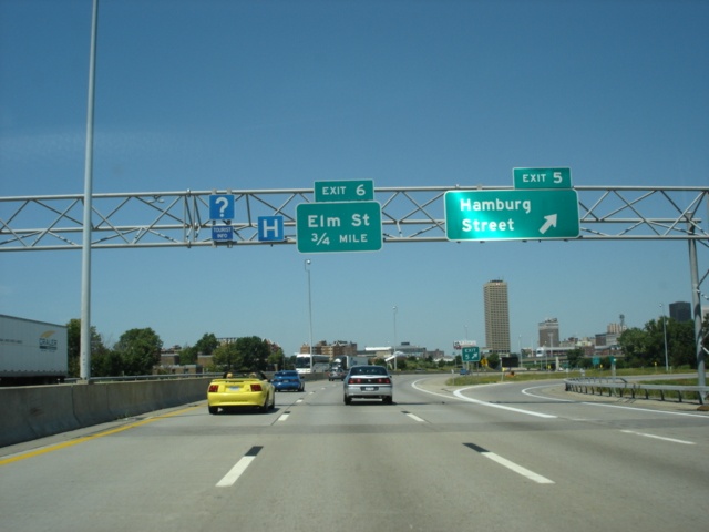 |
The Exit 5 off-ramp to Hamburg Street departs in this view as the 3/4 mile advance sign for Exit 6, Elm Street, is posted. Elm Street provides the first main entrance into downtown Buffalo from Interstate 190 northbound. (Photo taken 7/10/05) |
 |
Use Exit 6 to Dunn Tire Park, home of the Buffalo Bisons AAA baseball team, and to the HSBC Arena, home of the National Hockey League's Buffalo Sabres. (Photo taken 7/10/05) |
 |
Use any of the next three exits to downtown Buffalo. (Photo taken 7/10/05) |
 |
Interstate 190 North at Exit 6 - Elm Street. Dunn Tire Park is just to the right of this view. (Photo taken 7/10/05) |
 |
Interstate 190 North approaching Exit 7 - Church Street - 3/4 mile. The interstate begins heading to the north here as it nears the beginning of the east-west arterial. (Photo taken 7/10/05) |
 |
Interstate 190 North at Exit 7 - Church Street. Use Church Street eastbound to northbound Delaware Avenue to the Buffalo city government complex. (Photo taken 7/10/05) |
 |
Interstate 190 North approaching Exit 8 - New York 266/Niagara Street - 1/8 mile. The state highway parallels Interstate 190 for much of its distance. (Photo taken 7/10/05) |
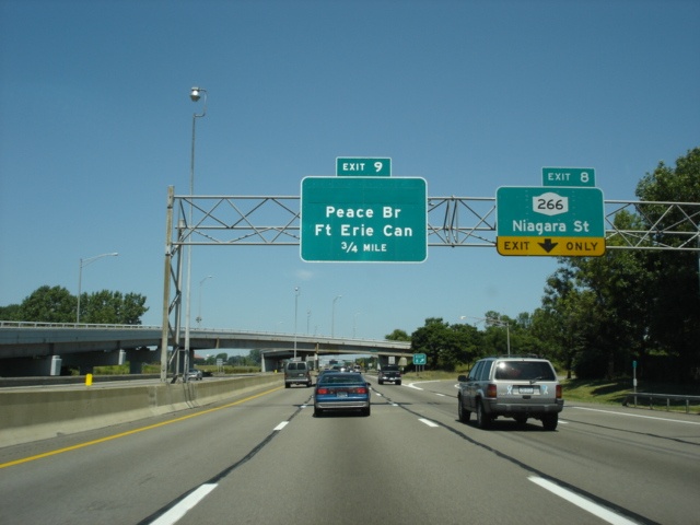 |
Interstate 190 North at Exit 8 - New York 266/Niagara Street. The next exit is Exit 9, Peace Bridge, 3/4 mile. (Photo taken 7/10/05) |
 |
Interstate 190 North approaching Exit 9 - Peace Bridge - 1/8 mile. Fort Erie, Canada, is located just west of the Niagara River, which begins just behind the foliage to the left. (Photo taken 7/10/05) |
 |
Interstate 190 North at Exit 9 - Peace Bridge/Fort Erie, Canada. (Photo taken 7/10/05) |
 |
There is another ramp to Niagara Street from the Exit 9 off-ramp. The overpass seen here carries traffic from the Peace Bridge to Interstate 190 South. (Photo taken 7/10/05) |
 |
A look at the Peace Bridge from Interstate 190 North. The toll is $2.50 U.S. and $3.50 Canadian. Those with E-ZPass receive a 30% discount. (Photo taken 7/10/05) |
 |
Interstate 190 North approaching Exit 11 - New York 198 - 1 mile. New York 198 is also known as the Scajaquada Expressway, connecting Interstate 190 to New York 33 (Kensington Expressway). One of New York's famous "state speed limit" signs is posted here as well. (Photo taken 7/10/05) |
 |
Southbound travelers pay their 75-cent toll at this toll plaza between the Peace Bridge and the Scajaquada Expressway. This is the same toll northbound motorists paid before Exit 1. (Photo taken 7/10/05) |
 |
Interstate 190 North approaching Exit 11 - New York 198/Scajaquada Expressway - 1/4 mile. Interstate 190 squeezes in between the Niagara River and Buffalo between exits 8 and 14. (Photo taken 7/10/05) |
 |
Interstate 190 North at Exit 11 - New York 198/Scajaquada Expressway. The state highway is three miles long. (Photo taken 7/10/05) |
 |
Interstate 190 travels underneath a railroad bridge just north of New York 198. (Photo taken 7/10/05) |
 |
Interstate 190 North at Exit 12 - Amherst Street. Amherst Street is an east-west arterial through northern Buffalo. (Photo taken 7/10/05) |
 |
Interstate 190 North at Exit 13 - Austin Street. Exit 12 and Exit 13 are both northbound-only exits. Austin Street is a short east-west connector between Interstate 190 and New York 265. (Photo taken 7/10/05) |
 |
Interstate 90 North approaching Exit 14 - Vulcan Street - 1 mile. Trucks weighing over 5 tons are prohibited from using this exit. (Photo taken 7/10/05) |
 |
Interstate 190 North approaching Exit 14 - Vulcan Street - 1/2 mile. (Photo taken 7/10/05) |
 |
Interstate 190 North at Exit 14 - Vulcan Street. Just to the right is New York 266/Niagara Street. (Photo taken 7/10/05) |
 |
Interstate 190 travels underneath the Rene K. Gardner Pedestrian Bridge at Riverside Park in this view. (Photo taken 7/10/05) |
 |
Mileage sign on Interstate 190 North just past Exit 14. Grand Island is five miles ahead, and Niagara Falls is 10 miles away. (Photo taken 7/10/05) |
 |
Interstate 190 North approaching Exit 15 - New York 324 - 1 mile. New York 324 begins at Interstate 190's Exit 20 on Grand Island and parallels the interstate on the island before heading to the mainland. The off-ramp leads to New York 325, a short connector route between New York 286 and New York 324. (Photo taken 7/10/05) |
 |
Interstate 190 North approaching Exit 16 - Interstate 290 East - 1 mile. Interstate 290 connects Interstate 190 to Interstate 90 and goes through Tonawanda, Amherst, and Snyder. (Photo taken 7/10/05) |
 |
Interstate 190 North at Exit 15 - New York 324 - Sheridan Drive/Kenmore Avenue. Motorists will be on Sheridan Drive once they depart this off-ramp, but it will be on New York 325 until they reach New York 324. (Photo taken 7/10/05) |
 |
Interstate 190 North approaching Exit 16 - Interstate 290 East - 1/2 mile. (Photo taken 7/10/05) |
 |
Interstate 190 North at Exit 16 - Interstate 290 East to Interstate 90 - Tonawanda/Rochester. A 75 mile eastbound drive awaits those going to Rochester. (Photo taken 7/10/05) |
 |
Interstate 190 North approaching Exit 17 - New York 266/River Road - 1 mile. To the right, we see the off-ramp to Interstate 290 East. Traffic from New York 324 uses the same ramp and are given the chance to get onto either Interstate 190 North or Interstate 290 East. (Photo taken 7/10/05) |
 |
Interstate 190 North assurance shield and one-mile advance signage for the toll booths for the Grand Island bridge. The town of Grand Island is home to 18,621 residents. Town residents are given a discount to use the bridge, as both ways into town via automobile are on toll bridges on Interstate 190. (Photo taken 7/10/05) |
 |
Interstate 190 North approaching Exit 17 - New York 266/River Road - 1/4 mile. (Photo taken 7/10/05) |
 |
Interstate 190 North at Exit 17 - New York 266/River Road - Tonawandas. Tonawandas refers to the twin cities of Tonawanda and North Tonawanda. Tonawanda has a population advantage over its "child", with 78,155 residents versus 33,262. (Photo taken 7/10/05) |
 |
Gore point signage at Exit 17 as the Grand Island toll bridge plaza comes into view. (Photo taken 7/10/05) |
| Interstate 190 North and New York 324 West | |
 |
Interstate 190 North and New York 324 West duplex on the Grand Island bridge. The duplex is unsigned on northbound/westbound. Six lanes are available at this toll plaza, with the outside lanes used as E-ZPass only lanes, and the remaining four used as cash lanes. (Photo taken 7/10/05) |
 |
Interstate 190 North as it ascends to cross the Niagara River's eastern branch onto Grand Island. Both bridges carry two narrow lanes with little shoulder to speak of. (Photo taken 7/10/05) |
 |
A view of Grand Island from the bridge. (Photo taken 7/10/05) |
 |
New York 324 West departs from Interstate 190 North at Exit 18A. The state highway is known as Grand Island Boulevard and stays just east of Interstate 190 throughout the island. New York 324 ends at Interstate 190 in north Grand Island. (Photo taken 7/10/05) |
 |
Interstate 190 North and New York 324 West at Exit 18A - New York 324 West/Grand Island Boulevard. Niagara Falls is five miles away. These signs use an unusual font throughout. (Photo taken 7/10/05) |
| Interstate 190 North | |
 |
Interstate 190 North at Exit 18B - Beaver Island State Park. The park takes up 950 acres at the southern tip of the island. (Photo taken 7/10/05) |
 |
Interstate 190 North approaching Exit 19 - Whitehaven Road - 3/4 mile. Whitehaven Road is the main east-west arterial on the island, extending six miles across the island's widest point. (Photo taken 7/10/05) |
 |
Interstate 190 North at Exit 19 - Whitehaven Road. (Photo taken 7/10/05) |
 |
Interstate 190 North approaching Exit 20 - Long Road - 3/4 mile. Long Road is an east-west arterial in north Grand Island. Bedell Road crosses the interstate in this view. (Photo taken 7/10/05) |
 |
Interstate 190 North at Exit 20 - Long Road. (Photo taken 7/10/05) |
 |
Use Exit 21 to westbound Robert Moses State Parkway to the Seneca Niagara Casino, located on the shores of the Niagara River near the world-famous falls. (Photo taken 7/10/05) |
 |
Interstate 190 North departs Grand Island and enters the city of Niagara Falls as this mileage sign appears for the next three exits. The first Niagara Falls exit is Exit 21 in one mile at New York 384 and the Robert Moses State Parkway. (Photo taken 7/10/05) |
 |
Interstate 190 North approaching Exit 21 - Robert Moses State Parkway/New York 384 - 1/2 mile. The Robert Moses State Parkway travels along the shores of the Niagara River from Interstate 190 westward through Niagara Falls, then travels north to New York 18 near Youngstown. (Photo taken 7/10/05) |
 |
Head west on the Robert Moses State Parkway to the Niagara Reservation State Park and the American Falls, which is what Niagara Falls is most known for. (Photo taken 7/10/05) |
 |
Interstate 190 North at Exit 21 - Robert Moses State Parkway and New York 384/Buffalo Avenue. New York 384 travels through Buffalo, the Tonawandas, and Niagara Falls along its journey. (Photo taken 7/10/05) |
 |
Interstate 190 North at Exit 21A - LaSalle Expressway - Tonawandas. The LaSalle Expressway provides a freeway connection between Interstate 190 and Williams Road 2 1/2 miles to the east. (Photo taken 7/10/05) |
 |
Interstate 190 North approaching Exit 22 - U.S. 62 - 1/2 mile. Niagara Falls Boulevard provides a toll-free connection between Buffalo and Niagara Falls. (Photo taken 7/10/05) |
 |
Interstate 190 North at Exit 22 - U.S. 62/Niagara Falls Boulevard - Business District/Airport. The Niagara Falls International Airport is three miles to the east. Prime Outlets Niagara Falls is just to the north. (Photo taken 7/10/05) |
 |
Interstate 190 North approaching Exit 23 - New York 182 - 1 mile. The state highway travels along Porter Road, Ontario Avenue, and Cleveland avenue through Niagara Falls. (Photo taken 7/10/05) |
 |
Interstate 190 North approaching Exit 23 - New York 182 - 1/2 mile. Packard Road goes northeast from this interchange and connects to Lockport Road one mile from the interstate. (Photo taken 7/10/05) |
 |
Interstate 190 North at Exit 23 - New York 182 - Porter Road/Packard Road. (Photo taken 7/10/05) |
 |
Interstate 190 North approaching Exit 24 - New York 31 - 1 mile. New York 31 begins at New York 104 two miles to the west of Interstate 190 and heads east to New York 26 in Vernon Center. (Photo taken 7/10/05) |
 |
Interstate 190 North approaching Exit 24 - New York 31 - 1/2 mile. (Photo taken 7/10/05) |
 |
Use eastbound New York 31 to Niagara County Community College. Continue to Exit 25A (New York 265) to Niagara University. (Photo taken 7/10/05) |
 |
Interstate 190 North at Exit 24 - New York 31/Witmer Road. (Photo taken 7/10/05) |
 |
Interstate 190 North approaching Exits 25A-B - New York 104/New York 265/Robert Moses State Parkway - 1 mile. The cloverleaf interchange directly serves New York 265 and Niagara County 11 (Upper Mountain Road). Niagara County 11 connects to New York 104 and the Robert Moses State Parkway to the southwest of the interchange. (Photo taken 7/10/05) |
 |
Use Exit 25A to Niagara University and to the Earl W. Brydges Artpark State Park. (Photo taken 7/10/05) |
 |
Use Exit 25B to New York 104 eastbound to the village of Youngstown. Use the northbound Robert Moses State Parkway to Fort Niagara State Park. (Photo taken 7/10/05) |
 |
Interstate 190 North at Exit 25A - New York 265 - Lewiston. This exit directly connects to the state highway unlike the other ramps at this interchange. The town of Lewiston is three miles to the north. (Photo taken 7/10/05) |
 |
Interstate 190 North at Exit 25B - New York 104 - Robert Moses State Parkway. The customs checkpoint is just ahead. This is the final United States exit of Interstate 190. (Photo taken 7/10/05) |
 |
Shifting to views from Niagara County 11, we see the off-ramp to Interstate 190 South to Niagara Falls and Buffalo. However, the best way to Niagara Falls is to continue straight ahead and take either New York 104 westbound or the southbound Robert Moses State Parkway. (Photo taken 7/10/05) |
 |
Use northbound Robert Moses State Parkway to Fort Niagara. (Photo taken 7/10/05) |
 |
Westbound Niagara County 11 at New York 104 East - Lewiston. Continue straight ahead to either direction of the Robert Moses State Parkway. (Photo taken 7/10/05) |
 |
Westbound Niagara County 11 concludes as ramps to the Robert Moses State Parkway split. Commercial traffic is prohibited from using the parkway. (Photo taken 7/10/05) |
Selected Links
Interstate 190 New York @ NorthEastRoads.com (Andy Field/Alex Nitzman)
Page created: January 28, 2006
Last updated:
January 29, 2006