 |
Home Search OKRoads: |
|
|
Home Search OKRoads: |
Interstate 30
Interstate 30 provides access between Fort Worth, Dallas, Texarkana, and Little Rock. The shortest Interstate x0 at a length of just 367 miles, Interstate 30 spends most of those miles in the Lone Star State of Texas
From its beginning at Interstate 20 west of Fort Worth, Interstate 30 spends its first five miles in a rural area. Once it meets Interstate 820 for the first time, however, the surrounding area changes drastically, and Interstate 30 becomes the main highway from Fort Worth to Dallas. This stretch of highway was originally the Dallas-Fort Worth Turnpike. The interchanges at TX 360 and Loop 12 have their unusual design because of the highway's original configuration. (Plus, it would be very very very expensive to redo the interchanges!) The highway maintains three lanes in each direction from the western Interstate 820 junction (Exit 5) to TX 205 (Exit 68).
After leaving Dallas behind, the highway continues northeast as it heads through Greenville, Sulphur Springs, Mount Pleasant, and Texarkana. After intersecting U.S. 59 and U.S. 71 at Exits 223A-B, Interstate 30 enters the state of Arkansas. About 30 miles later, the highway has two interchanges for the city of Hope, the birthplace of former President Bill Clinton. Interstate 30 then makes its way towards Arkadelphia, which is a gateway of sorts for the Hot Springs area. A cloverleaf interchange is in place at U.S. 270 at mile marker 98. U.S. 70 joins the interstate at mile marker 111, and are duplexed to Little Rock. A resurfacing project is well underway on Interstate 30 from mile marker 117 to mile marker 133. Two lanes are allotted in each direction and the highway has a 55 mph speed limit. After leaving the construction area, Interstate 30 heads to the north at the beginning of both Interstate 440 and Interstate 530. Interstate 30 then heads through the east part of downtown Little Rock, crosses over the Arkansas River, and finds its eastern end at Interstate 40 in North Little Rock.
|
Highway Information |
|
| States Traveled
Through (Mileage in state) |
Texas (223.74) Arkansas (143.02) |
| Total Mileage | 366.76 |
| Cities | Texas: Ft. Worth, Dallas, Greenville, Sulphur Springs, Mt. Pleasant, Texarkana Arkansas: |
| Source | 10/31/02 Interstate Route Log & Finder List |
| OKRoads Coverage | |
| Miles Driven by OKRoads (Percentage) |
367 (100%) |
| Western End of Interstate Driven |
Interstate 20 |
| Eastern End of Interstate Driven |
Interstate 40 |
Selected Pictures
For more pictures of Interstate 30 from a particular
state, click on the state below.
| Texas | |
 |
Interstate 30 East at Exit 5B - Interstate 820 North. (Photo taken 7/14/04) |
 |
Interstate 30 East approaching Exit 15A - Interstate 35W/U.S. 377 North - 1/2 mile. The exit tab mistakenly says Exit 15B, which is actually for U.S. 287 South. (Photo taken 7/14/04) |
 |
Interstate 30 East at Exit 44B - TO Interstate 35E South - Industrial Blvd. (Photo taken 7/14/04) |
 |
Interstate 30 East at Exit 46 -
Interstate 45/U.S. 75 - Houston/Sherman. (Photo taken 7/14/04) |
 |
Interstate 30 East at Exit 53B -
U.S. 80 East - Terrell. This is the western terminus of the federal route. (Photo taken 7/14/04) |
 |
Interstate 30 East at Exit 56C - Interstate 635 South. (Photo taken 7/14/04) |
 |
Interstate 30 East at Exit 223A -
U.S. 71 South - State Line Avenue. (Photo taken 7/14/04) |
| Arkansas | |
 |
Interstate 30 East at
Exit 2 - AR 245 - Airport. This interchange is currently a diamond interchange, but may be converted to a high-speed interchange in the future. AR 245 is a 4-lane freeway from here southward and may eventually become either Interstate 49 or Interstate 130. (Photo taken 7/14/04) |
 |
Interstate 30 East at
Exit 98A - U.S. 270 East - Malvern. (Photo taken 7/14/04) |
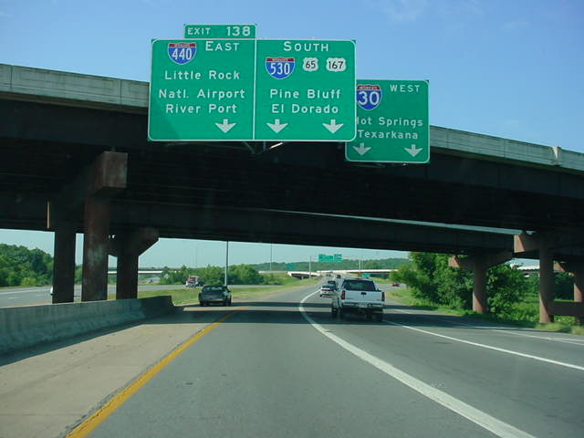 |
Interstate 30 West at
Exit 138 - Interstate 440 East - Little Rock National Airport/River Port. (Photo taken 7/15/04) |
 |
Interstate 30 West at
Exit 139B - Interstate 630. (Photo taken 7/15/04) |
 |
Interstate 30 East at
Exit 143A - Interstate 40 West/U.S. 65/AR 107 North - Fort Smith, and Exit 143B - Interstate 40 East/U.S. 67/ U.S. 167 North - Memphis. Traffic in the other direction was backed up due to an accident near the 15th St. exit. (Photo taken 7/15/04) |
Highway Links
Interstate 30 Lancaster Street Elevated Demolition (Erik Slotboom)
Page created: February 24, 2005
Last updated:
February 24, 2005