|
Home Search OKRoads: |
|
|
Home Search OKRoads: |
Interstate 435 Kansas
Interstate 435 is the outer beltway around Kansas City. It is about 83 miles long overall, which makes it the second longest beltway in the country, behind only Interstate 275 around Cincinnati.
|
Highway Information |
|
| Miles | 28.03 |
| Counties Traveled Through |
Johnson, Wyandotte |
| Cities | Kansas City |
| Major Junctions |
Interstate 70 (Exit 12) Kansas
10 Interstate 35 U.S. 69 |
| OKRoads Coverage | |
| Miles Driven by OKRoads (Percentage) |
28 (100%) |
| Southern End of Interstate Driven |
Missouri State Line |
| Northern End of Interstate Driven |
Missouri State Line |
Pictures
| Inner Loop | |
 |
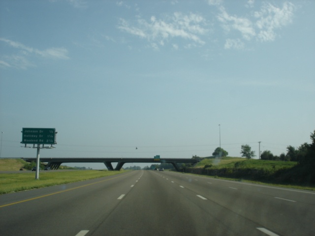
Interstate 435 West at the
Kansas-Missouri state line. The interstate will stay in Johnson County until Exit 8A (Holliday Drive). (Photo taken 5/22/05) |
 |
Close up view of Interstate 435
West approaching Exits 77A-B - Roe Avenue/Nall Avenue. (Photo taken 5/22/05) |
 |
Welcome to Kansas sign on
Interstate 435 West, one-half mile west of Exits 77A-B. (Photo taken 5/22/05) |
 |
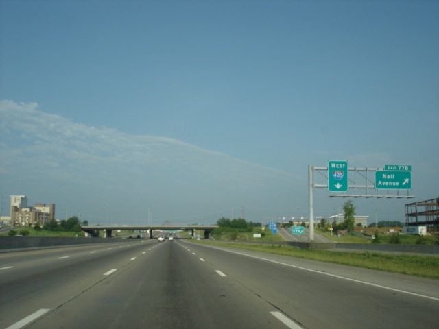
Interstate 435 West at Exit 77A -
Roe Avenue, and Exit 77B - Nall Avenue. A collector-distributor system eases the movements between the interstate and the arterials. (Photo taken 5/22/05) |
 |
Interstate 435 West c/d lane at
Exit 77A - Roe Avenue. (Photo taken 5/22/05) |
 |
Attached to the Roe Avenue
overpass is the 1 1/4 mile advance signage for U.S. 169 North and Metcalf Avenue. (Photo taken 5/22/05) |
 |
Interstate 435 West c/d lane at
Exit 77B - Nall Avenue. (Photo taken 5/22/05) |
 |
Mileage sign on Interstate 435
West, 1/2 mile east of U.S. 169 North. (Photo taken 5/22/05) |
 |
Interstate 435 West approaching
Exit 79 - U.S. 169 North/ Metcalf Avenue - 1/4 mile. Several office structures are located near this interchange. (Photo taken 5/22/05) |
 |
Interstate 435 West at Exit 79 -
U.S. 169 North/Metcalf Avenue. U.S. 169 will multiplex with Interstate 435 and U.S. 50 for four miles until departing on Interstate 35 South. (Photo taken 5/22/05) |
 |
Interstate 435 West approaching
Exit 81 - U.S. 69 - 1 3/4 miles. We did not get any other pictures of the advance signage for the cloverleaf exchange of the two freeways. (Photo taken 5/22/05) |
 |
Interstate 435 West approaching
Exit 82 - Quivira Road - 3/4 mile. The c/d lane ramp to U.S. 69 South is to the right. (Photo taken 5/22/05) |

|
Closer views of the U.S. 69
South exit from the c/d lane. (Top photo taken 7/2/03, bottom photo taken 5/21/05) |
 |
Use
Exit 82 to go to the
University of Kansas' Edwards campus or to the Johnson County Community College. (Photo taken 5/21/05) |

|
Mileage sign on
Interstate 435 West, 1 1/2
miles to the east of Interstate 35. Sometime between July 2003 and May 2005, a sound barrier was installed along the north side of the interstate. (Top photo taken 7/2/03, bottom photo taken 5/21/05) |

|
Interstate 435 West
at Exit 82 - Quivira
Road. The right lane, which merged on from U.S. 69, is an exit only lane, except that no signs tell you so! I found out the hard way. This happens on both sides of the interstate. (Top photo taken 7/2/03, bottom photo taken 5/21/05) |
 |
Interstate 435 West approaching
Exit 83 - Interstate 35 - 1 mile. (Photo taken 5/21/05) |

|
Mileage sign on
Interstate 435 West, 1/2
mile to the east of Interstate 35. (Top photo taken 7/2/03, bottom photo taken 5/21/05) |

|
Interstate 435 West
approaching Exit 83 -
Interstate 35 - 1/4 mile. (Top photo taken 7/2/03, bottom photo taken 5/21/05) |

|
Interstate 435 West
at Exit 83 - Interstate
35 - Wichita/Des Moines. (Photo taken 7/2/03) |

|
The split of the
off-ramp for Exit 83.
Wichita is about 180 miles away from this interchange. (Photo taken 7/2/03) |
 |
Interstate 435 West approaching Exit 1A - Lackman Road - 1/4 mile. (Photo taken 5/21/05) |

|
Interstate 435 West
at Exit 1A - Lackman Road. (Top photo taken 7/1/03, bottom photo taken 5/21/05) |
 |
Interstate 435 West approaching Exit 1B - Kansas 10 - 1/4 mile. Use Kansas 10 West as an alternate to the Kansas Turnpike between Kansas City and Lawrence. (Photo taken 5/21/05) |

|
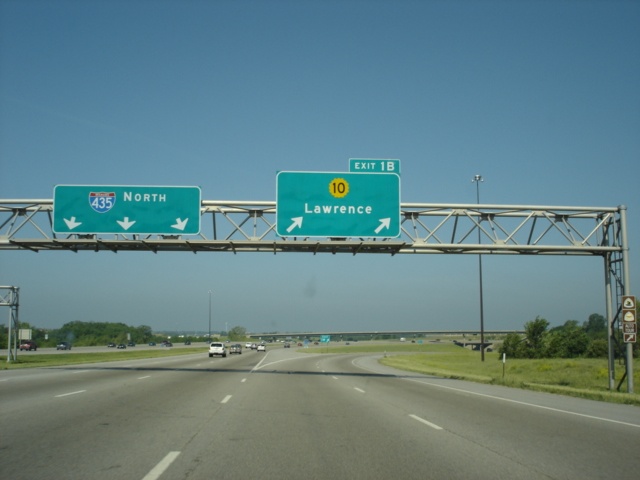
Interstate 435 West
at Exit 1B - K-10 - Lawrence. (Top photo taken 7/1/03, bottom photo taken 5/21/05) |
 |
Interstate 435 North approaching Exit 2 - 95th Street - 1 mile. (Photo taken 5/22/05) |
 |
Mileage sign on Interstate 435 North, 3/4 mile south of 95th Street. The next several exits serve the city of Lenexa. (Photo taken 5/22/05) |
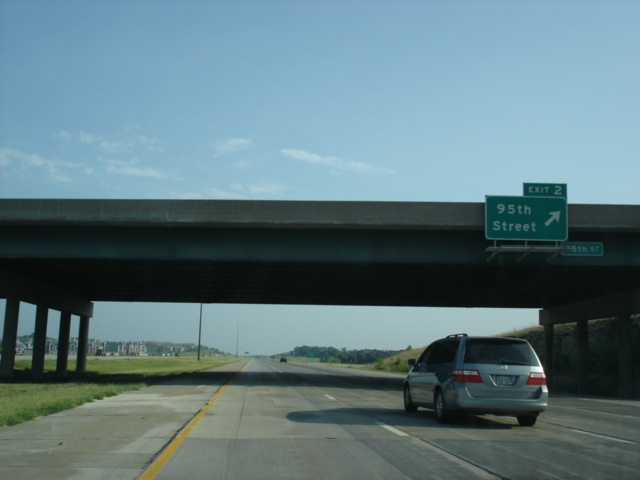 |
Interstate 435 North at Exit 2 - 95th Street. (Photo taken 5/22/05) |
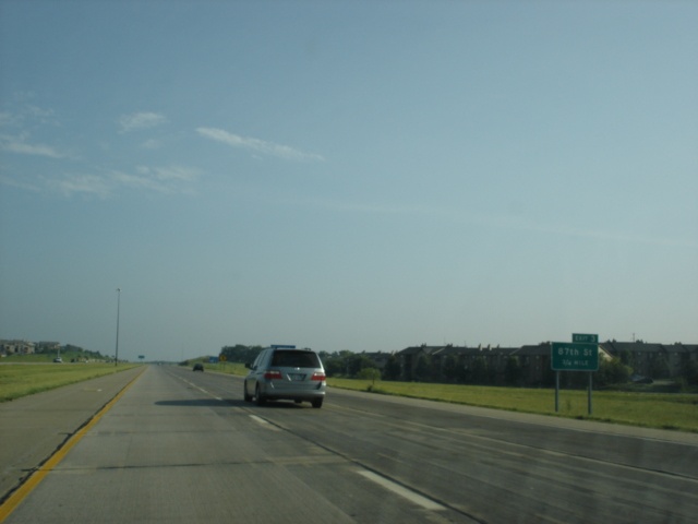 |
Interstate 435 North approaching Exit 3 - 87th Street - 3/4 mile. (Photo taken 5/22/05) |
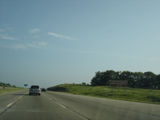 |
Use
Exit 3 to visit the Legler Barn Museum and the Shawnee Mission Park. (Photo taken 5/22/05) |
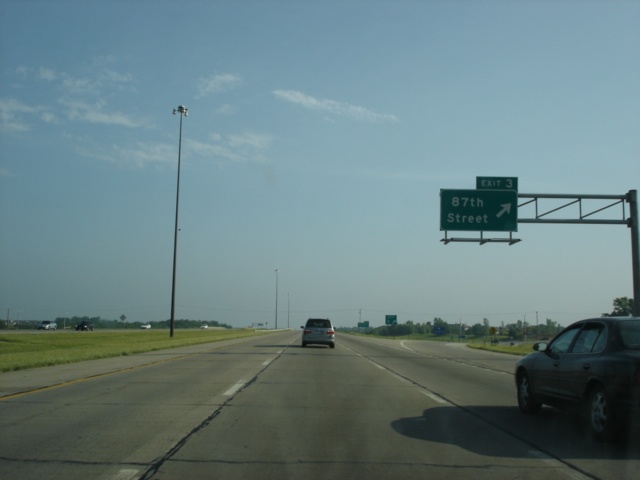 |
Interstate 435 North at Exit 3 - 87th Street. (Photo taken 5/22/05) |
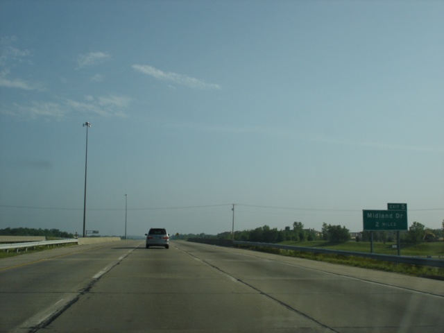 |
Interstate 435 North approaching Exit 5 - Midland Drive - 2 miles. The upcoming exit is near the Shawnee-Lenexa city limit boundary. (Photo taken 5/22/05) |
 |
Mileage sign on Interstate 435 North, one mile south of Midland Drive. (Photo taken 5/22/05) |
 |
Interstate 435 North at Exit 5 - Midland Drive. The interstate has entered the city of Shawnee. (Photo taken 5/22/05) |
 |
Interstate 435 North approaching Exits 6A-B - Shawnee Mission Parkway - 1/2 mile. (Photo taken 5/22/05) |
 |
Mileage sign on Interstate 435 North, 1/8 mile south of Exit 6A (Shawnee Mission Parkway East). (Photo taken 5/22/05) |
 |
Interstate 435 North at Exit 6A - Shawnee Mission Parkway East. (Photo taken 5/22/05) |
 |
Interstate 435 North at Exit 6B - Shawnee Mission Parkway West. (Photo taken 5/22/05) |
 |
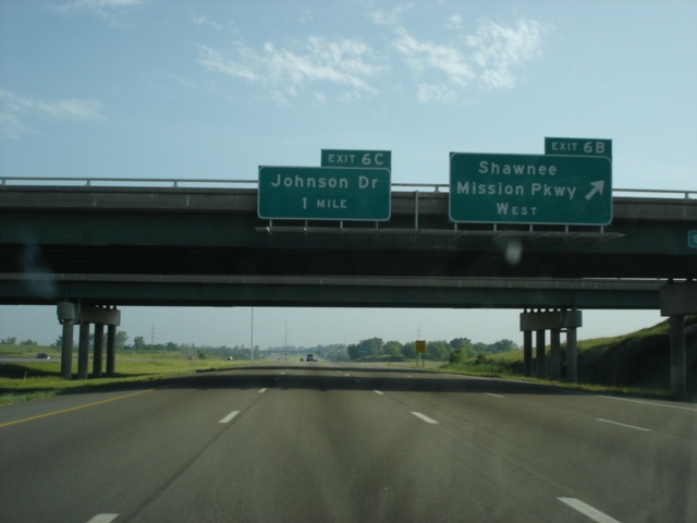
Interstate 435 Kansas assurance shield and the one-half mile advance sign for Exit 6C, Johnson Drive. (Photo taken 5/22/05) |
 |
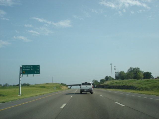
The
next three exits on Interstate 435 North are Johnson Drive (Exit 6C) in 1/2 mile, Holliday Drive (Exit 8A) in 1 1/4 mile, and Woodend Road (Exit 8B) in 2 1/4 miles. (Photo taken 5/22/05) |
 |
Interstate 435 North at Exit 6C - Johnson Drive. The arterial is a major east-west thoroughfare through northern Johnson County. (Photo taken 5/22/05) |
 |
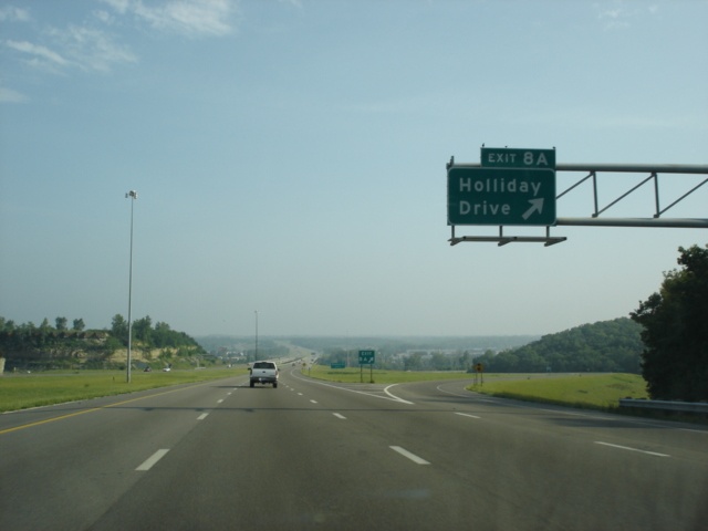
Interstate 435 North approaching Exit 8A - Holliday Drive - 1 mile. Holliday Drive skirts the southern edge of the Kansas River for a few miles and connects 47th Street to Metropolitan Avenue. (Photo taken 5/22/05) |
 |
Use
any of the next nine exits for Kansas City, Kansas. (Photo taken 5/22/05) |
 |
Interstate 435 North approaching Exit 8A - Holliday Drive - 1/2 mile. The overpass in the distance is 53rd Street. (Photo taken 5/22/05) |
 |
Interstate 435 North at Exit 8A - Holliday Drive. (Photo taken 5/22/05) |
 |
Interstate 435 North approaching Exit 8B - Woodend Road - 1 mile. (Photo taken 5/22/05) |
 |
Mileage sign on Interstate 435 North, one-half mile south of Woodend Road. The sign is located on the bridge over the Kansas River. (Photo taken 5/22/05) |
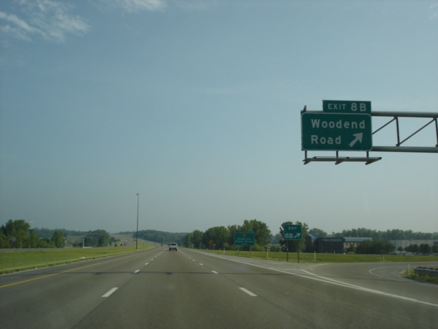 |
Interstate 435 North at Exit 8B - Woodend Road. (Photo taken 5/22/05) |
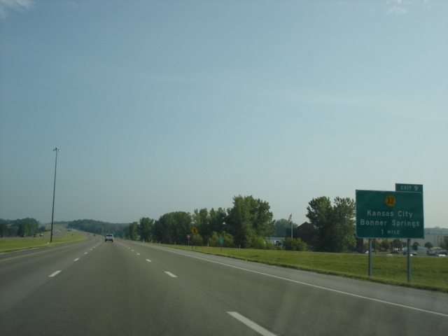 |
Interstate 435 North approaching Exit 9 - Kansas 32 - 1 mile. Kansas 32 is another route between Lawrence and Kansas City. (Photo taken 5/22/05) |
 |
Mileage sign on Interstate 435 North, one-half mile south of Kansas 32. Interstate 70 and the Kansas Turnpike lies three miles ahead. (Photo taken 5/22/05) |
 |
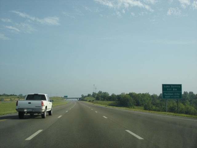
Interstate 435 North at Exit 9 - Kansas 32 - Kansas City/ Bonner Springs. Take Kansas 32 west for one mile to Edwardsville. Bonner Springs is four miles west of Edwardsville. (Photo taken 5/22/05) |
 |
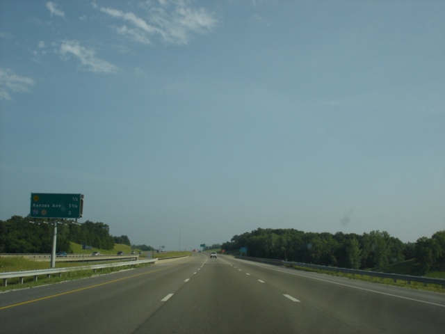
Interstate 435 North approaching Exit 11 - Kansas Avenue - 3/4 mile. (Photo taken 5/22/05) |
 |
Non-standard font prevails on this first advance sign for the upcoming Interstate 70 juncture. (Photo taken 5/22/05) |
 |
Interstate 435 North approaching Exit 11 - Kansas Avenue - 1/4 mile. (Photo taken 5/22/05) |
 |
Interstate 435 North at Exit 11 - Kansas Avenue. (Photo taken 5/22/05) |
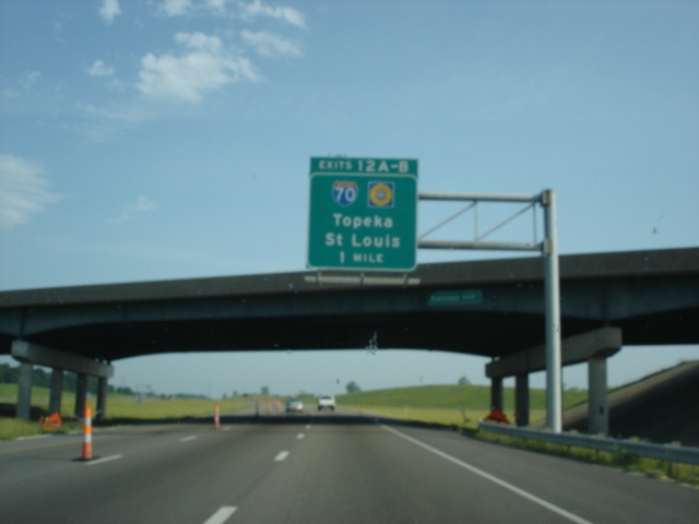 |
Interstate 435 North approaching Exits 12A-B - Interstate 70/ Kansas Turnpike - 1 mile. (Photo taken 5/22/05) |
 |
Use
Interstate 70 West to Exit 410 (110th Street) for the Kansas Tourist Information Center, located near the Kansas Speedway. (Photo taken 5/22/05) |
 |
Mileage sign on Interstate 435 North, one-half mile south of Interstate 70. (Photo taken 5/22/05) |
 |
Interstate 435 North approaching Exit 12A - Interstate 70 East - 1/4 mile. The left lane was closed for pavement rehabilitation. (Photo taken 5/22/05) |
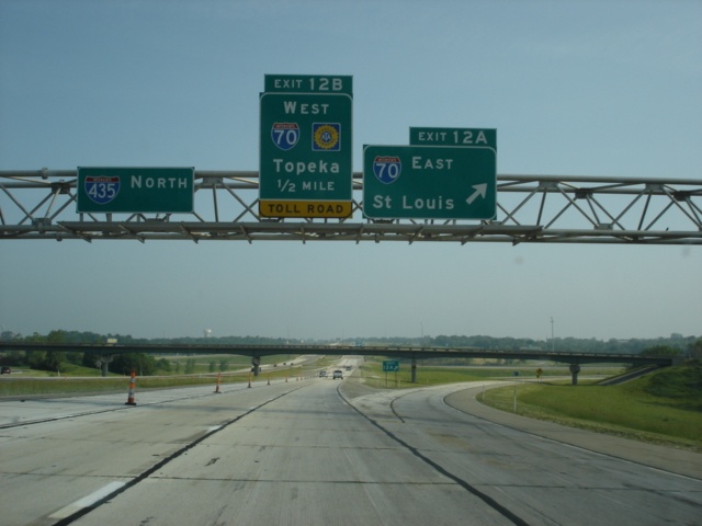 |
Interstate 435 North at Exit 12A - Interstate 70 East - St. Louis. The Gateway to the West is 254 miles to the east. (Photo taken 5/22/05) |
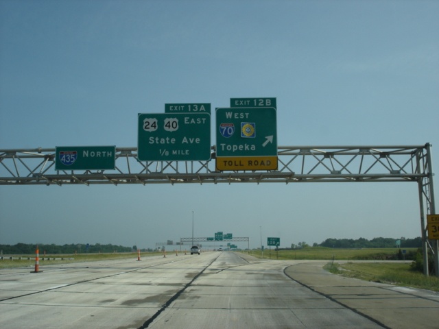 |
Interstate 435 North at Exit 12B - Interstate 70/Kansas Turnpike West - Topeka. The state capital is less than 50 miles from this modified cloverleaf interchange. (Photo taken 5/22/05) |
| Scenes Related to Interstate 435 | |
 |
U.S. 24 East, U.S. 40 East, and U.S. 73 South approaching Interstate 435 near the Kansas Speedway. (Photo taken 5/22/05) |
 |
A
new lane is created for those wanting to leave U.S. 24, U.S. 40, and U.S. 73 for either Interstate 70 or Interstate 435. (Photo taken 5/22/05) |
 |
U.S. 24 East, U.S. 40 East, and U.S. 73 South at Interstate 435 South - TO Interstate 70. Two lanes are allotted for the exit. This interchange also marks the southern terminus of U.S. 73. (Photo taken 5/22/05) |
 |
The
off-ramp from U.S. 24 East, U.S. 40 East, and U.S. 73 South provides three choices. The first option is a ramp to westbound Interstate 70 and the Kansas Turnpike, which departs in one-half mile. Also visible here is an diagrammatical sign for Interstate 435 South at Interstate 70. (Photo taken 5/22/05) |
 |
The
aforementioned three options from the off-ramp. Use the left lane to Interstate 70 East, the center lane to Interstate 435 South, and the right lane to Interstate 70 West. (Photo taken 5/22/05) |
 |
The
right lane departs for Interstate 70 West. The left lane heads for eastbound Interstate 70 in one-quarter mile. (Photo taken 5/22/05) |
 |
Finally, we are about to head onto Interstate 435 South as the ramp to Interstate 70 East leaves. Downtown Kansas City is 15 miles to the east. (Photo taken 5/22/05) |
Page created: August 14, 2005
Last updated:
August 14, 2005