 |
Home Search OKRoads: |
|
|
Home Search OKRoads: |
Interstate 90 Illinois
Eastbound
|
Highway Information |
|
| Miles | 123.89 |
| Counties Traveled Through |
Winnebago, Boone, McHenry, Kane, Cook |
| Cities |
Rockford, Elgin, Chicago |
| Major Junctions |
Interstate 39
Interstate 294 Interstate 190 |
| OKRoads Coverage | |
| Miles Driven by OKRoads (Percentage) |
33 (27%) |
| Western End of Interstate Driven (Section 1) |
Wisconsin State Line |
| Eastern End of Interstate Driven (Section 1) |
Interstate 39 |
| Western End of Interstate Driven (Section 2) |
Interstate 290 |
| Eastern End of Interstate Driven (Section 2) |
Indiana State Line |
Pictures
| Interstate 90 and Interstate 94 East | |
 |
Interstate 90 and Interstate 94 East at Exit 52A - Taylor St./Roosevelt Rd. This is actually on the ramp from Interstate 290 East to Interstate 90 and Interstate 94 East. (Photo taken 5/21/03) |
 |
Interstate 90 and Interstate 94 East approaching Exit 52C - 18th St. - 1/4 mile, and Exit 53 - Interstate 55 - 1/2 mile. (Photo taken 5/21/03) |
 |
Interstate 90 and Interstate 94 East approaching Exit 52C - 1/8 mile, and Exit 53 - 1/4 mile. (Photo taken 5/21/03) |
 |
Interstate 90 and Interstate 94 East at Exit 52C - 18th St. (Photo taken 5/21/03) |
 |
Interstate 90 and Interstate 94 East approaching Exit 53. (Photo taken 5/21/03) |
 |
Interstate 90 and Interstate 94 East at Exit 53 - Interstate 55 - Stevenson Expressway/St. Louis/Lake Shore Dr. (Photo taken 5/21/03) |
 |
First warning that Interstate 90 and Interstate 94 will be splitting into express and local lanes shortly. (Photo taken 5/21/03) |
 |
Interstate 90 and Interstate 94 East c/d lane approaching Interstate 55. (Photo taken 5/21/03) |
 |
Interstate 90 and Interstate 94 East c/d lane at Interstate 55. (Photo taken 5/21/03) |
 |
Interstate 90 and Interstate 94 East approaching the Express/Local lanes. (Photo taken 5/21/03) |
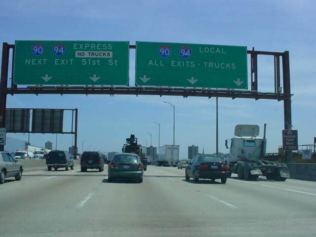 |
Interstate 90 and Interstate 94 East approaching the Express/Local split. The brown sign on the right post of the sign bridge indicates that U.S. Cellular Field can be accessed from the next three exits. (Photo taken 5/21/03) |
 |
After much warning, Interstate 90 and Interstate 94 splits into the Express/Local setup. For some reason, I took the local lanes. I guess I did so I could get better pictures of the exits. (Photo taken 5/21/03) |
 |
Interstate 90 and Interstate 94 East at Exit 54 - 31st St. (Photo taken 5/21/03) |
 |
Interstate 90 and Interstate 94 East at Exit 55A - 35th St. The Skyway is four miles ahead. (Photo taken 5/21/03) |
 |
Interstate 90 and Interstate 94 East at Exit 55B - Pershing Rd. (Photo taken 5/21/03) |
 |
Interstate 90 and Interstate 94 East at Exit 56A - 43rd St. (Photo taken 5/21/03) |
 |
Interstate 90 and Interstate 94 East at Exit 56B - 47th St. (Photo taken 5/21/03) |
 |
Interstate 90 and Interstate 94 East at the Interstate 94 Express exit. (Photo taken 5/21/03) |
 |
Interstate 90 and Interstate 94 East at Exit 57A - 51st St. (Photo taken 5/21/03) |
 |
Interstate 90 and Interstate 94 East at Exit 57B - Garfield Blvd. (Photo taken 5/21/03) |
 |
Interstate 90 and Interstate 94 East at Exit 58A - 59th St. The Skyway is now just one mile ahead. (Photo taken 5/21/03) |
 |
Interstate 90 and Interstate 94 East at Exit 58B - 63rd St. (Photo taken 5/21/03) |
 |
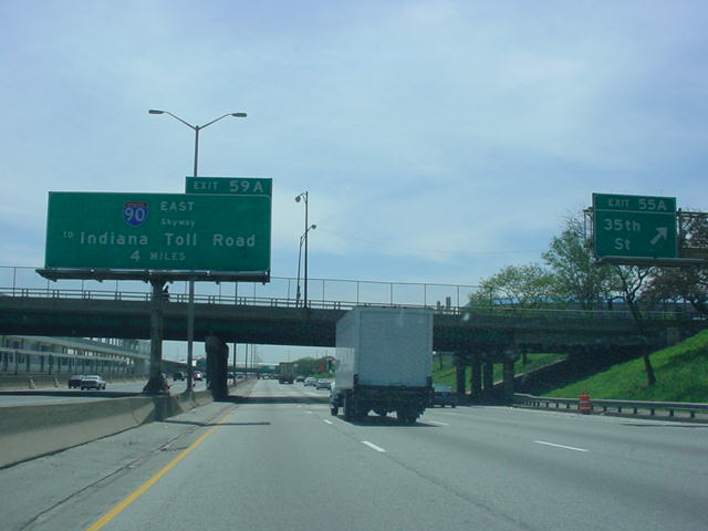
Interstate 90 and Interstate 94 East approaching Exit 59A - Interstate 90 East - Skyway. (Photo taken 5/21/03) |
 |
Interstate 90 and Interstate 94 East at Exit 59A - Interstate 90 East - Skyway/To Indiana Toll Road. (Photo taken 5/21/03) |
| Interstate 90 East | |
 |
Since the Skyway is not Interstate-standard, the highway is signed "TO Interstate 90." Such as seen here just east of Interstate 94. (Photo taken 5/21/03) |
 |
Interstate 90 East approaching Skyway Toll Plaza - 1 mile. Construction was in progress along almost the entire Skyway the day I was there. (Photo taken 5/21/03) |
 |
Interstate 90 East approaching Skyway Toll Plaza - 1/2 mile. (Photo taken 5/21/03) |
 |
"Stop Ahead Pay Toll" sign as the highway approaches the toll plaza. The sign gantries on the Skyway are in this style, much like those found in Colorado, Utah, and Arizona. (Photo taken 5/21/03) |
 |
Chicago Skyway Toll Plaza on "TO" Interstate 90 East. A $2 toll is paid for 2-axle vehicles. (Photo taken 5/21/03) |
 |
The highest point on the Skyway is at the top of this bridge. Moveable barriers were in place on this part of the highway. (Photo taken 5/21/03) |
 |
View from the top of the bridge. Lake Michigan is seen to the left. Otherwise, there isn't much to look at unless you like industrial areas and power lines. (Photo taken 5/21/03) |
 |
The only eastbound exit on the Skyway is at the eastern end for U.S. 12/20/41/Indianapolis Blvd./106th Street. The highway enters the state of Indiana after crossing the federal highways and becomes Interstate 90 once again, without the "TO" banner attached. (Photo taken 5/21/03) |
Page created: February 25, 2006
Last updated:
February 25, 2006