 |
Home Search OKRoads: |
|
|
Home Search OKRoads: |
Interstate 90 Massachusetts
|
Highway Information |
|
| Miles | 135.72 |
| Counties Traveled Through |
Berkshire, Hampden, Worcester, Middlesex, Suffolk |
| Cities |
Springfield, Holyoke, Worcester, Framingham, Boston |
| Major Junctions |
Interstate 91 (Exit 4) Interstate 291 Interstate 84 Interstate 290/ Interstate 495 Interstate 95 Interstate 93 |
| OKRoads Coverage | |
| Miles Driven by OKRoads (Percentage) |
46 (34%) |
| Western End of Interstate Driven |
New York State Line |
| Eastern End of Interstate Driven |
Interstate 91 |
Pictures
| Interstate 90 West | |
 |
Interstate 90 West and MassPike assurance shields as traffic from Interstate 91 and U.S. 5 merges onto the toll road. Interstate 91 crosses the turnpike just ahead. (Photo taken 7/9/05) |
 |
Mileage sign on Interstate 90 West just past Interstate 91. Albany, New York, is 78 miles ahead. (Photo taken 7/9/05) |
 |
A state police station is located one mile ahead, just before the departure of Exit 3. (Photo taken 7/9/05) |
 |
Interstate 90 West approaching Exit 3 - U.S. 202/Massachusetts 10 - 1 mile. U.S. 202 and Massachusetts 10 duplex from the Connecticut state line to a point five miles north of the MassPike. (Photo taken 7/9/05) |
 |
Use U.S. 202 and Massachusetts 10 North to the Westfield-Barnes Airport. The city of Easthampton is 12 miles to the north on Massachusetts 10. (Photo taken 7/9/05) |
 |
Interstate 90 West approaching Exit 3 - U.S. 202/Massachusetts 10 - 1/2 mile. The building on the right is the state police station. (Photo taken 7/9/05) |
 |
Interstate 90 West at Exit 3 - U.S. 202/Massachusetts 10 - Westfield/Northampton. The city of Westfield is home to 40,072 residents and is home to Westfield State College. (Photo taken 7/9/05) |
 |
There are 30 miles between Exit 3 and Exit 2 on the MassPike. Thankfully, they are full of scenic vistas of the Berkshire Mountains, much like this view near the Blandford State Forest. (Photo taken 7/9/05) |
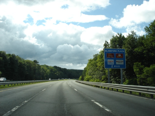 |
Interstate 90 West approaching the Blandford Service Plaza - 2 miles. This is one of six service plazas located throughout the MassPike. (Photo taken 7/9/05) |
 |
Interstate 90 West approaching the Blandford Service Plaza - 1 mile. The final service plaza on the MassPike is 22 miles ahead just after Exit 2 (U.S. 20). (Photo taken 7/9/05) |
 |
Interstate 90 West approaching the Blandford Service Plaza - 1/2 mile. A McDonald's restaurant and Exxon gas station make up the plaza, much like most of the other ones. (Photo taken 7/9/05) |
 |
Interstate 90 West at the Blandford Service Plaza. (Photo taken 7/9/05) |
 |
This scenic view is located at mile marker 22.5 on the MassPike. (Photo taken 7/9/05) |
 |
Not long after mile marker 22.5, Interstate 90 reaches the highest elevation on Interstate 90 east of the Mississippi River at an elevation of 1,724 feet above sea level. The next time Interstate 90 is that high above sea level is not reached until Oacoma, South Dakota, where Interstate 90 reaches 1,729 feet above sea level. That is a long way from western Massachusetts! (Photo taken 7/9/05) |
 |
Mileage sign on Interstate 90 West at about mile marker 20. Lee is nine miles ahead. (Photo taken 7/9/05) |
 |
Here is another scenic view. This appears to be at mile marker 16. (Photo taken 7/9/05) |
 |
Interstate 90 West heads underneath the Appalachian Trail about five miles east of Lee. The foot trail is 2,174 miles long and travels from north Georgia to Maine. (Photo taken 7/9/05) |
 |
Finally we see some signage for Exit 2 for U.S. 20. U.S. 20 meets U.S. 7 four and one-half miles to the northwest of the upcoming interchange. Use U.S. 7 northbound to Pittsfield and take Massachusetts 9 east and Massachusetts 8 north to the town of Adams and the city of North Adams. (Photo taken 7/9/05) |
 |
The town of Lenox is located at the southern end of the U.S. 7/U.S. 20 duplex. Stockbridge and Great Barrington are 6 and 13 miles from Lenox along U.S. 7 southbound, respectively. (Photo taken 7/9/05) |
 |
Interstate 90 West approaching Exit 2 - U.S. 20 - 1 mile. U.S. 20 and Interstate 90 are both cross-country highways and meet many times from Indiana eastward. (Photo taken 7/9/05) |
 |
Use either of the next two exits to Tanglewood, the summer home of the Boston Symphony Orchestra, and the Berkshire Mountains. (Photo taken 7/9/05) |
 |
Use Massachusetts 102 west to Stockbridge and the Norman Rockwell Museum. Head north on U.S. 7 to Williamstown, home of the Sterling and Francine Clark Art Institute. The Massachusetts Museum of Contemporary Art, better known as the Mass MoCA, is located in North Adams. (Photo taken 7/9/05) |
 |
Interstate 90 West approaching Exit 2 - U.S. 20 - 1/2 mile. Pittsfield (pop. 45,793) is 14 miles to the north. (Photo taken 7/9/05) |
 |
Interstate 90 West approaching the Lee Service Plaza - 2 miles. This is the westernmost plaza on the MassPike. (Photo taken 7/9/05) |
 |
Interstate 90 West at Exit 2 - U.S. 20 - Lee/Pittsfield. (Photo taken 7/9/05) |
 |
Interstate 90 West approaching the Lee Service Plaza - 1 mile. (Photo taken 7/9/05) |
 |
Interstate 90 West approaching the Lee Service Plaza - 1/2 mile. The plaza provides the last services on the MassPike. (Photo taken 7/9/05) |
 |
Interstate 90 West at the Lee Service Plaza. (Photo taken 7/9/05) |
 |
Interstate 90 West approaching the western barrier toll plaza - 2 miles. If coming from Springfield, there is no automobile toll charged. To see a blurry picture of the toll ticket, click one of the following links: Front | Back. (Photo taken 7/9/05) |
 |
Exit 1, like Exit 2 before it, can be used to Tanglewood and the Berkshires. (Photo taken 7/9/05) |
 |
Interstate 90 West approaching the western barrier toll plaza - 1 mile. (Photo taken 7/9/05) |
 |
Interstate 90 West approaching Exit 1 - Massachusetts 41 to Massachusetts 102 - 1 mile. Massachusetts 41 travels through southwest Massachusetts, connecting Egremont, Great Barrington, West Stockbridge, and Richmond. (Photo taken 7/9/05) |
 |
Interstate 90 West approaching the western barrier toll plaza - 1/2 mile. (Photo taken 7/9/05) |
 |
Exit 1 departs right after the toll plaza, so stay to the right if you are using Exit 1. The interchange is partial with only a westbound off-ramp and eastbound on-ramp provided. (Photo taken 7/9/05) |
 |
Interstate 90 West at the western barrier toll plaza. The rightmost two lanes are set aside for Citizens Bank Fast Lane users. (Photo taken 7/9/05) |
 |
Interstate 90 West at Exit 1 - Massachusetts 41 to Massachusetts 102 - West Stockbridge. Interstate 90 will enter New York in three miles. Massachusetts 41 meets Massachusetts 102 just to the north of this interchange. (Photo taken 7/9/05) |
 |
Leaving Massachusetts sign as Interstate 90 West leaves the Bay State for the Empire State. We hope to visit the commonwealth again soon. (Photo taken 7/9/05) |
Page created: January 21, 2006
Last updated:
January 22, 2006