 |
Home Search OKRoads: |
|
|
Home Search OKRoads: |
Interstate 10 Texas
Westbound - San
Antonio
|
Highway Information |
|
| Miles | 881.00 |
| Countries Traveled Through |
El Paso, Hudspeth, Culberson, Jeff Davis, Reeves, Pecos, Crockett, Sutton, Kimble, Kerr, Gillespie, Kendall, Bexar, Guadalupe, Gonzales, Fayette, Colorado, Austin, Waller, Fort Bend, Harris, Chambers, Jefferson, Orange |
| Cities | El Paso, Fort Stockton, Kerrville, San Antonio, Houston, Beaumont, Orange |
| Major Junctions | U.S. 54 (Exit 23A) Interstate 20 Interstate 410 Interstate 35 Interstate 35 Interstate 37 Interstate 410 Interstate 610 Interstate 45 U.S. 59 Interstate 610 |
| OKRoads Coverage | |
| Miles Driven by OKRoads (Percentage) |
881 (100%) |
| Western End of Interstate Driven |
New
Mexico State Line |
| Eastern End of Interstate Driven |
Louisiana State Line |
Pictures
Eastbound:
Interstate 410 to Interstate 45
Interstate 45 to Louisiana State Line
Westbound:
Sam Houston Tollway to San Antonio
Fort Stockton to New Mexico State Line
| Westbound | |
 |
Interstate 10 and U.S. 90 enter the city of San Antonio at Exit 591, which serves Farm to Market Road 1518, the overpass that is in the picture. San Antonio, population 1,144,646, is the 8th largest city in the United States, and is home of the San Antonio Spurs NBA basketball team. (Photo taken 3/17/05) |
 |
One rest area is located in Bexar County along Interstate 10, and this is it at Exit 590. (Photo taken 3/17/05) |
 |
Interstate 10 and U.S. 90 West approaching Exit 589 - Pfeil Road/Graytown Road - 3/4 mile. Both roads serve south Schertz. (Photo taken 3/17/05) |
 |
Interstate 10 and U.S. 90 West at Exit 589 - Pfeil Road/Graytown Road. (Photo taken 3/17/05) |
 |
Interstate 10 and U.S. 90 West approaching Exit 587 - Loop 1604/Anderson Loop - 1 mile. Loop 1604 makes up the outer outer beltway of San Antonio. (Interstate 410 is the outer beltway closer to downtown) Loop 1604 is a freeway in northern San Antonio, but otherwise is mostly 2 lanes and travels through rural environs. (Photo taken 3/17/05) |
 |
Interstate 10 and U.S. 90 West approaching Loop 1604 - 1/2 mile. Randolph Air Force Base is located four miles to the north. (Photo taken 3/17/05) |
 |
Interstate 10 and U.S. 90 West at Exit 587 - Loop 1604 - Anderson Loop/Randolph Air Force Base. (Photo taken 3/17/05) |
 |
Interstate 10 and U.S. 90 West approaching Exit 585 - Farm to Market Road 1516 - 1/2 mile. Commercialism begins to line the frontage roads as we approach San Antonio. (Photo taken 3/17/05) |
 |
Interstate 10 and U.S. 90 West at Exit 585 - Farm to Market Road 1516 - Converse. The suburb is home to 11,508 residents. (Photo taken 3/17/05) |
 |
Interstate 10 and U.S. 90 through San Antonio is known as the 90th Infantry Division Memorial Highway. After Interstate 10 and U.S. 90 split at Exit 572, the name continues on U.S. 90 westward to Interstate 410. (Photo taken 3/17/05) |
 |
Interstate 10 and U.S. 90 West approaching Exit 583 - Foster Road - 1 mile. (Photo taken 3/17/05) |
 |
Interstate 10 and U.S. 90 West approaching Exit 583 - Foster Road - 1/4 mile. The arterial serves the suburb of Kirby. (Photo taken 3/17/05) |
 |
Interstate 10 and U.S. 90 West reach Exit 583 - Foster Road. The cloverleaf interchange with Interstate 410 is two miles ahead. (Photo taken 3/17/05) |
 |
Interstate 410 is the through route to take for trucks carrying hazardous materials. (Photo taken 3/17/05) |
 |
Interstate 10 and U.S. 90 West approaching Exit 582 - Ackerman Road/Kirby - Next Right. The speed limit falls to 60 at this interchange for the trip into San Antonio. (Photo taken 3/17/05) |
 |
Interstate 10 and U.S. 90 West at Exit 582 - Ackerman Road/Kirby. Interstate 410 is just 1/2 mile ahead. (Photo taken 3/17/05) |
 |
Interstate 410 is known as the Connally Loop. It is now 1/4 mile away. (Photo taken 3/17/05) |
 |
Interstate 10 and U.S. 90 West at Exit 581 - Interstate 410. The interchange is a full cloverleaf, with collector/distributor lanes facilitating the movements on both interstates. For those staying on Interstate 10, Loop 13 is one mile ahead. (Photo taken 3/17/05) |
 |
The aforementioned collector/distributor lane reaches the departure of Interstate 410 North from the roadway. Interstate 410 North will meet Interstate 35 in three miles. (Photo taken 3/17/05) |
 |
Interstate 10 and U.S. 90 West approaching Exit 580 - Loop 13 - 1/4 mile. El Paso makes an appearance as a control city for the first time. It's only about 560 miles from here, but as we'll see later, there isn't too much of anything between San Antonio and El Paso. (Photo taken 3/17/05) |
 |
Interstate 10 and U.S. 90 West at Exit 580 - Loop 13. The loop, which is actually slightly more than a half of a circle, is known as W.W. White Road through east San Antonio. (Photo taken 3/17/05) |
 |
Use Exit 579 to access the SBC Center, home arena of the Spurs, and the Freeman Coliseum. (Photo taken 3/17/05) |
 |
Interstate 10 and U.S. 90 West approaching Exit 579, Commerce Street and Houston Street, 1/4 mile. (Photo taken 3/17/05) |
 |
Interstate 10 and U.S. 90 West at Exit 579 - Commerce Street/Houston Street. (Photo taken 3/17/05) |
 |
Interstate 10 and U.S. 90 West approaching Exit 578 - M.L. King Jr. Drive/Pecan Valley Drive - 1/2 mile. (Photo taken 3/17/05) |
 |
Interstate 10 and U.S. 90 West at Exit 578 - M.L. King Jr. Drive/Pecan Valley Drive. U.S. 87 will join the interstate in one mile. (Photo taken 3/17/05) |
 |
Interstate 10 and U.S. 90 West approaching Exit 577 - U.S. 87 South - 1/2 mile. U.S. 87 and Interstate 10 have a 54-mile duplex from Exit 577 to Exit 523. (Photo taken 3/17/05) |
 |
Interstate 10 and U.S. 90 West at Exit 577 - U.S. 87 South - Roland Avenue/Victoria. Victoria, population 60,603, is 120 miles from this point. Separate pull-through panels are used for U.S. 90 West and Interstate 10 West/U.S. 87 North as a way of informing motorists that they will be parting ways in five miles. (Photo taken 3/17/05) |
 |
Interstate 10 and U.S. 90 West approaching Exit 576 - Gevers Street/New Braunfels Avenue - 3/4 mile, and Exit 574 - Interstate 37/U.S. 281 - 2 miles. (Photo taken 3/17/05) |
 |
U.S. 87 North joins the freeway as the three federal highways, Interstate 10 West, U.S. 87 North, and U.S. 90 West, approach Exit 576 in 1/4 mile. The variable message sign on the left tells us that the travel time from here to Interstate 35 is under five minutes on this Thursday morning. The travel time to the Cupples Street exit on U.S. 90 is 6-8 minutes. (Photo taken 3/17/05) |
 |
Interstate 10 West, U.S. 87 North, and U.S. 90 West reach Exit 576 for Gevers Street and New Braunfels Avenue. (Photo taken 3/17/05) |
 |
Interstate 10 West, U.S. 87 North, and U.S. 90 West approaching Exit 575 - Pine Street/Hackberry Street - 1/4 mile, and Exit 574 - Interstate 37/U.S. 281 - 1 1/4 miles. (Photo taken 3/17/05) |
 |
A Bud Light truck blocks the sign for the departure of Exit 575 to Pine and Hackberry streets. Three westbound lanes will narrow to two within the Interstate 37 stack interchange, then will widen to four from there to Interstate 35. (Photo taken 3/17/05) |
 |
Interstate 10 West, U.S. 87 North, and U.S. 90 West approaching Exit 574 - Interstate 37/U.S. 281 - 3/4 mile. (Photo taken 3/17/05) |
 |
Use Interstate 37 and U.S. 281 North to get to Downtown San Antonio. Attractions include the Alamo, the Riverwalk, and the Produce Terminal. (Photo taken 3/17/05) |
 |
Interstate 10 West, U.S. 87 North, and U.S. 90 West are almost to Interstate 37 and U.S. 281. The right lane becomes exit only for the interchange. (Photo taken 3/17/05) |
 |
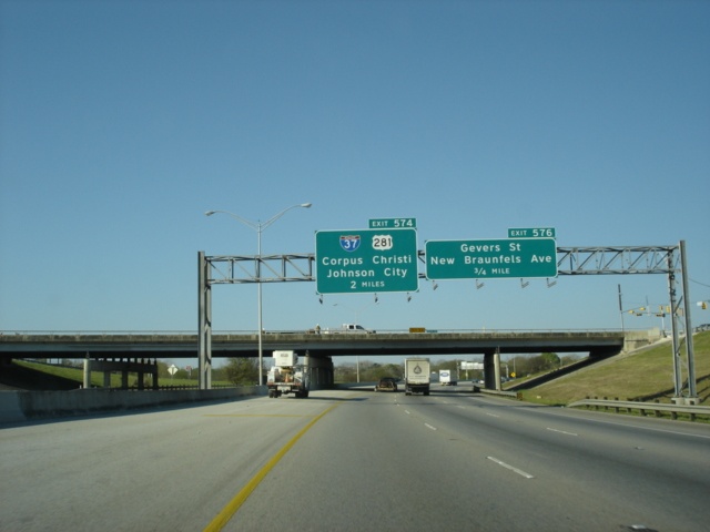
Interstate 10 West, U.S. 87 North, and U.S. 90 West at Exit 574 - Interstate 37/U.S. 281. Corpus Christi is 135 miles to the south, while Johnson City is 61 miles to the north via U.S. 281. (Photo taken 3/17/05) |
 |
The connection between Interstate 10 and Interstate 37 is a stack interchange with Interstate 37 on the top level and Interstate 10 on the bottom level, with the connectors in the middle. (Photo taken 3/17/05) |
 |
The freeway narrows to two lanes through the Interstate 37 stack interchange as the one mile advance signage for Spur 536 appears. Spur 536 connects U.S. 281 at Interstate 410 in south San Antonio to Interstate 35 just west of downtown. (Photo taken 3/17/05) |
 |
Use Probandt Street to connect to Spur 536 from Interstate 10. (Photo taken 3/17/05) |
 |
Interstate 10 West, U.S. 87 North, and U.S. 90 West approaching Exit 572 - Interstate 10 West/U.S. 87 North/Interstate 35 - 1 mile. (Photo taken 3/17/05) |
 |
Interstate 10 West, U.S. 87 North, and U.S. 90 West at Exit 573 - To Spur 536 - Roosevelt Avenue/Probandt Street. The only pull-through panel is for U.S. 90 West, which will take over the mainline in 3/4 mile. (Photo taken 3/17/05) |
 |
All Interstate 10 and U.S. 87 traffic prepares to depart from the right lane. (Photo taken 3/17/05) |
 |
Interstate 10 West, U.S. 87 North, and U.S. 90 West approaching the departure of Interstate 10 West and U.S. 87 North from the mainline. The ramp is signed as Exit 572. Interstate 10 and Interstate 35 share a 2.39 mile duplex. (Photo taken 3/17/05) |
 |
Interstate 10 West and U.S. 87 North depart from U.S. 90 West at Exit 572. U.S. 90 and Interstate 10 will meet one final time at Exit 140A. That interchange in Van Horn marks the western terminus of U.S. 90. (Photo taken 3/17/05) |
 |
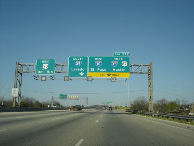
Interstate 10 West and U.S. 87 North at Interstate 35 South - Laredo. The border city is 150 miles to the south. (Photo taken 3/17/05) |
| Interstate 10/Interstate 35 duplex | |
 |
The first exit on the Interstate 10/Interstate 35 duplex is Exit 154A for San Marcos and Nogalitos streets, one-quarter mile. The freeway also prepares to split into upper and lower levels ahead. (Photo taken 3/17/05) |
 |
Interstate 10 West, Interstate 35 North, and U.S. 87 North at Exit 154A - San Marcos and Nogalitos streets. (Photo taken 3/17/05) |
 |
Interstate 35 North/Interstate 10 West approaching the split of the interstates into upper and lower levels. The short double-decker stretch ahead includes Exit 155A for Spur 536 on the lower level. Motorists headed for the Durango Blvd. interchange (Exit 155B) are advised to stay to the right (the upper level). The off-ramp for that particular exit departs the interstates after the end of the double-decker section ahead. (Photo taken 3/17/05) |
 |
One-quarter mile away from the S. Laredo St. and Cevallos St. interchange, the panels for the impending upper and lower level split reflect that Interstate 35 through traffic should take the lower level and Interstate 10 through traffic should take the upper level. Interstate 10 West departs Interstate 35 North in two miles. (Photo taken 3/17/05) |
 |
For those wanting to go to the Produce Terminal Market or to the downtown campus of the University of Texas at San Antonio, Exit 154B is where they should exit. (Photo taken 3/17/05) |
 |
Interstate 35 North/Interstate 10 West at Exit 154B - S. Laredo St./Cevallos St. At this point, the roadway divides into the upper and lower levels. (Photo taken 3/17/05) |
 |
From the upper level of Interstate 35 North and Interstate 10 West, one-half mile south of Durango Blvd. and one mile away from the departure of Interstate 10 West and U.S. 87 North. (Photo taken 3/17/05) |
 |
Interstate 35 North/Interstate 10 West approaching Exit 156 - Second Right. Interstate 10 in northwest San Antonio is named after Robert McDermott, who has been called the Father of the Air Force Academy. As for the roadway, the lower and upper levels reunite at this point. (Photo taken 3/17/05) |
 |
Interstate 35 North/Interstate 10 West at Exit 155B - Durango Blvd./Downtown. (Photo taken 3/17/05) |
 |
Proceeding northward on Interstate 35 (and Interstate 10 West), signs warning of another split into upper and lower levels appear. This split is about 3/4 mile ahead from this point, and about 2 miles away from the northern terminus of Interstate 37. (Photo taken 3/17/05) |
 |
Interstate 35 North/Interstate 10 West approaching Exit 156 - 1/4 mile. (Photo taken 3/17/05) |
 |
Interstate 35 North/Interstate 10 West at Exit 156 - Interstate 10 West/U.S. 87 North - El Paso. (Photo taken 3/17/05) |
| Interstate 10 West | |
 |
A look at the narrow corridor that traffic continuing on Interstate 10 West will see after departing Interstate 35. Interstate 10 will see its own split into upper and lower levels within the next mile. (Photo taken 3/17/05) |
 |
Interstate 10 West and U.S. 87 North approaching its own double-decker section between mile markers 567 and 569. The lower level is the original interstate and has exits to Loop 345, Woodlawn Avenue, and Fredericksburg Road. The upper level was added later and has exits to Spur 421, Culebra Avenue, and Bandera. (Photo taken 3/17/05) |
 |
The lower level also has exits for Colorado Street and Cincinnati Avenue, while the upper level also has exits for Fulton Avenue and Hildebrand Avenue. (Photo taken 3/17/05) |
 |
Interstate 10 West and U.S. 87 North split into upper and lower levels at this point. Colorado Street represents the first exit for the lower level, while Spur 421 does the same for the upper level. (Photo taken 3/17/05) |
 |
Our journey takes us along the lower level. Colorado Street is signed as Exit 569 from Interstate 10. (Photo taken 3/17/05) |
 |
For upper level travelers, Exit 568B for Spur 421 is 1/2 mile ahead. Spur 421 connects Interstate 410 at the Texas 16 North interchange (Exit 13A) with Interstate 10 and U.S. 87. (Photo taken 3/17/05) |
 |
Interstate 10 West and U.S. 87 North at Exit 569 - Colorado Street. (Photo taken 3/17/05) |
 |
Interstate 10 West and U.S. 87 North approaching Exit 568A - Cincinnati Avenue - 1/2 mile. Colorado Street is the cross street in this view. (Photo taken 3/17/05) |
 |
Interstate 10 West and U.S. 87 North lower level approaching Exit 568A - Cincinnati Avenue - Next Right. Spur 421 is the cross street here. (Photo taken 3/17/05) |
 |
Interstate 10 West and U.S. 87 North at Exit 568A - Cincinnati Avenue. The next exit is Exit 567B, Loop 345, 1/4 mile. Loop 345, also known as Fredericksburg Road, is the original alignment of U.S. 87 through northwest San Antonio. (Photo taken 3/17/05) |
 |
Use Exit 567B to access Fulton and Hildebrand avenues from the lower level. The right-of-way is extremely narrow through these parts. (Photo taken 3/17/05) |
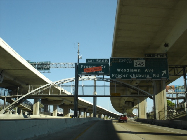 |
Interstate 10 West and U.S. 87 North at Exit 567B for Loop 345, Woodlawn Avenue, and Fredericksburg Road. Exit 566B for Fresno Drive was closed due to ongoing construction that narrowed the interstate from Interstate 410 to Fresno Drive. (Photo taken 3/17/05) |
 |
The two levels of Interstate 10 West and U.S. 87 North prepare to become one again as Exit 566A for Fulton and Hildebrand avenues departs from the upper level. (Photo taken 3/17/05) |
 |
Interstate 10 West and U.S. 87 North approaching Exit 566B - Fresno Drive - 1/2 mile. That is, if the exit were open. (Photo taken 3/17/05) |
 |
Interstate 10 West and U.S. 87 North pull-through panel at what is normally Exit 566B. San Angelo is 211 miles away from this point. (Photo taken 3/17/05) |
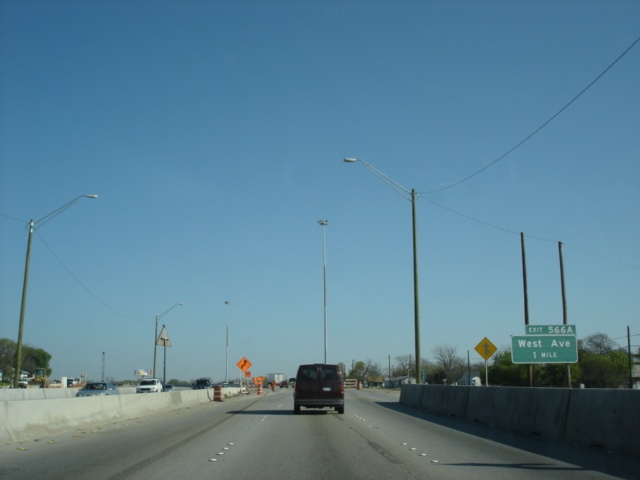 |
Interstate 10 West and U.S. 87 North approaching Exit 566A - West Avenue - 1 mile. Six lanes of traffic were squeezed into the westbound lanes. (Photo taken 3/17/05) |
 |
Interstate 10 West and U.S. 87 North approaching West Avenue, 1/4 mile. (Photo taken 3/17/05) |
 |
Advance signage for Exit 565C (Vance Jackson Road) appears just before the Exit 566A ramp departure. These button copy signs are sure to be meeting the scrap pile once reconstruction is complete. (Photo taken 3/17/05) |
 |
Interstate 10 West and U.S. 87 North at Exit 566A - West Avenue. The arterial connects northwest San Antonio, Castle Hills, and Hill Country Village. (Photo taken 3/17/05) |
 |
The first advance signage for Interstate 410 appears within the West Avenue interchange. The San Antonio beltway is 2 1/4 miles away. (Photo taken 3/17/05) |
 |
Interstate 10 West and U.S. 87 North approaching Exit 565C - Vance Jackson Road - 1/4 mile. (Photo taken 3/17/05) |
 |
Interstate 10 West and U.S. 87 North at Exit 565C - Vance Jackson Road. Exit 565B for First Park Ten Boulevard is located just over Vance Jackson Road. (Photo taken 3/17/05) |
 |
Interstate 10 West and U.S. 87 North approaching Exits 564A-B - Interstate 410 - 3/4 mile. (Photo taken 3/17/05) |
 |
Interstate 10 West and U.S. 87 North enter the city of Balcones Heights as Exit 565A for Crossroads Boulevard appears. Use this exit to access Crossroads Mall. (Photo taken 3/17/05) |
 |
Interstate 10 West and U.S. 87 North approaching Interstate 410/Connally Loop - 1/4 mile. Some of the ramps that will eventually connect Interstate 10 and Interstate 410 are visible. The interchange is in the final stages of a massive reconstruction. (Photo taken 3/17/05) |
 |
Interstate 10 West and U.S. 87 North at Exit 564B - Interstate 410 East. More old button-copy goodies are seen here. This is the final interstate junction on Interstate 10 West until it meets the western terminus of Interstate 20 at Exit 187. (Photo taken 3/17/05) |
 |
As seen from the ramp connecting Interstate 410 East to Interstate 10 West, motorists are advised of the upcoming Exit 561 interchange with Medical Drive and Wurzbach Road, one-half mile ahead. (Photo taken 3/17/05) |
 |
The one-half mile advance signage for Exit 561 from the mainline interstate. Before the Interstate 10/Interstate 410 interchange was reconstructed, an exit for Callaghan Road existed near this location. (Photo taken 3/17/05) |
 |
Drawing within one-quarter mile of Exit 561, Callaghan Road-bound motorists are advised to use the next exit. Callaghan crosses the interstate at this point. (Photo taken 3/17/05) |
 |
Use Exit 561 to get to the South Texas Medical Center and the University of Texas Health Science Center. (Photo taken 3/17/05) |
 |
Interstate 10 West and U.S. 87 North at Exit 561 - Medical Drive/Wurzbach Road. (Photo taken 3/17/05) |
 |
The next interchange is Exit 560 for Ramsgate Drive and Huebner Road. (Photo taken 3/17/05) |
 |
Interstate 10 West and U.S. 87 North at Exit 560 - Ramsgate Drive/Huebner Road. (Photo taken 3/17/05) |
 |
The next two exits are Exit 559 (Woodstone Drive) and Exit 558 (DeZavala Road). (Photo taken 3/17/05) |
 |
Interstate 10 West and U.S. 87 North approaching Exit 559 - Woodstone Drive - 3/4 mile. (Photo taken 3/17/05) |
 |
Now just one-quarter mile from Exit 559, Woodstone Drive is a short connector between Interstate 10 and Vance Jackson Road. (Photo taken 3/17/05) |
 |
Interstate 10 West and U.S. 87 North reach Exit 559 - Woodstone Drive. The next exit is Exit 558, DeZavala Road, 3/4 mile. (Photo taken 3/17/05) |
 |
Interstate 10 West and U.S. 87 North approaching DeZavala Road, 1/4 mile. The right lane becomes exit only for the interchange. The speed limit remains at 65 throughout this stretch. (Photo taken 3/17/05) |
 |
Still approaching DeZavala Road... (Photo taken 3/17/05) |
 |
Interstate 10 West and U.S. 87 North finally reach Exit 558 for DeZavala Road. The arterial serves the community of Shavano Park. (Photo taken 3/17/05) |
 |
The University of Texas at San Antonio takes up 600 acres near the intersection of Interstate 10 and Loop 1604. To use the south entrances, use Exit 557 (Spur 53), and to come in from the north, use Exit 556A (Loop 1604 West). (Photo taken 3/17/05) |
 |
Interstate 10 West and U.S. 87 North approaching Exit 557 - Spur 53/UTSA Boulevard - 1/4 mile. (Photo taken 3/17/05) |
 |
Interstate 10 West and U.S. 87 North at Exit 557 - Spur 53/UTSA Boulevard. The C.W. Anderson Loop is 1 1/4 miles ahead. (Photo taken 3/17/05) |
 |
A slip ramp to the Frontage Road is located between Spur 53 and Loop 1604. The ramp is signed as Exit 556B. (Photo taken 3/17/05) |
 |
Interstate 10 West and U.S. 87 North at Exit 556B - Frontage Road. A Park & Ride lot is located adjacent to this exit. (Photo taken 3/17/05) |
 |
The two outer lanes prepare to depart the interstate for Loop 1604. The Anderson Loop is freeway through northern San Antonio. (Photo taken 3/17/05) |
 |
Interstate 10 West and U.S. 87 North at Exit 556A - Loop 1604/Anderson Loop. (Photo taken 3/17/05) |
 |
The Interstate 10/Loop 1604 interchange in northwest San Antonio is a full cloverleaf, with continuous frontage roads on both sides of both freeways. All cloverleaf connections are made from collector/distributor lanes. This view shows westbound at Loop 1604 East. (Photo taken 3/17/05) |
 |
Yet another Interstate 10 West/U.S. 87 North pull-through panel as the ramp to Loop 1604 West departs. (Photo taken 3/17/05) |
 |
Traffic counts fall somewhat as we depart the Loop 1604 interchange. The next interchange is at LaCantera Parkway in 1/2 mile. Vistas of the scenic Texas hill country become part of the scenery on Interstate 10 for the next several miles as most of the hustle and bustle of the city is behind us. (Photo taken 3/17/05) |
 |
Interstate 10 West and U.S. 87 North prepare to meet Exit 555 - LaCantera Parkway. Six Flags' Fiesta Texas amusement park is located just to the left. (Photo taken 3/17/05) |
 |
Interstate 10 West and U.S. 87 North at Exit 555 - LaCantera Parkway/Fiesta Texas. (Photo taken 3/17/05) |
 |
The next interchange is Exit 554, Camp Bullis Road. Use that exit to get to Raymond Russell Park. (Photo taken 3/17/05) |
 |
Interstate 10 West and U.S. 87 North at Exit 554 - Camp Bullis Road. Camp Bullis is an army range designed to train security police. (Photo taken 3/17/05) |
 |
The signs move from sign bridges to the ground level as Interstate 10 and U.S. 87 prepare to leave San Antonio. The next exit is Exit 551, Boerne Stage Road/Leon Springs, one mile ahead. (Photo taken 3/17/05) |
 |
Interstate 10 West and U.S. 87 North approaching Exit 551 - Boerne Stage Road/Leon Springs - 1/2 mile. We are still officially in the San Antonio city limits, but not for much longer. (Photo taken 3/17/05) |
 |
Interstate 10 West and U.S. 87 North at Exit 551 - Boerne Stage Road/Leon Springs. This particular sign was missing its left half. (Photo taken 3/17/05) |
 |
The final interchange in San Antonio is Exit 550, Farm to Market Road 3351, 3/4 mile. (Photo taken 3/17/05) |
 |
Use Farm to Market Road 3351 to get to the Camp Stanley Military Reservation. (Photo taken 3/17/05) |
 |
Interstate 10 West and U.S. 87 North at Exit 550 - Farm to Market Road 3351/Ralph Fair Road. Farm to Market Road 3351 is 24 miles in length and connects Interstate 10 to Fair Oaks Ranch, Bergheim, and Kendalia, where the highway ends at Farm to Market Road 473. (Photo taken 3/17/05) |
 |
As motorists pass by Exit 550, they are also passing by the end of the San Antonio city limits. Just 490 miles to go until El Paso. (Photo taken 3/17/05) |
Highway Links
Texas:
AARoads.com (Andy Field/Alex Nitzman)
TxDOT Katy Freeway Construction Site
Page created: June 11, 2005
Last updated:
June 16, 2005