 |
Home Search OKRoads: |
|
|
Home Search OKRoads: |
Interstate 40 Tennessee
Eastbound - Lebanon to Interstate 75
South
|
Highway Information |
|
| Miles | 455.28 |
| Counties Traveled Through |
Shelby, Fayette, Haywood, Madison, Henderson, Carroll, Decatur, Benton, Humphreys, Hickman, Dickson, Williamson, Cheatham, Davidson, Wilson, Smith, Putnam, Cumberland, Roane, Loudon, Knox, Sevier, Jefferson, Cocke |
| Cities |
Memphis, Jackson, Nashville, Lebanon, Cookeville, Crossville, Knoxville, Newport |
| Major Junctions |
Interstate 240 (Exit 1E & Exit 12C) Interstate 440 Interstate 65 Interstate 24 Tennessee 840 Interstate 75 Interstate 140 Interstate 640 Interstate 275 Interstate 81 |
| OKRoads Coverage | |
| Miles Driven by OKRoads (Percentage) |
455 (100%) |
| Western End of Interstate Driven |
Arkansas State Line |
| Eastern End of Interstate Driven |
North Carolina State Line |
Pictures
Eastbound:
Lebanon to Interstate 75 South
Interstate 75 South to North Carolina State Line
Westbound:
Jackson to Arkansas State Line
| Interstate 40 East | |
 |
Interstate 40 East approaching Exit 245 - Linwood Road - 1 mile. The road connects U.S. 70 at Cherry Valley to Interstate 40. (Photo taken 7/5/05) |
 |
Interstate 40 East at Exit 245 - Linwood Road. (Photo taken 7/5/05) |
 |
Interstate 40 East approaching a parking area in eastern Wilson County. The parking area also includes a truck station, but both were closed at the time of this photograph. (Photo taken 7/5/05) |
 |
Interstate 40 East at the Wilson County parking area and truck station. (Photo taken 7/5/05) |
 |
Interstate 40 East approaching Exit 254 - Tennessee Secondary 141 - 1 1/2 miles. The secondary route parallels Interstate 40 from Lebanon to Silver Point, a distance of about 40 miles. (Photo taken 7/5/05) |
 |
Interstate 40 East at Exit 254 - Tennessee Secondary 141 - Alexandria. The city of 814 residents is seven miles to the south via Tennessee 53, which intersects the secondary highway just south of the interstate. (Photo taken 7/5/05) |
 |
The next exit serves Tennessee 53. The dam forms a lake of the same name and is nine miles to the north. (Photo taken 7/5/05) |
 |
Interstate 40 East approaching Exit 258 - Tennessee 53 - 1 mile. Carthage, the seat of Smith County, is five miles north of Interstate 40. (Photo taken 7/5/05) |
 |
Interstate 40 East at Exit 258 - Tennessee 53 - Carthage/Gordonsville. The state highway spans most of the vertical length of the state, beginning at U.S. 41 near Manchester and ending at the Kentucky state line. Two sections of the state highway are secondary routes. (Photo taken 7/5/05) |
 |
Interstate 40 East approaching the Smith County rest area - 1 mile. A tourist information center is also located at the rest area. (Photo taken 7/5/05) |
 |
Interstate 40 East at the Smith County rest area and tourist information center. The next rest area is 58 miles ahead just past Crossville. This rest area is located just west of the Caney Fork River, which also makes up the Smith-Putnam county line. (Photo taken 7/5/05) |
 |
Interstate 40 East approaching Exit 268 - Tennessee Secondary 96/Buffalo Valley Road - 3/4 mile. We begin to ascend a bit as we enter the foothills of the Appalachians. (Photo taken 7/5/05) |
 |
Edgar Evins State Park is located on Center Hill Lake, five miles to the south. (Photo taken 7/5/05) |
 |
Interstate 40 East at Exit 268 - Tennessee 96/Buffalo Valley Road - Center Hill Dam. (Photo taken 7/5/05) |
 |
The setting sun and the rolling landscape played some tricks with the next few pictures. The sign pictured here is the one mile advance signage for Exit 273, Tennessee 56 South. (Photo taken 7/5/05) |
 |
Use Tennessee 56 South to the Joe L. Evins Appalachian Center for Craft, a satellite campus of Tennessee Tech University. The craft college is located near Smithville. (Photo taken 7/5/05) |
 |
Interstate 40 East at Exit 273 - Tennessee 56 South - Smithville/McMinnville. Both cities are seats of their respective counties (De Kalb and Warren). McMinnville is 32 miles to the south and is located at the intersection of U.S. 70, Tennessee 55, and Tennessee 56. (Photo taken 7/5/05) |
| Interstate 40 East and Tennessee 56 North | |
 |
Interstate 40 East and Tennessee 56 North approaching Exit 276 - Old Baxter Road - 1 mile. The road appears to be a pre-interstate routing of Tennessee 56. (Photo taken 7/5/05) |
 |
Interstate 40 East and Tennessee 56 North at Exit 276 - Old Baxter Road. (Photo taken 7/5/05) |
 |
Interstate 40 East and Tennessee 56 North approaching Exit 280 - Tennessee 56 North - 1 mile. Gainesboro, one of just three cities in Jackson County, is 16 miles north of Interstate 40. (Photo taken 7/5/05) |
 |
Dale Hollow Dam is located on the lake of the same name just east of Celina, near the Kentucky state line. Use Tennessee 56 North to Tennessee 53 North to the lake. (Photo taken 7/5/05) |
 |
Camp Discovery, a camp for those who are physcially challenged, is located west of Gainesboro. (Photo taken 7/5/05) |
 |
Interstate 40 East and Tennessee 56 North at Exit 280 - Tennessee 56 North - Baxter/Gainesboro. (Photo taken 7/5/05) |
| Interstate 40 East | |
 |
The next four exits serve the city of Cookeville. With a population of 26,052, it is the largest city on Interstate 40 between Nashville and Knoxville. The first Cookeville exit is Exit 286, Tennessee Secondary 135/South Willow Avenue, one mile. (Photo taken 7/5/05) |
 |
Cookeville is the home of Tennessee Technological University, a public institution with over 9,000 students. (Photo taken 7/5/05) |
 |
Interstate 40 East at Exit 286 - Tennessee Secondary 135/South Willow Avenue. The secondary route connects Sparta, Cookeville, and Gainesboro. (Photo taken 7/5/05) |
 |
The headquarters for District Six of the Tennessee Highway Patrol is located in Cookeville. Use Exit 287 (Tennessee Secondary 136) to the headquarters. (Photo taken 7/5/05) |
 |
Interstate 40 East approaching unmarked Exit 287 - Tennessee Secondary 136 - 1/4 mile. Use Tennessee Secondary 136 south as a shortcut to Tennessee 111 south to Sparta. (Photo taken 7/5/05) |
 |
Exit 288 serves Tennessee 111. Take the state highway south to U.S. 70S to Rock Island State Park, located southwest of Sparta. Or, use Tennessee Secondary 136 as a shortcut to Tennessee 111, then continue on Tennessee Secondary 136 south after a short duplex. (Photo taken 7/5/05) |
 |
Interstate 40 East at Exit 287 - Tennessee Secondary 136 - Cookeville/Sparta. (Photo taken 7/5/05) |
 |
Fall Creek Falls State Park is east of Spencer. To get to the park, take Tennessee 111 South to Tennessee 30 East to Tennessee Secondary 284 West. (Photo taken 7/5/05) |
 |
Interstate 40 East approaching Exit 288 - Tennessee 111 - 3/4 mile. Much of the state highway between Cookeville and Sparta is freeway. However, the connection here is a simple diamond interchange favoring Interstate 40. (Photo taken 7/5/05) |
 |
Use Tennessee 111 North to Algood, a northern suburb of Cookeville. (Photo taken 7/5/05) |
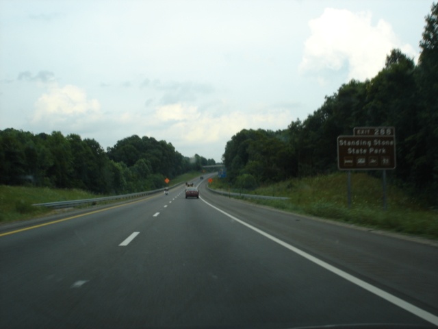 |
Standing Stone State Park is west of Livingston. The park covers nearly 11,000 acres on the Cumberland plateau. (Photo taken 7/5/05) |
 |
Interstate 40 East at Exit 288 - Tennessee 111 - Livingston/Sparta. The seats of Overton and White counties are 20 miles north and 15 miles south of Interstate 40, respectively. Tennessee 111 South eventually connects to U.S. 27, which leads directly into Chattanooga, 92 miles to the south. (Photo taken 7/5/05) |
 |
Interstate 40 East approaching Exit 290 - U.S. 70N - 1 mile. Between Lebanon and Crossville, U.S. 70 is split into two routes. The other route is simply signed as U.S. 70 and stays to the south of Interstate 40, while U.S. 70N stays north of the interstate for the most part. (Photo taken 7/5/05) |
 |
Interstate 40 East at Exit 290 - U.S. 70N - Cookeville. This is the final Cookeville exit. (Photo taken 7/5/05) |
 |
Just east of Cookeville, the interstate crosses the Falling Water River. This scenic view is afforded while crossing the river. (Photo taken 7/5/05) |
 |
Interstate 40 continues to ascend as truckers are advised to use the right lane between Cookeville and Monterey. (Photo taken 7/5/05) |
 |
The speed limit falls to 65 for the uphill grade. (Photo taken 7/5/05) |
 |
There is also falling rock to be aware of for the next four miles. (Photo taken 7/5/05) |
 |
The view of Interstate 40 eastbound at mile marker 293. (Photo taken 7/5/05) |
 |
The view of Interstate 40 eastbound at mile marker 294. Poplar Grove Road travels over the interstate in this view. (Photo taken 7/5/05) |
 |
The next two exits both serve U.S. 70N and the city of Monterey. Both interchanges are less than one mile apart. Use Exit 300 to Pickett State Park and the Big South Fork National Recreation Area. Both are located on the Tennessee-Kentucky border. (Photo taken 7/5/05) |
 |
Interstate 40 East approaching Exit 300 - U.S. 70N/Tennessee 84 - 1 mile. The state highway shares a two-mile duplex with U.S. 70N. (Photo taken 7/5/05) |
 |
Interstate 40 East at Exit 300 - U.S. 70N/Tennessee 84 - Monterey/Livingston. Not to be confused with Monterey, California, Monterey, Tennessee, is home to 2,717 residents. (Photo taken 7/5/05) |
 |
Interstate 40 East approaching Exit 301 - U.S. 70N - 1/2 mile. To the left, U.S. 70N travels through Monterey, and will exit the city just ahead. (Photo taken 7/5/05) |
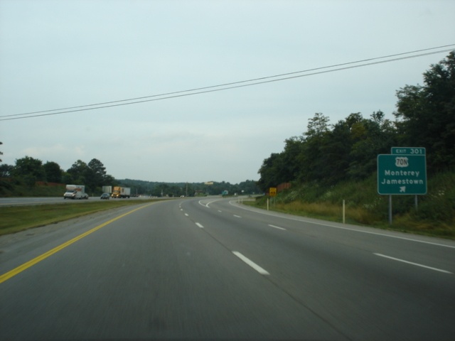 |
Interstate 40 East at Exit 301 - U.S. 70N - Monterey/Jamestown. Take U.S. 70N West, Tennessee 84 North, Tennessee 62 East, and U.S. 127 North to Jamestown, located at the intersection of U.S. 127 and Tennessee 52. (Photo taken 7/5/05) |
 |
Mileage sign on Interstate 40 East just past Monterey. Crossville is 17 miles ahead, while Knoxville is 81 miles away. (Photo taken 7/5/05) |
 |
Interstate 40 East approaching Exit 311 - Plateau Road - 1 mile. Plateau Road connects U.S. 70N to U.S. 127 and can be used as an alternate route to U.S. 127 North from Interstate 40 or U.S. 70N. (Photo taken 7/5/05) |
 |
Interstate 40 East at Exit 311 - Plateau Road. (Photo taken 7/5/05) |
 |
The next three exits serve the city of Crossville, population 9,603, and the seat of Cumberland County. It is the last city we will see on Interstate 40 eastbound within the Central Time Zone. Exit 317, the first Crossville exit, serves U.S. 127. Use U.S. 127 southbound to Cumberland Mountain State Park, the site of a "Bear Trace" golf course designed by golfing legend Jack Nicklaus. (Photo taken 7/5/05) |

|
Use U.S. 127 north to the aforementioned Pickett State Park and the Big South Fork National Recreation Area. (Photos taken 7/5/05) |
 |
Interstate 40 East approaching Exit 317 - U.S. 127 - 1 mile. Just ahead, a resurfacing project temporarily narrowed eastbound traffic to one lane through Crossville. (Photo taken 7/5/05) |
 |
Pikeville, the seat of Bledsoe County, is 32 miles south of Crossville via U.S. 127. (Photo taken 7/5/05) |
 |
The Cumberland County Playhouse, a family theater, is located in Crossville. (Photo taken 7/5/05) |
 |
Interstate 40 East at Exit 317 - U.S. 127 - Crossville/Jamestown. A 32 mile drive on U.S. 127 north lies between Crossville and Jamestown. (Photo taken 7/5/05) |
 |
Interstate 40 East approaching Exit 320 - Tennessee Secondary 298/Genesis Road - 1 mile. The secondary route connects Crossville to Tennessee 62 west of Lancing. (Photo taken 7/5/05) |
 |
Interstate 40 East at Exit 320 - Tennessee Secondary 298/Genesis Road. (Photo taken 7/5/05) |
 |
Interstate 40 East approaching Exit 322 - Tennessee Secondary 101/Peavine Road - 1 mile. Tennessee Secondary 101 begins at Tennessee 30 in Mount Crest and travels northeast to Fairfield Glade, where the highway ends without intersecting another highway. (Photo taken 7/5/05) |
 |
Fairfield Glade Resort, the golf capital of Tennessee, is located on Tennessee Secondary 101 eight miles northeast of Crossville. (Photo taken 7/5/05) |
 |
Interstate 40 East at Exit 322 - Tennessee Secondary 101/Peavine Road. (Photo taken 7/5/05) |

|
Crossville is off to the right on Tennessee Secondary 101. Turn left to the Fairfield Glade Resort. (Photos taken 7/5/05) |
 |
Interstate 40 East approaching the Cumberland County rest area - 1 mile. A tourist information center is also located here. (Photo taken 7/6/05) |
 |
Interstate 40 East at the Cumberland County rest area and tourist information center. Conditions were a bit foggy on this early July morning. (Photo taken 7/6/05) |
 |
Interstate 40 East approaching Exit 329 - U.S. 70 - 1 mile. The exit does not serve U.S. 70 directly, rather, motorists must take a short trip on a side road to the federal highway. (Photo taken 7/6/05) |
 |
The Justin P. Wilson Cumberland Trail State Park is a 165-mile long walking trail along the Cumberland Mountains, with plans to add more than 100 miles to the trail. The trail currently extends from just west of Chattanooga to Cumberland Gap, located at the Kentucky-Tennessee-Virginia border. (Photo taken 7/6/05) |
 |
Interstate 40 East at Exit 329 - U.S. 70 - Crab Orchard. (Photo taken 7/6/05) |
 |
Motorists are given this view on Interstate 40 East near mile marker 330. (Photo taken 7/6/05) |
 |
A parking area for trucks only is located in eastern Cumberland County. (Photo taken 7/6/05) |
 |
Interstate 40 East at the Cumberland County parking area. (Photo taken 7/6/05) |
 |
Interstate 40 East approaching Exit 338 - Tennessee Secondary 299 South - 1 mile. The route connects U.S. 70 in Wester to Tennessee Secondary 328 in Oakdale. (Photo taken 7/6/05) |
 |
Interstate 40 East at Exit 338 - Tennessee Secondary 299 South - Westel Road/Rockwood. Interstate 40 parallels the secondary highway for two miles. (Photo taken 7/6/05) |
 |
Interstate 40 East approaching Exit 340 - Tennessee Secondary 299 North - 3/4 mile. This is the final exit in the Central Time Zone, as the Airport Road overpass marks the Cumberland-Roane county line and the beginning of the Eastern Time Zone. (Photo taken 7/6/05) |
 |
A 6% grade is present for the next two miles, as this blurry picture indicates. (Photo taken 7/6/05) |
 |
Interstate 40 East at Exit 340 - Tennessee Secondary 299 North/Airport Road. (Photo taken 7/6/05) |
 |
Interstate 40 East as it enters Roane County and the Eastern Time Zone. (Photo taken 7/6/05) |

|
Views of Interstate 40 east at mile markers 341 and 342. The truckers speed limit is set at 50 mph for the uphill climb. (Photos taken 7/6/05) |
 |
Interstate 40 East approaching Exit 347 - U.S. 27 - 1 mile. U.S. 27 closely parallels the Tennessee River for most of its distance in the state south of Interstate 40. (Photo taken 7/6/05) |
 |
For the third time, the Big South Fork National Recreation Area is mentioned on a brown guide sign. The area is actually located closer to U.S. 27 than either of the other two highways that it was mentioned at previously. (Photo taken 7/6/05) |
 |
Use U.S. 27 north and Tennessee 52 west to historic Rugby, home of Victorian England-style structures. (Photo taken 7/6/05) |
 |
Use Exit 347 to Roane State Community College, Watts Bar Lake, and the Obed Wild and Scenic River. (Photo taken 7/6/05) |
 |
Use U.S. 27 North, Tennessee 62 East, and Tennessee Secondary 116 North to one of our favorite named state parks in the country, the Frozen Head State Park. (Photo taken 7/6/05) |
 |
Interstate 40 East finally reaches Exit 347 - U.S. 27 - Harriman/Rockwood. It is difficult to tell from here, but Harriman does have all travelers' services. (Photo taken 7/6/05) |
 |
Interstate 40 East approaching Exit 350 - Tennessee Secondary 29 - 3/4 mile. Route 29 is one of the shortest secondary routes in the state at a length of just 2.4 miles from U.S. 70 to U.S. 27 in Harriman. (Photo taken 7/6/05) |
 |
Interstate 40 East at Exit 350 - Tennessee Secondary 29 - Midtown, a community located on U.S. 70. (Photo taken 7/6/05) |
 |
Interstate 40 East approaching Exit 352 - Tennessee 58 South - 1 mile. Kingston (pop. 5,264) is the seat of Roane County. (Photo taken 7/6/05) |
 |
Interstate 40 East at Exit 352 - Tennessee 58 South - Kingston. Heading southbound, Tennessee 58 does not end until it reaches Tennessee 153 in Chattanooga. (Photo taken 7/6/05) |
| Interstate 40 East and Tennessee 58 North | |
 |
Interstate 40 East and Tennessee 58 North assurance shields on their short four-mile duplex. (Photo taken 7/6/05) |
 |
Blurry view of a mileage sign on Interstate 40 East and Tennessee 58 North. Oak Ridge is 18 miles away via Tennessee 58 and Tennessee 95 north, while Knoxville is 35 miles ahead. (Photo taken 7/6/05) |
 |
Interstate 40 East and Tennessee 58 North approaching Exit 355 - Lawnville Road - 1 mile. Lawnville Road, like most roads in this area, travels in a diagonal fashion from southwest to northeast, and connects U.S. 70 to Lawnville and Century Acres. (Photo taken 7/6/05) |
 |
Interstate 40 East and Tennessee 58 North at Exit 355 - Lawnville Road. (Photo taken 7/6/05) |
 |
Interstate 40 East and Tennessee 58 North approaching Exit 356 - Tennessee 58 North - 1 mile, as Lawnville Road prepares to cross over the interstate. (Photo taken 7/6/05) |
 |
Interstate 40 East and Tennessee 58 North at Exit 356 - Tennessee 58 North - Oak Ridge/Gallaher Road. Tennessee 58 ends seven miles to the northeast at Tennessee 95. (Photo taken 7/6/05) |
| Interstate 40 East | |
 |
Interstate 40 East approaching Exit 360 - Buttermilk Road - 1 mile. Buttermilk Road parallels Interstate 40 between mile markers 359 and 367. (Photo taken 7/6/05) |
 |
Interstate 40 East at Exit 360 - Buttermilk Road. (Photo taken 7/6/05) |
 |
Interstate 40 East approaching the Roane County trucks-only parking area, 3/4 mile. (Photo taken 7/6/05) |
 |
Interstate 40 East at the Roane County parking area. (Photo taken 7/6/05) |
 |
Interstate 40 East approaching Exit 364 - U.S. 321/Tennessee 95 - 1 mile. The upcoming interchange marks the northern terminus of U.S. 321, even though it has been running east-west since Boone, North Carolina. Some argue that this is the second southern terminus of U.S. 321 and there is no northern terminus. But I digress... (Photo taken 7/6/05) |
 |
Use Tennessee 95 North to Melton Hill Dam and U.S. 321 North (south) to the Great Smoky Mountains National Park, the most visited national park in the nation. (Photo taken 7/6/05) |
 |
Interstate 40 East at Exit 364 - U.S. 321/Tennessee 95 - Lenoir City/Oak Ridge. The cities mentioned on the sign are 13 miles north and seven miles southeast, respectively. (Photo taken 7/6/05) |
 |
Interstate 40 East approaching Exit 368 - Interstate 75 - 1 mile. This marks the western end of a heavily-traveled duplex of two major interstates. (Photo taken 7/6/05) |
 |
Interstate 40 East approaching Exit 368 - Interstate 75 South - 1/2 mile. (Photo taken 7/6/05) |
 |
Interstate 40 East at Exit 368 - Interstate 75 South - Chattanooga. The choo-choo city is 84 miles to the southwest, and downtown Atlanta, Georgia, is 191 miles south of this interchange. (Photo taken 7/6/05) |
 |
Interstate 40 East makes up the bottom level of the tri-level interchange. The top level carries Interstate 75 southbound, while the middle level is for traffic going from Interstate 75 north to Interstate 40 west. The capacity of the freeway is about to double as we suddenly enter the suburban sprawl of the Knoxville area. (Photo taken 7/6/05) |
| Scenes Related to Interstate 40 | |
 |
Tennessee Secondary 101 North at Interstate 40 West - Nashville. Downtown Music City is 112 miles to the west. (Photo taken 7/5/05) |
 |
Tennessee Secondary 101 South approaching Interstate 40. This sign directing eastbound interstate traffic to continue straight is located before the on-ramp to Interstate 40 West. (Photo taken 7/6/05) |
 |
Tennessee Secondary 101 South at Interstate 40 West, as we can barely see here. But, hey, it was just after 6 am. The sunrise at this time of the year in Crossville is at 5:30 am, due to its location in relation to the time zone boundary, which is just 18 miles to the east. (Photo taken 7/6/05) |
 |
Tennessee Secondary 101 South approaching Interstate 40 East as we prepare to cross the interstate. (Photo taken 7/6/05) |
 |
Tennessee Secondary 101 South at Interstate 40 East - Knoxville. The seat of Knox County is 65 miles to the left. Continue straight ahead into downtown Crossville. (Photo taken 7/6/05) |
Page created: October 27, 2005
Last updated:
October 29, 2005


