 |
Home Search OKRoads: |
|
|
Home Search OKRoads: |
Interstate 90 Minnesota
Westbound - Wisconsin State Line to U.S.
63
|
Highway Information |
|
| Miles | 275.70 |
| Counties Traveled Through |
Rock, Nobles, Jackson, Martin, Faribault, Freeborn, Mower, Olmsted, Winona |
| Cities |
Worthington, Fairmont, Albert Lea, Austin, Rochester |
| Major Junctions |
Interstate 35 (Exits 159A-B) |
| OKRoads Coverage | |
| Miles Driven by OKRoads (Percentage) |
276 (100%) |
| Western End of Interstate Driven |
South Dakota State Line |
| Eastern End of Interstate Driven |
Wisconsin State Line |
Pictures
Westbound:
Wisconsin State Line to U.S. 63
U.S. 71 to South Dakota State Line
| Interstate 90 West | |
 |
Welcome to Minnesota sign as Interstate 90 finishes crossing the Mississippi River. The typical Minnesota Welcomes You sign is set in the trees on the hillside in the distance. (Photo taken 7/12/05) |
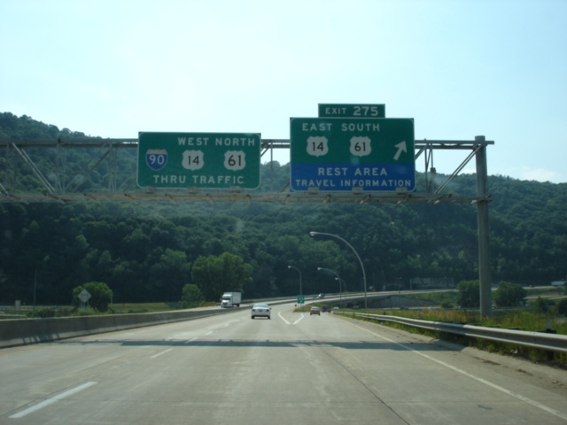 |
Interstate 90 West at Exit 275 - U.S. 14 East/U.S. 61 South. The Minnesota welcome center is located at this interchange. (Photo taken 7/12/05) |
 |
View of the Exit 275 off-ramp to U.S. 14 and U.S. 61. La Crescent (pop. 4,923) is two miles to the south. (Photo taken 7/12/05) |
 |
This picture shows the view after making a right turn at the end of the off-ramp. The off-ramp is to the right. (Photo taken 7/12/05) |
| Interstate 90 and U.S. 14 West and U.S. 61 North | |
 |
Interstate 90 and U.S. 14 West and U.S. 61 North approaching Exit 272B-A - Dresbach - 1 mile. Standard exit numbering practices in Minnesota indicate that when there are two off-ramps to separate roads in a one-mile span in one direction (ie. Exit 272A and Exit 272B serve different roads), and there is just one exit in the other direction at that mile, such as the case here, the one ramp gets both suffixes. In other words, Exit 272B-A in the westbound direction is just one ramp. (Photo taken 7/12/05) |
 |
Interstate 90 and U.S. 14 West and U.S. 61 North at Exit 272B-A - Dresbach. (Photo taken 7/12/05) |
 |
Interstate 90 and U.S. 14 West and U.S. 61 North approaching Exit 269 - U.S. 14 West/U.S. 61 North - 2 miles. (Photo taken 7/12/05) |
 |
Interstate 90 and U.S. 14 West and U.S. 61 North assurance shields near mile marker 271. (Photo taken 7/12/05) |
 |
Interstate 90 and U.S. 14 West and U.S. 61 North approaching Exit 270 - Dakota - 3/4 mile. Dakota is home to 329 people. (Photo taken 7/12/05) |
 |
Interstate 90 and U.S. 14 West and U.S. 61 North at Exit 270 - Dakota. (Photo taken 7/12/05) |
 |
The U-Haul trailer partially blocks this sign that indicates that motorists should use Interstate 90 to Rochester and Austin. (Photo taken 7/12/05) |
 |
Interstate 90 and U.S. 14 West and U.S. 61 North approaching Exit 269 - U.S. 14 West/U.S. 61 North - 1/4 mile. (Photo taken 7/12/05) |
 |
Interstate 90 and U.S. 14 West and U.S. 61 North at Exit 269 - U.S. 14 West/U.S. 61 North - Winona. The seat of Winona County, the city of Winona is home to 27,069 residents and is 17 miles to the northwest. (Photo taken 7/12/05) |
| Interstate 90 West | |
 |
Mileage sign on Interstate 90 West just past Exit 269. The next exit is Winona County 12 in three miles. Albert Lea is 109 miles ahead, and the Rochester exit (U.S. 52) is 51 miles ahead. (Photo taken 7/12/05) |
 |
Interstate 90 West approaching Exit 266 - Winona County 12 - 1 mile. Winona County 12 travels parallel to Interstate 90's westbound lanes from Exit 266 to around mile marker 246. (Photo taken 7/12/05) |
 |
The Great River Bluffs State Park is located just north of the interstate. (Photo taken 7/12/05) |
 |
Interstate 90 West at Exit 266 - Winona County 12 - Nodine. Nodine is 1.5 miles to the south. (Photo taken 7/12/05) |
 |
Interstate 90 West approaching Exit 257 - Minnesota 76 - 2 miles. Minnesota 76 begins at this interchange and travels south to the Iowa state line, a distance of 36.7 miles. (Photo taken 7/12/05) |
 |
Interstate 90 West approaching Exit 257 - Minnesota 76 - 1 mile. Houston (pop. 1,020) is 14 miles to the south. (Photo taken 7/12/05) |
 |
Use County 12 West to Witoka. Head east on County 12 to Ridgeway. (Photo taken 7/12/05) |
 |
Interstate 90 West at Exit 257 - Minnesota 76 - Houston. (Photo taken 7/12/05) |
 |
Interstate 90 West approaching Exit 252 - Minnesota 43 North - 1 mile. Minnesota 43 travels from Minnesota 44 in Mabel to the Wisconsin state line in Winona, where it continues as Wisconsin 54. (Photo taken 7/12/05) |
 |
Interstate 90 West at Exit 252 - Minnesota 43 North - Winona. The county seat is eight miles to the north. (Photo taken 7/12/05) |
| Interstate 90 West and Minnesota 43 South | |
 |
Interstate 90 West and Minnesota 43 South assurance shields just past Exit 252. The duplex is three miles long. (Photo taken 7/12/05) |
 |
Interstate 90 West and Minnesota 43 South approaching Exit 249 - Minnesota 43 South - 1 mile. Rushford (pop. 1,696) is ten miles south of this interchange. (Photo taken 7/12/05) |
 |
Interstate 90 West and Minnesota 43 South at Exit 249 - Minnesota 43 South - Rushford. (Photo taken 7/12/05) |
| Interstate 90 West | |
 |
Eastbound motorists are provided with a rest area near miler marker 244. Westbound motorists, however, have to wait 22 miles. (Photo taken 7/12/05) |
 |
Interstate 90 West approaching Exit 242 - Winona County 29 - 1 mile. Winona County 29 travels from the Fillmore County line north to Winona County 25 in Lewiston, a distance of 11.2 miles. (Photo taken 7/12/05) |
 |
Interstate 90 West at Exit 242 - Winona County 29 - Lewiston. The city of 1,484 residents is four miles to the north. (Photo taken 7/12/05) |
 |
Interstate 90 West approaching Exit 233 - Minnesota 74 - 2 miles. Minnesota 74 travels 30 miles from Minnesota 30 east of Chatfield to U.S. 61 in Weaver. Its northernmost 10 miles are gravel, making it the only part of trunk (state) highway in Minnesota that is unpaved. (Photo taken 7/12/05) |
 |
Interstate 90 West approaching Exit 233 - Minnesota 74 - 1 mile. (Photo taken 7/12/05) |
 |
Interstate 90 West at Exit 233 - Minnesota 74 - Chatfield/St. Charles. Chatfield (pop. 2,394) is 12 miles to the south via Minnesota 30, and St. Charles (pop. 3,295) is just to the north. (Photo taken 7/12/05) |
 |
Interstate 90 West approaching Exit 229 - Olmsted County 10 - 1 mile. Olmsted County 10 travels 21.2 miles from U.S. 52 in Chatfield to the Wabasha County line. (Photo taken 7/12/05) |
 |
Interstate 90 West at Exit 229 - Olmsted County 10 - Dover. Dover is one mile to the north. (Photo taken 7/12/05) |
 |
Interstate 90 West approaching Exit 224 - Minnesota 42/Olmsted County 7 - 1 mile. Minnesota 42 was extended south from Eyota to Interstate 90 in 2001, which added about 3 1/2 miles to the route. (Photo taken 7/12/05) |
 |
Use Minnesota 42 North to Elgin (13 miles) and Plainview (18 miles). (Photo taken 7/12/05) |
 |
Interstate 90 West at Exit 224 - Minnesota 42/Olmsted County 7 - Eyota. The city of Eyota (pop. 1,644) is two miles to the north. (Photo taken 7/12/05) |
 |
Interstate 90 West approaching the Olmsted County rest area - 2 miles. (Photo taken 7/12/05) |
 |
Interstate 90 West approaching the Olmsted County rest area - 3/4 mile. The next rest area is 50 miles ahead in Freeborn County just west of Austin. (Photo taken 7/12/05) |
 |
Interstate 90 West at the Olmsted County rest area. (Photo taken 7/12/05) |
 |
Interstate 90 West approaching Exit 218 - U.S. 52 - 2 miles. U.S. 52 provides the main connection between Interstate 90 westbound traffic and the city of Rochester, seat of Olmsted County and home of 85,806 residents and the famous Mayo Clinic. (Photo taken 7/12/05) |
 |
Interstate 90 West approaching Exit 218 - U.S. 52 - 1 mile. U.S. 52 is signed north-south through Minnesota. The federal highway travels from the Canadian border in Portal, North Dakota, to Charleston, South Carolina. (Photo taken 7/12/05) |
 |
Interstate 90 West at Exit 218 - U.S. 52 - Rochester. The city is six miles to the northwest. (Photo taken 7/12/05) |
 |
Three views of the off-ramp to U.S. 52. The highway is a freeway from Interstate 90 through Rochester. (Photos taken 7/12/05) |
 |
|
 |
|
 |
Interstate 90 West approaching Exit 209A-B - U.S. 63/Minnesota 30 - 1 3/4 miles. Exit 209A-B is one off-ramp on westbound. The highways duplex for 2.5 miles. (Photo taken 7/13/05) |
 |
Interstate 90 West approaching Exit 209A-B - U.S. 63/Minnesota 30 - 1 mile. The city of Stewartville (pop. 5,411) is two miles to the south. U.S. 63 is the main route from eastbound Interstate 90 to Rochester, and thus eastbound motorists have a loop ramp to northbound U.S. 63 (and westbound Minnesota 30). Rochester is seven miles north of this interchange. (Photo taken 7/13/05) |
 |
Use U.S. 63 North to the Rochester International Airport. (Photo taken 7/13/05) |
 |
Interstate 90 West at Exit 209A-B - U.S. 63/Minnesota 30 - Stewartville/Rochester. (Photo taken 7/13/05) |
| Scenes Related to Interstate 90 | |
 |
Motorists going from Interstate 90 West to Exit 275 (U.S. 14 East/U.S. 61 South) are provided with this view as they connect to the federal highways. (Photo taken 7/12/05) |
 |
At this point, traffic to Interstate 90 West departs to the right while U.S. 14 and U.S. 61 traffic to La Crescent heads to the left. (Photo taken 7/12/05) |
 |
U.S. 52 South approaching Interstate 90 - 1 mile. The sign says left exits, but the connections to both directions of the interstate are simple left turns. (Photo taken 7/13/05) |
 |
Stay in the left lane to access either direction of Interstate 90. (Photo taken 7/13/05) |
 |
Head west on Interstate 90 for 40 miles to Austin (pop. 23,314). Use Interstate 90 East for 60 miles to La Crosse, Wisconsin. (Photo taken 7/13/05) |
 |
U.S. 52 South at Interstate 90 West - Austin. Chatfield is 12 miles ahead. (Photos taken 7/13/05) |
 |
|
Page created: March 07, 2006
Last updated:
March 09, 2006