 |
Home Search OKRoads: |
|
|
Home Search OKRoads: |
Interstate 90 Minnesota
Westbound - U.S.
63 to U.S. 71
|
Highway Information |
|
| Miles | 275.70 |
| Counties Traveled Through |
Rock, Nobles, Jackson, Martin, Faribault, Freeborn, Mower, Olmsted, Winona |
| Cities |
Worthington, Fairmont, Albert Lea, Austin, Rochester |
| Major Junctions |
Interstate 35 (Exits 159A-B) |
| OKRoads Coverage | |
| Miles Driven by OKRoads (Percentage) |
276 (100%) |
| Western End of Interstate Driven |
South Dakota State Line |
| Eastern End of Interstate Driven |
Wisconsin State Line |
Pictures
Westbound:
Wisconsin State Line to U.S. 63
U.S. 71 to South Dakota State Line
| Interstate 90 West | |
 |
Interstate 90 West approaching Exit 205 - Olmsted County 6 - 1 mile. Olmsted County 6 travels along the Olmsted-Mower county line. (Photo taken 7/13/05) |
 |
Interstate 90 West at Exit 205 - Olmsted County 6. (Photo taken 7/13/05) |
 |
Interstate 90 West approaching Exit 193 - Minnesota 16 - 1 1/4 miles. Minnesota 16 is the original route of U.S. 16 through Minnesota before the highway was truncated from Rapid City eastward. U.S. 16 once made it as far east as Detroit before it was mostly replaced by Interstate 90. (Photo taken 7/13/05) |
 |
Use Minnesota 16 East to the city of Grand Meadow, population 945. (Photo taken 7/13/05) |
 |
Interstate 90 West at Exit 193 - Minnesota 16 - Dexter. Dexter (pop. 333) is just to the west. This marks the western terminus of Minnesota 16. (Photo taken 7/13/05) |
 |
Interstate 90 West approaching Exit 189 - Mower County 13 - 1 mile. Mower County 13 spans 9.5 miles from Interstate 90 to Mower County 8. (Photo taken 7/13/05) |
 |
Interstate 90 West at Exit 189 - Mower County 13 - Elkton. (Photo taken 7/13/05) |
 |
Interstate 90 West approaching Exit 187 - Mower County 20 - 1 mile. (Photo taken 7/13/05) |
 |
Interstate 90 West at Exit 187 - Mower County 20. (Photo taken 7/13/05) |
 |
Interstate 90 West approaching Exit 183 - Minnesota 56 - 1 mile. Minnesota 56 is a 98-mile state highway from U.S. 63 just north of the Iowa state line to U.S. 52. (Photo taken 7/13/05) |
 |
Interstate 90 West at Exit 183 - Minnesota 56 - Rose Creek/Brownsdale. Brownsdale (pop. 718) is five miles to the north, and Rose Creek (pop. 354) is six miles to the south. (Photo taken 7/13/05) |
 |
Interstate 90 West approaching Exit 181 - 28th Street NE - 1 mile. At this point, Interstate 90 enters the city of Austin, the seat of Mower County and home of 23,314 residents. It is also home of the easternmost business loop along Interstate 90. (Photo taken 7/13/05) |
 |
Mileage sign on Interstate 90 West, 3/4 mile east of 28th Street NE. U.S. 218 South is in 1 1/4 miles, and Oakland Place (Business Loop Interstate 90) is 1 1/2 miles ahead. (Photo taken 7/13/05) |
 |
Follow U.S. 218 South (Exit 180B) for 12 miles to the city of Lyle (pop. 566), located near the Iowa border. (Photo taken 7/13/05) |
 |
Interstate 90 West at Exit 181 - 26th Street NE. Much of the signage in Austin is the original button copy. (Photo taken 7/13/05) |
 |
Mileage sign on Interstate 90 West, 1/4 mile east of U.S. 218 South/21st Street NE, 1/2 mile east of the beginning of the business loop, and 1 1/4 miles east of 11th Drive NE. (Photo taken 7/13/05) |
 |
Interstate 90 West at Exit 180B - U.S. 218 South/21st Street NE. U.S. 218 duplexes with Interstate 90 between exits 180B and 177. (Photo taken 7/13/05) |
 |
Interstate 90 West at Exit 180A - Business Loop Interstate 90/Oakland Place. Traffic from U.S. 218/21st Street NE (the overpass this sign hangs on) merges onto the interstate past the Oakland Place interchange. (Photo taken 7/13/05) |
 |
Interstate 90 West approaching Exit 179 - 11th Drive NE - 1/2 mile, as the westbound ramp to the business loop flies overhead. U.S. 218 enters the freeway ahead. (Photo taken 7/13/05) |
| Interstate 90 West and U.S. 218 North | |
 |
Interstate 90 West and U.S. 218 North at Exit 179 - 11th Drive NE. (Photo taken 7/13/05) |
 |
Mileage sign on Interstate 90 West and U.S. 218 North, 1/4 mile east of 6th Street NE, 3/4 mile east of 4th Street NW, and 1 1/2 miles east of U.S. 218 North. The railroad overpass carries the Iowa, Chicago, and Eastern Railroad. (Photo taken 7/13/05) |
 |
Interstate 90 West and U.S. 218 North at Exit 178B - 6th Street NE/Downtown. (Photo taken 7/13/05) |
 |
Interstate 90 West and U.S. 218 North at Exit 178A - 4th Street NW. U.S. 218 North departs in one-half mile. (Photo taken 7/13/05) |
 |
Interstate 90 West and U.S. 218 North at Exit 177 - U.S. 218 North - Owatonna. The city of Owatonna is home to 22,434 residents and is 32 miles to the north. (Photo taken 7/13/05) |
| Interstate 90 West | |
 |
Interstate 90 West approaching Exit 175 - Minnesota 105/Mower County 46 - 1 mile. This is also the western terminus of the Austin business loop. (Photo taken 7/13/05) |
 |
Interstate 90 West at Exit 175 - Minnesota 105/Mower County 46/Business Loop Interstate 90/Oakland Road. (Photo taken 7/13/05) |
 |
Interstate 90 West approaching the Freeborn County rest area - 2 miles. (Photo taken 7/13/05) |
 |
Interstate 90 West approaching the Freeborn County rest area - 1 mile. The next rest area is 53 miles ahead in Faribault County near Blue Earth. (Photo taken 7/13/05) |
 |
Interstate 90 West at the Freeborn County rest area. (Photo taken 7/13/05) |
 |
Interstate 90 West approaching Exit 166 - Freeborn County 46 - 1 mile. This is the same road served by Exit 175, and appears to be the old routing of U.S. 16 between Albert Lea and Austin. (Photo taken 7/13/05) |
 |
Interstate 90 West at Exit 166 - Freeborn County 46/Oakland Road. (Photo taken 7/13/05) |
 |
Mileage sign on Interstate 90 West just past Exit 166. This sign provides the first mention of Sioux Falls, 179 miles to the east of South Dakota's largest city. (Photo taken 7/13/05) |
 |
Interstate 90 West approaching Exit 163 - Freeborn County 26 - 1 mile. Freeborn County 26 spans 21 miles from County 1 near the Iowa state line to County 35 near Geneva. (Photo taken 7/13/05) |
 |
The ramp to Interstate 35 South from Interstate 90 West was closed due to construction, so traffic had to use County 26 South and County 46 West to make the connection. (Photo taken 7/13/05) |
 |
The Myre-Big Island State Park is located just east of Albert Lea on County 46. (Photo taken 7/13/05) |
 |
Interstate 90 West at Exit 163 - Freeborn County 26 - Hayward. (Photo taken 7/13/05) |
 |
The next three interchanges serve the city of Albert Lea, population 18,082. The city is located at the confluence of Interstate 35 and Interstate 90 and is also site of the northern termini of U.S. 65 and U.S. 69. (Photo taken 7/13/05) |
 |
Interstate 90 West approaching Exits 159B-A - Interstate 35 - 2 miles. Interstate 35 connects Albert Lea, Owatonna, Minneapolis/St. Paul, Cloquet, and Duluth during its 260 miles in Minnesota. (Photo taken 7/13/05) |
 |
Interstate 90 West approaching Exits 159B-A - Interstate 35 - 1 mile. (Photo taken 7/13/05) |
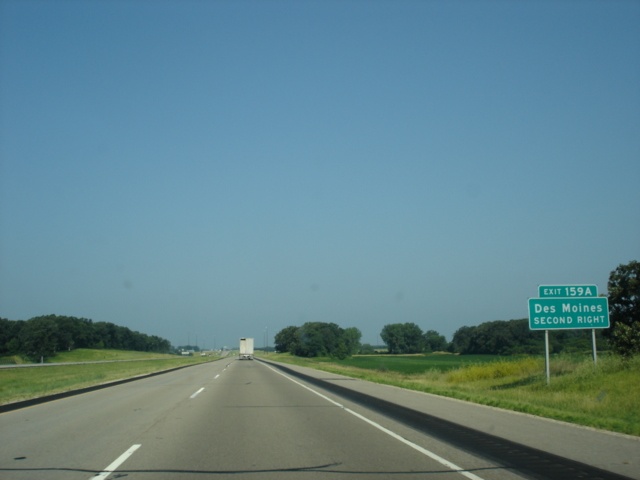 |
Use Exit 159A (Interstate 35 South) for 151 miles to Des Moines, the capital city of Iowa. The loop ramp was closed on this day due to construction. (Photo taken 7/13/05) |
 |
Interstate 90 West at Exit 159B - Interstate 35 North - Twin Cities. Minneapolis is 93 miles to the north, and St. Paul is 95 miles to the north. (Photo taken 7/13/05) |
 |
Interstate 90 West at the closed Exit 159A - Interstate 35 South - Albert Lea/Des Moines. (Photo taken 7/13/05) |
 |
Interstate 90 West approaching Exit 157 - Freeborn County 22 - 1 mile. Freeborn County 22 is known as Bridge Avenue through Albert Lea. (Photo taken 7/13/05) |
 |
Use southbound Bridge Avenue to the Albert Lea Municipal Airport. (Photo taken 7/13/05) |
 |
Interstate 90 West at Exit 157 - Freeborn County 22/Bridge Avenue. The ramp from Interstate 35 South to Interstate 90 East was also closed, which meant that traffic used this exit to access Interstate 90 East. (Photo taken 7/13/05) |
 |
Interstate 90 West approaching Exit 154 - Minnesota 13 - 1 1/4 miles. Minnesota 13 is 114 miles long and connects U.S. 65 in Albert Lea to Minnesota 149 in St. Paul. (Photo taken 7/13/05) |
 |
Use Minnesota 13 North for three miles to Manchester (pop. 550). (Photo taken 7/13/05) |
 |
Three and one-half miles south of this interchange is the northern terminus of U.S. 69. (Photo taken 7/13/05) |
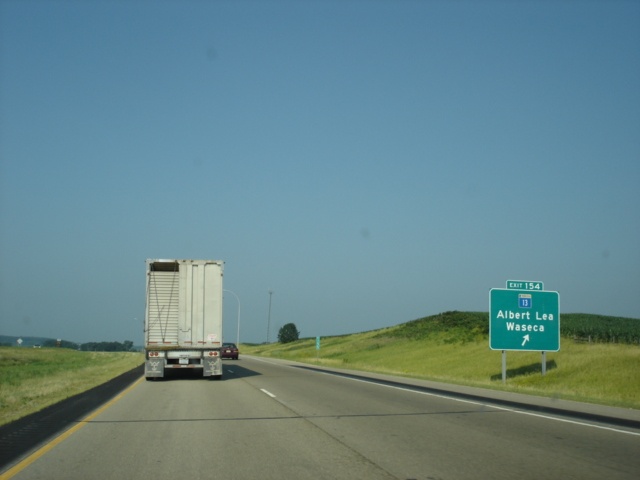 |
Interstate 90 West at Exit 154 - Minnesota 13 - Albert Lea/Waseca. The seat of Waseca County, the city of Waseca (pop. 8,493) is 29 miles to the north. (Photo taken 7/13/05) |
 |
The next rest area is 33 miles west of the Freeborn County 14 overpass. (Photo taken 7/13/05) |
 |
Interstate 90 West approaching Exit 146 - Minnesota 109/Freeborn County 6 - 2 miles. This is a rare button-copy ground-level sign still in use on a Minnesota interstate. (Photo taken 7/13/05) |
 |
Interstate 90 West approaching Exit 146 - Minnesota 109/Freeborn County 6 - 1 mile. Minnesota 109 connects Interstate 90 to U.S. 169, a span of 32.7 miles. (Photo taken 7/13/05) |
 |
Use Minnesota 109 West to the city of Wells, population 2,494. (Photo taken 7/13/05) |
 |
Interstate 90 West at Exit 146 - Minnesota 109/Freeborn County 6 - Alden/Mankato. A 45 mile drive via Minnesota 109 West and Minnesota 22 North awaits those going to the city of Mankato, population 32,427. (Photo taken 7/13/05) |
 |
Interstate 90 West approaching Exit 138 - Minnesota 22 - 1 mile. The state highway travels 166 miles from the Iowa state line to Minnesota 23 in Richmond. (Photo taken 7/13/05) |
 |
Interstate 90 West at Exit 138 - Minnesota 22 - Kiester/Wells. Kiester (pop. 540) is 10 miles to the south. (Photo taken 7/13/05) |
 |
Interstate 90 West approaching Exit 134 - Minnesota 253/Faribault County 21 - 1 mile. Minnesota 253 connects Interstate 90 to the 379-resident city of Bricelyn, a distance of six miles. (Photo taken 7/13/05) |
 |
Interstate 90 West at Exit 134 - Minnesota 253/Faribault County 21 - Bricelyn/Minnesota Lake. (Photo taken 7/13/05) |
 |
Interstate 90 West approaching Exit 128 - Minnesota 254/Faribault County 17 - 1 mile. Minnesota 254 is much like Minnesota 253; it is a spur route from Interstate b90 to the city of Frost, population 251. (Photo taken 7/13/05) |
 |
Interstate 90 West at Exit 128 - Minnesota 254/Faribault County 17 - Frost/Easton. (Photo taken 7/13/05) |
 |
Interstate 90 West approaching the Faribault County rest area - 2 1/4 miles. (Photo taken 7/13/05) |
 |
Interstate 90 West approaching Exit 119 - U.S. 169 - 1 mile. U.S. 169 is a major north-south route through Minnesota, connecting Blue Earth, Mankato, Anoka, Grand Rapids, Hibbing, and Virginia. (Photo taken 7/13/05) |
 |
Use U.S. 169 South to Elmore, located on the Iowa state line, and U.S. 169 North to Winnebago. (Photo taken 7/13/05) |
 |
Interstate 90 West at Exit 119 - U.S. 169 - Blue Earth. The rest area is one mile ahead. Blue Earth (pop. 3,621) is the seat of Faribault County. (Photo taken 7/13/05) |
 |
These gates are located at the gore points of major interchanges along Interstate 90 in southern Minnesota and are put down when the interstate is closed due to weather or other unsafe conditions. (Photo taken 7/13/05) |
 |
Interstate 90 West at the Faribault County rest area. (Photo taken 7/13/05) |
 |
Interstate 90 West approaching Exit 113 - Faribault County 1 - 1 mile. (Photo taken 7/13/05) |
 |
Interstate 90 West at Exit 113 - Faribault County 1 - Guckeen/Huntley. Guckeen is located just south of the interstate. Huntley is five miles to the north. (Photo taken 7/13/05) |
 |
Interstate 90 West approaching Exit 107 - Minnesota 262/Martin County 53 - 1 mile. Minnesota 262 is a 2-mile spur route from Interstate 90 north to Granada. (Photo taken 7/13/05) |
 |
Interstate 90 West at Exit 107 - Minnesota 262/Martin County 53 - East Chain/Granada. (Photo taken 7/13/05) |
 |
The next two exits serve the city of Fairmont, population 10,889. Exit 102 (Minnesota 15/Business Loop Interstate 90) is in three miles, and Exit 99 (Martin County 39) is in five miles. (Photo taken 7/13/05) |
 |
Interstate 90 West approaching Exit 102 - Minnesota 15/Business Loop Interstate 90 - 2 miles. Minnesota 15 is a 164-mile route from the Iowa state line to U.S. 10 in Sauk Rapids. (Photo taken 7/13/05) |
 |
Use Minnesota 15 North to Truman and Minnesota 15/Iowa 15 South to Armstrong, Iowa. (Photo taken 7/13/05) |
 |
Interstate 90 West approaching Exit 102 - Minnesota 15/Business Loop Interstate 90 - 1 mile. (Photo taken 7/13/05) |
 |
Interstate 90 West at Exit 102 - Minnesota 15/Business Loop Interstate 90 - Fairmont/Madelia. Madelia (pop. 2,340) is 27 miles to the north. (Photo taken 7/13/05) |
 |
Interstate 90 West approaching Exit 99 - Martin County 39 - 1 mile. (Photo taken 7/13/05) |
 |
Interstate 90 West at Exit 99 - Martin County 39 - Fairmont. (Photo taken 7/13/05) |
 |
Interstate 90 West approaching Exit 93 - Minnesota 263/Martin County 27 - 1 mile. Welcome, Minnesota, is home to 721 residents and is just south of this interchange. Ceylon (pop. 413) is the location of Minnesota 263's southern terminus, 11 miles to the south. (Photo taken 7/13/05) |
 |
Interstate 90 West at Exit 93 - Minnesota 263/Martin County 27 - Welcome/Ceylon. (Photo taken 7/13/05) |
 |
Interstate 90 West approaching Exit 87 - Minnesota 4 - 2 miles. Minnesota 4 is 162 miles long and connects the Iowa state line to Interstate 94. (Photo taken 7/13/05) |
 |
Interstate 90 West approaching Exit 87 - Minnesota 4 - 1 1/4 miles. Sherburn (pop. 1,082) is just to the south, and St. James, the seat of Watonwan County and home of 4,695 residents, is 24 miles to the north. (Photo taken 7/13/05) |
 |
Use Minnesota 4/Iowa 4 South for 22 miles to Estherville, the seat of Emmet County, Iowa. Head north on Minnesota 4 to the city of Trimont. (Photo taken 7/13/05) |
 |
Interstate 90 West at Exit 87 - Minnesota 4 - Sherburn/St. James. (Photo taken 7/13/05) |
 |
Interstate 90 West approaching Exit 80 - Jackson County 29 - 1 mile. Alpha (pop. 126) is just south of the interstate along old U.S. 16. (Photo taken 7/13/05) |
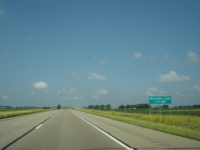 |
Use Jackson County 29 and Cottonwood County 1 North to Mountain Lake. (Photo taken 7/13/05) |
 |
Interstate 90 West at Exit 80 - Jackson County 29 - Alpha. (Photo taken 7/13/05) |
 |
Interstate 90 West approaching Exit 73 - U.S. 71 - 2 miles. U.S. 71 spends 423 miles in the North Star State, spanning from the Iowa state line to the Canadian border in International Falls. (Photo taken 7/13/05) |
 |
Use U.S. 71 South to the Minnesota West Community & Technical College. The college has five campuses, located in Canby, Granite Falls, Jackson, Pipestone, and Worthington. (Photo taken 7/13/05) |
 |
Use U.S. 71 South to Spirit Lake, Iowa. (Photo taken 7/13/05) |
 |
Use U.S. 71 North to the Kilen Woods State Park. (Photo taken 7/13/05) |
 |
Interstate 90 West approaching Exit 73 - U.S. 71 - 1 mile. This is the only exit for the Jackson County seat. The city of Jackson is home to 3,501 residents. (Photo taken 7/13/05) |
 |
Interstate 90 West at Exit 73 - U.S. 71 - Jackson/Windom. A rest area is located 1 1/2 miles ahead. (Photo taken 7/13/05) |
Page created: March 11, 2006
Last updated:
March 11, 2006