 |
Home Search OKRoads: |
|
|
Home Search OKRoads: |
Interstate 90 Ohio
Westbound - Interstate 271 to Interstate
71
|
Highway Information |
|
| Miles | 244.75 |
| Counties Traveled Through |
Williams, Fulton, Lucas, Wood, Ottawa, Sandusky, Erie, Lorain, Cuyahoga, Lake, Ashtabula |
| Cities |
Toledo, Elyria, Cleveland, Ashtabula, Conneaut |
| Major Junctions |
Interstate 75 (Exit 64) Interstate 280 Interstate 80 Interstate 71 Interstate 490 Interstate 77 Interstate 271 |
| OKRoads Coverage | |
| Miles Driven by OKRoads (Percentage) |
75 (31%) |
| Western End of Interstate Driven |
Interstate 71 |
| Eastern End of Interstate Driven |
Pennsylvania State Line |
Pictures
Westbound:
Pennsylvania State Line to Interstate 271
Interstate 271 to Interstate 71
| Interstate 90 West | |
 |
Interstate 90 West approaching Exit 187 - Ohio 84 - 1 mile. The western terminus of the state highway is less than 1/2 mile south of the upcoming interchange. Interstate 90 also intersects Ohio 84 at Exit 235. (Photo taken 7/10/05) |
 |
Interstate 90 West approaching Exit 187 - Ohio 84 - 1/2 mile. Bishop Road is a main north-south arterial through Wickliffe, Willoughby Hills, and Highland Heights. (Photo taken 7/10/05) |
 |
Use Bishop Road north to the city of Wickliffe (pop. 13,484), and south to the city of Willoughby Hills (pop. 8,595), and the city of Richmond Heights (pop. 10,944). (Photo taken 7/10/05) |
 |
Interstate 90 West at Exit 187 - Ohio 84/Bishop Road. The top picture shows a reflective sign prior to the departure of the exit ramp. The bottom picture is the signage at the actual departure of the off-ramp. (Photos taken 7/10/05) |
 |
|
 |
Interstate 90 West approaching Exit 186 - U.S. 20 - 1/2 mile. This stretch of interstate has been reconstructed recently, with an extra lane added and new signage erected. (Photo taken 7/10/05) |
 |
Interstate 90 West at Exit 186 - U.S. 20/Euclid Avenue. This interchange is directly on the Cuyahoga-Lake county line. (Photo taken 7/10/05) |
 |
Interstate 90 West approaching Exit 185 - Ohio 2 East - Next Right. This sign is about 1/2 mile south of the interchange. The BGS ahead indicates we are entering Cuyahoga County. (Photo taken 7/10/05) |
 |
Interstate 90 West approaching Exit 185 - Ohio 2 East - 1/4 mile. When construction is completed, three lanes of westbound Interstate 90 traffic will travel through this interchange. (Photo taken 7/10/05) |
 |
Interstate 90 West at Exit 185 - Ohio 2 East - Painesville. The city of Painesville (pop. 17,503) is 17 miles to the northeast. (Photo taken 7/10/05) |
 |
Interstate 90 West prepares to merge onto the Lakeland Parkway (Ohio 2) as the one-half mile advance signage appears for Ohio 175, East 260th Street, and Babbitt Road. North-south streets throughout Cuyahoga County are numbered. (Photo taken 7/10/05) |
| Interstate 90 and Ohio 2 West | |
 |
Interstate 90 and Ohio 2 West approaching Exit 184 - Ohio 175/East 260th Street - 1/4 mile. The interstate crosses over the state highway just past the speed limit 60 sign. Lakeland Boulevard serves as a frontage road in both directions of Interstate 90. (Photo taken 7/10/05) |
 |
Interstate 90 and Ohio 2 West at Exit 184 - Ohio 175/East 260th Street - Babbitt Road. (Photo taken 7/10/05) |
 |
Interstate 90 and Ohio 2 West approaching Exit 183 - East 222nd Street - 1/2 mile, and Exit 182 - East 200th Street - 1 mile. (Photo taken 7/10/05) |
 |
Interstate 90 and Ohio 2 West approaching Exit 183 - East 222nd Street - 1/4 mile. Sound walls line much of the westbound shoulder between the freeway and Lakeland Boulevard. (Photo taken 7/10/05) |
 |
Interstate 90 and Ohio 2 West at Exit 183 - East 222nd Street. (Photo taken 7/10/05) |
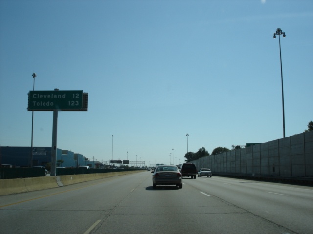 |
Mileage sign on Interstate 90 and Ohio 2 West just past Exit 183. Toledo makes an appearance on a distance sign for the first time, 123 miles to the east of the northwest Ohio city. Downtown Cleveland is 12 miles ahead. (Photo taken 7/10/05) |
 |
Interstate 90 and Ohio 2 West approaching Exit 182B - East 200th Street - 1/4 mile, and Exit 182A - East 185th Street - 1 mile. Lakeland Boulevard ends just before the departure of Exit 182A. East 200th Street is the eastern boundary of the city of Cleveland. (Photo taken 7/10/05) |
 |
Interstate 90 and Ohio 2 West at Exit 182B - East 200th Street. (Photo taken 7/10/05) |
 |
Interstate 90 and Ohio 2 West approaching Exit 182A - East 185th Street - 1/4 mile. (Photo taken 7/10/05) |
 |
Interstate 90 and Ohio 2 West at Exit 182A - East 185th Street. The East 185th Street Festival is a yearly summertime occurrence along the north-south arterial. (Photo taken 7/10/05) |
 |
Interstate 90 and Ohio 2 West approaching Exit 181 - East 156th Street - 1 mile. Tractor-trailers are prohibited from using this exit, as East 156th Street is a residential street. (Photo taken 7/10/05) |
 |
Interstate 90 and Ohio 2 West approaching Exit 181 - East 156th Street - 1/2 mile, and Exit 180 - East 152nd Street and East 140th Street - 1 mile. (Photo taken 7/10/05) |
 |
Interstate 90 and Ohio 2 West approaching Exit 181 - East 156th Street - 1/4 mile, and Exit 180 - East 152nd Street and East 140th Street - 3/4 mile. This is almost exactly like the sign bridge we saw one-quarter mile prior to this one, except for the distances being different. (Photo taken 7/10/05) |
 |
Interstate 90 and Ohio 2 West at Exit 181 - East 156th Street. Exit 180 is 1/2 mile ahead. (Photo taken 7/10/05) |
 |
Interstate 90 and Ohio 2 West at Exit 180 - East 152nd Street and East 140th Street. (Photo taken 7/10/05) |
 |
Interstate 90 and Ohio 2 West approaching Exit 178 - Eddy Road - 1 mile. For about two miles, Interstate 90 makes up the southern border of the lakefront village of Bratenahl. The village has a population of 1,337 according to the 2000 census. (Photo taken 7/10/05) |
 |
Interstate 90 and Ohio 2 West approaching Exit 178 - Eddy Road - 1/2 mile. Bratenahl is known for its many trees and lakefront views. (Photo taken 7/10/05) |
 |
Interstate 90 and Ohio 2 West approaching Exit 178 - Eddy Road - 1/4 mile. (Photo taken 7/10/05) |
 |
Interstate 90 and Ohio 2 West at Exit 178 - Eddy Road - Bratenahl. Lake Erie is less than one-third mile to the north. (Photo taken 7/10/05) |
 |
Interstate 90 and Ohio 2 West approaching Exit 177 - University Circle/Martin Luther King Jr. Drive - 1 mile. University Circle takes up one square-mile and includes the Cleveland Museum of Art, Case Western Reserve University, and the Cleveland Play House. (Photo taken 7/10/05) |
 |
Interstate 90 and Ohio 2 West approaching Exit 177 - Martin Luther King Jr. Drive - 1/2 mile, and Exit 176 - East 72nd Street - 1 mile. (Photo taken 7/10/05) |
 |
Interstate 90 and Ohio 2 West approaching Exit 177 - Martin Luther King Jr. Drive - 1/4 mile, and Exit 176 - East 72nd Street - 3/4 mile. The sound wall gives way to trees as we enter park land near Lake Erie. (Photo taken 7/10/05) |
 |
Interstate 90 and Ohio 2 West at Exit 177 - Martin Luther King Jr. Drive - University Circle. (Photo taken 7/10/05) |
 |
Interstate 90 and Ohio 2 West at Exit 176 - East 72nd Street. A pedestrian bridge crosses the interstate as we get ready to see Lake Erie on one side and downtown Cleveland on the other. (Photo taken 7/10/05) |
 |
Interstate 90 and Ohio 2 West approaching Exit 175 - East 55th Street/Marginal Road - 1/2 mile. Marginal Road acts as a frontage road of Interstate 90 and Ohio 2 along the shores of Lake Erie, which is visible on the right. (Photo taken 7/10/05) |
 |
Interstate 90 and Ohio 2 West approaching Exit 175 - East 55th Street/Marginal Roads - 1/4 mile. North Marginal Road and South Marginal Road run along the north and south sides of Interstate 90 and Ohio 2, respectively. (Photo taken 7/10/05) |
 |
Interstate 90 and Ohio 2 West at Exit 175 - East 55th Street/Marginal Roads. Use North Marginal Road westbound to the Burke Lakefront Airport. The airport is used once per year for the Grand Prix of Cleveland. Interstate 71 is signed for the first time at this point, even though it does not begin until Exit 170B. (Photo taken 7/10/05) |
 |
Exit 174B is the continuation of Ohio 2 westbound to downtown Cleveland. Use Exit 174B to the Great Lakes Science Center and the Rock and Roll Hall of Fame. (Photo taken 7/10/05) |
 |
The speed limit falls to 50 as we approach Exit 174B for Ohio 2 West in about one mile. For those continuing on Interstate 90, they will get to experience the infamous "Dead Man's Curve," a sharp curve that Interstate 90 makes at the upcoming interchange. The curve is signed with an advisory speed of 35 mph. (Photo taken 7/10/05) |
 |
Continue on Ohio 2 West to the Cleveland Amtrak station, the Cleveland Browns Stadium, and the Cleveland Convention Center. (Photo taken 7/10/05) |
 |
Interstate 90 and Ohio 2 West approaching Exit 174B - Ohio 2 West - 1/2 mile. Ohio 2 is actually the through highway, as that highway continues straight ahead, while Interstate 90 makes a sharp curve to the south. (Photo taken 7/10/05) |
 |
This advisory sign is posted about 1/4 mile prior to Dead Man's Curve and Exit 174B. Rumble strips are also located on the two inside lanes. Notice the change in pavement between the Interstate 90 lanes and the Ohio 2 lanes. (Photo taken 7/10/05) |
 |
Interstate 90 and Ohio 2 West at Exit 174B - Ohio 2 West - Downtown Cleveland. If continuing on Interstate 90, slow down here; this curve is one of the sharpest on the interstate system. (Photo taken 7/10/05) |
| Interstate 90 West | |
 |
Interstate 90 West approaching Exit 173C - Superior Avenue/St. Clair Avenue - 1/2 mile. U.S. 6 runs along Superior Avenue through downtown Cleveland, but no mention of the federal highway is made from Interstate 90. (Photo taken 7/10/05) |
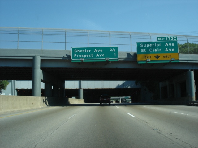 |
Interstate 90 West approaching Exit 173C - U.S. 6/Superior Avenue and St. Clair Avenue - 1/4 mile. Two other exits are located within one mile; Exit 173B at Chester Avenue (U.S. 322) in 3/4 mile and Exit 173A at Prospect Avenue in one mile. (Photo taken 7/10/05) |
 |
Interstate 90 West at Exit 173C - U.S. 6/Superior Avenue and St. Clair Avenue. The St. Clair Avenue overpass supports these signs. (Photo taken 7/10/05) |
 |
Use Exit 173A (Prospect Avenue) to Jacobs Field (home of the Indians), the recently-renamed Quicken Loans Arena (home of the Cavaliers), and the Tower City Center. (Photo taken 7/10/05) |
 |
Use U.S. 322 (Chester Avenue) West to Cleveland State University and Playhouse Square. (Photo taken 7/10/05) |
 |
Interstate 90 West at Exit 173B - U.S. 322/Chester Avenue. As was the case with U.S. 6 and Superior Avenue, there is no mention of U.S. 322 made here. U.S. 322 meets its western terminus in downtown Cleveland at U.S. 6. (Photo taken 7/10/05) |
 |
Again, use Exit 173A to the Quicken Loans Arena (formerly known as Gund Arena) and Jacobs Field. Exit 173A for Prospect Avenue is 1/8 mile ahead, followed by Exit 172A for Interstate 77 South in 3/4 mile and Exit 171 for West 14th Street in 1 3/4 mile. (Photo taken 7/10/05) |
 |
Interstate 90 West at Exit 173A - Prospect Avenue. U.S. 20 (Euclid Avenue) passes over the interstate here. Interstate 77 begins in one-half mile. (Photo taken 7/10/05) |
 |
Interstate 90 West approaching Exit 172A - Interstate 77 South - 1/4 mile. Interstate 77 travels through Ohio, West Virginia, Virginia, North Carolina, and South Carolina along its journey and ends 610 miles to the south at Interstate 26 in Columbia, South Carolina. (Photo taken 7/10/05) |
 |
Interstate 90 West at Exit 172A - Interstate 77 South - Akron. A 36 mile drive separates this interchange from the city of Akron. Interstate 71 begins in 1 1/2 miles. (Photo taken 7/10/05) |
 |
Interstate 90 West approaching Exit 171 - West 14th Street/Abbey Avenue - 1 mile. We finally leave the downtown Cleveland area behind and the surrounding landscape opens up. (Photo taken 7/10/05) |
 |
A view of Jacobs Field from Interstate 90 between Interstate 77 and West 14th Street. The stadium opened in 1994 and was sold out for 455 consecutive games between mid-1995 and April 2001. (Photo taken 7/10/05) |
 |
Interstate 90 West approaching Exit 170B - Interstate 71 South - 3/4 mile. For the second time in five miles, Interstate 90 exits off the mainline freeway. Interstate 490 also begins at the upcoming interchange, connecting Interstate 90 to Interstate 77. There is no direct connection from Interstate 90 West to Interstate 490 East. (Photo taken 7/10/05) |
 |
Interstate 90 West approaching Exit 171 - West 14th Street/Abbey Avenue - 1/4 mile. (Photo taken 7/10/05) |
 |
Interstate 90 West at Exit 171 - West 14th Street/Abbey Avenue. This sign is located at the gore point. Visible to the far right is the split of the off-ramp to West 14th Street to the left and Abbey Avenue to the right. (Photo taken 7/10/05) |
 |
Interstate 90 West approaching Exit 170B - Interstate 71 South - 1/4 mile. Columbus, the state capital and largest city in the state, is 141 miles to the southwest. (Photo taken 7/10/05) |
 |
Interstate 90 West at Exit 170B - Interstate 71 South - Columbus. Interstate 90 exits off to the right as Interstate 71 takes over the mainline. (Photo taken 7/10/05) |
Page created: February 02, 2006
Last updated:
February 03, 2006