 |
Home Search OKRoads: |
|
|
Home Search OKRoads: |
Interstate 26 South Carolina
Westbound - Interstate 20 to North
Carolina State Line
|
Highway Information |
|
| Miles | 220.95 |
| Counties Traveled Through |
Spartanburg, Laurens, Newberry, Richland, Lexington, Calhoun, Orangeburg, Dorchester, Berkeley, Charleston |
| Cities |
Spartanburg, Clinton, |
| Major Junctions |
Interstate 85 (Exits 18A-B)
Business Loop Interstate 385 Interstate 20 Interstate 126 Interstate 77 Interstate 95 Interstate 526 U.S. 17 |
| OKRoads Coverage | |
| Miles Driven by OKRoads (Percentage) |
221 (100%) |
| Western End of Interstate Driven |
North Carolina State Line |
| Eastern End of Interstate Driven |
U.S. 17 |
Pictures
Westbound:
Interstate 95 to Interstate 20
Interstate 20 to North Carolina State Line
| Interstate 26 and U.S. 76 West | |
 |
Interstate 26 and U.S. 76 West continue northwest of Interstate 20. The next interchange serves St. Andrews Road. Following the six-ramp partial cloverleaf interchange are interchanges for Piney Grove Road (2 1/4 miles), Harbison Boulevard (3 1/2 miles), and Lake Murray Boulevard (4 1/2 miles). (Photo taken 7/7/05) |
 |
Interstate 26 and U.S. 76 West at Exit 106B - St. Andrews Road eastbound. St. Andrews Road is a main connection between U.S. 176 east of the interstate to the town of Irmo. Interstate 26 motorists should continue to Exit 102A to Irmo. (Photo taken 7/7/05) |
 |
Interstate 26 and U.S. 76 West at Exit 106A - St. Andrews Road westbound. Irmo is 5.5 miles to the northwest. (Photo taken 7/7/05) |
 |
Interstate 26 and U.S. 76 West approaching Exit 104 - Piney Grove Road - 1 mile. The east-west arterial connects St. Andrews Road to U.S. 176, which runs parallel to the interstate one mile to the east between Exit 101 and Interstate 126. (Photo taken 7/7/05) |
 |
Interstate 26 and U.S. 76 West approaching Exit 104 - Piney Grove Road - 1/2 mile. This is a similar sign to the one seen just past Interstate 20, except we are closer to the interchanges. (Photo taken 7/7/05) |
 |
Interstate 26 and U.S. 76 West at Exit 104 - Piney Grove Road. The arterial is 2.9 miles long. (Photo taken 7/7/05) |
 |
Interstate 26 and U.S. 76 West approaching Exit 103 - Harbison Boulevard - 1/2 mile. This sign lists the final three exits in the Columbia metropolitan area. U.S. 76 will split from the interstate at Exit 101A. (Photo taken 7/7/05) |
 |
Interstate 26 and U.S. 76 West at the loop ramp that is Exit 103 - Harbison Boulevard. This is another east-west arterial between St. Andrews Road and U.S. 176. (Photo taken 7/7/05) |
 |
The next interchange is a six-ramp partial cloverleaf at South Carolina 60. Head west on the state highway via Exit 101A to the Harbison Campus of Midlands Technical College and to Lake Murray Country. The lake is five miles west of this interchange. (Photo taken 7/7/05) |
 |
Interstate 26 and U.S. 76 West approaching Exits 102B-A - South Carolina 60/Lake Murray Boulevard - 1/2 mile. Spartanburg is 83 miles ahead via Interstate 26. (Photo taken 7/7/05) |
 |
Interstate 26 and U.S. 76 West at Exit 102B - South Carolina 60 East. The state highway connects South Carolina 6 on the east shore of Lake Murray to U.S. 176, a distance of five miles. (Photo taken 7/7/05) |
 |
Interstate 26 and U.S. 76 West at Exit 102A - South Carolina 60/Lake Murray Boulevard westbound - Irmo. Construction in recent years has expanded this once half-interchange to a five-ramp partial cloverleaf, with an extra exit provided from Interstate 26 and U.S. 76 West to South Carolina 60 West. The next interchange is also a five-ramp partial cloverleaf at U.S. 176. (Photo taken 7/7/05) |
 |
Interstate 26 and U.S. 76 West at Exit 101B - U.S. 176/Broad River Road eastbound. Broad River Road provides an alternate route to Interstate 26 between Irmo and downtown Columbia. U.S. 176 will continue to stay near Interstate 26 for most of its route between Hendersonville, North Carolina, and Goose Creek, 15 miles northwest of downtown Charleston. (Photo taken 7/7/05) |
 |
Interstate 26 and U.S. 76 West split at Exit 101A. U.S. 76 and U.S. 176 duplex for 3.1 miles before splitting. U.S. 76 heads in a more westerly direction toward Anderson, while U.S. 176, again, stays close to Interstate 26. Ballentine and White Rock are communities located on U.S. 76 west of its split from U.S. 176. Interstate 26 westbound narrows to two lanes after this interchange. (Photo taken 7/7/05) |
| Interstate 26 West | |
 |
Interstate 26 West approaching Exit 97 - U.S. 176 - 1 mile. The interchange is two miles north of the federal highway's split from U.S. 76. (Photo taken 7/7/05) |
 |
Interstate 26 West at Exit 97 - U.S. 176 - Peak. The town has an estimated population of 62 and is located near South Carolina 213, nine miles to the north. (Photo taken 7/7/05) |
 |
Interstate 26 West approaching Exit 91 - Columbia Avenue - 1 mile. Columbia Avenue provides the main connection between Interstate 26 and the town of Chapin, population 665. (Photo taken 7/7/05) |
 |
Head west on Columbia Avenue for 12 miles to the Dreher Island State Recreational Area. Located on the western shore of Lake Murray, the area includes 12 miles of shoreline and 348 acres of land. (Photo taken 7/7/05) |
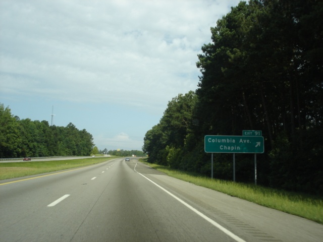 |
Interstate 26 West at Exit 91 - Columbia Avenue/Chapin. (Photo taken 7/7/05) |
 |
Interstate 26 West approaching Exit 85 - South Carolina 202 - 1 mile. South Carolina 202 is a 4.5 mile north-south connector between U.S. 76 and U.S. 176. (Photo taken 7/7/05) |
 |
Interstate 26 West at Exit 85 - South Carolina 202 - Pomaria/Little Mountain. The town of Little Mountain is 1.8 miles to the south, and Pomaria is located on U.S. 176 four miles to the north. (Photo taken 7/7/05) |
 |
Interstate 26 West approaching Exit 82 - South Carolina 773 - 1 mile. South Carolina 773 and South Carolina 202 could be brothers; both state highways connect the same highways, just at different points. South Carolina 773 is 5.4 miles long, slightly more than South Carolina 202. (Photo taken 7/7/05) |
 |
Interstate 26 West at Exit 82 - South Carolina 773 - Pomaria/Prosperity. Take South Carolina 773 South to U.S. 76 West to the town of Prosperity, a total distance of 5.4 miles from Exit 82. (Photo taken 7/7/05) |
 |
The next three interchanges serve the city of Newberry, the seat of the county of the same name. The city has 10,700 residents and is served by U.S. 76 and South Carolina state highways 34, 121, 219, and 395. (Photo taken 7/7/05) |
 |
Interstate 26 West approaching Exit 76 - South Carolina 219 - 1 mile. South Carolina 219 is an east-west highway between, you guessed it, U.S. 76 and U.S. 176. This highway's distance is 9.0 miles between the two federal highways. South Carolina 219 is Main Street through Prosperity. (Photo taken 7/7/05) |
 |
Use South Carolina 219 west to the Newberry Opera House and Newberry College. (Photo taken 7/7/05) |
 |
Interstate 26 West at Exit 76 - South Carolina 219 - Newberry. The city's business district is five miles to the west. (Photo taken 7/7/05) |
 |
Interstate 26 West approaching Exit 74 - South Carolina 34 - 1 mile. The longest of the east-west highways that serve Newberry, South Carolina 34 begins at U.S. 25 in south Greenwood and heads east through Newberry, Winnsboro, Camden, Bishopville, Darlington, and Dillon, where the state highway's eastern terminus is located. (Photo taken 7/7/05) |
 |
Use South Carolina 34 west to the Ninety Six National Historic Site, which depicts a colonial trading village. The site is 37 miles to the southwest. (Photo taken 7/7/05) |
 |
Interstate 26 West at Exit 74 - South Carolina 34 - Winnsboro/Newberry. A 32 mile eastbound drive separates Exit 74 from the seat of Fairfield County. South Carolina 34 makes up the southern boundary of the Sumter National Forest between U.S. 76 in Newberry and South Carolina 215. (Photo taken 7/7/05) |
 |
Interstate 26 West approaching Exit 72 - South Carolina 121 - 1 mile. South Carolina 121 begins at the Georgia state line in North Augusta and goes north to U.S. 176 north of Newberry, and duplexes with U.S. 176 and South Carolina 72 to Chester before continuing northeast to Rock Hill. (Photo taken 7/7/05) |
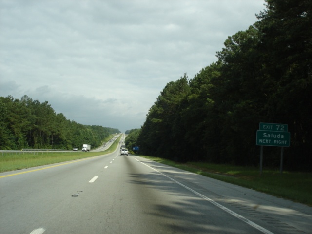 |
Saluda (pop. 2,971) is located at the confluence of U.S. 178, U.S. 378, and South Carolina 121. The seat of Saluda County is 27 miles to the south. (Photo taken 7/7/05) |
 |
Interstate 26 West at Exit 72 - South Carolina 121 - Whitmire/Union. The town of Whitmire (pop. 1,527) is 14 miles away, while the city of Union (pop. 8.377) is 30 miles away. Both are located on U.S. 176, which deviates slightly from Interstate 26's shadow between Spartanburg and Newberry. (Photo taken 7/7/05) |
 |
Interstate 26 West approaching Exit 66 - Road 32 - 1 mile. Also known as Jalapa Road, Road 32 is a 10.2-mile road from U.S. 76 at the community of Jalapa northward to South Carolina 66 west of Whitmire. (Photo taken 7/7/05) |
 |
Interstate 26 West at Exit 66 - Road 32/Jalapa Road. (Photo taken 7/7/05) |
 |
The final westbound rest area in the Palmetto State is located near mile marker 62, one mile ahead of this advance sign. (Photo taken 7/7/05) |
 |
Interstate 26 West at the Newberry County rest area. The interstate will enter Laurens County prior to Exit 60, the next interchange. (Photo taken 7/7/05) |
 |
Interstate 26 West at Exit 60 - South Carolina 66 - Whitmire/Joanna. The state highway begins at South Carolina 56 three miles west of Joanna and ends at South Carolina 72 in Whitmire. (Photo taken 7/7/05) |
 |
The next two exits serve the city of Clinton, home to 8,985 residents. Use Exit 52 (South Carolina 56) to the Musgrove Mill Historic Site, six miles northeast of the interchange. Exit 54 (South Carolina 72) is still ahead prior to Exit 52. (Photo taken 7/7/05) |
 |
Interstate 26 West approaching Exit 54 - South Carolina 72 - 1 mile. South Carolina 72 is a main east-west state highway through Greenwood, Clinton, Whitmire, Chester, and Rock Hill. (Photo taken 7/7/05) |
 |
Use South Carolina 72 west to Presbyterian College, located in Clinton. The city of Greenwood (pop. 22,242) is 30 miles to the southwest. (Photo taken 7/7/05) |
 |
Interstate 26 West at Exit 54 - South Carolina 72 - Clinton. (Photo taken 7/7/05) |
 |
Interstate 26 West approaching Exit 52 - South Carolina 56 - 1 mile. The north-south state highway parallels Interstate 26 to its east between Clinton and Spartanburg. (Photo taken 7/7/05) |
 |
Interstate 26 West at Exit 52 - South Carolina 56 - Cross Anchor/Clinton. Cross Anchor is located at the intersection of South Carolina 49 and South Carolina 56, and is 12 miles north of Exit 52. (Photo taken 7/7/05) |
 |
Interstate 26 West approaching Exit 51 - Interstate 385 North - 1/2 mile. Interstate 385 traverses 42.16 miles from Interstate 26 to downtown Greenville. (Photo taken 7/7/05) |
 |
Interstate 26 West expands to three lanes in anticipation of the beginning of Interstate 385. The left lane will exit to Interstate 385, while motorists in the middle lane have a choice of interstates. (Photo taken 7/7/05) |
 |
Interstate 26 West at Exit 51 - Interstate 385 North - Laurens/Greenville. Interstate 385 has two interchanges for the the city of Laurens; Exit 5 (South Carolina 49) and Exit 9 (U.S. 221). (Photo taken 7/7/05) |
 |
Interstate 26 West approaching Exit 44 - South Carolina 49 - 1 mile. South Carolina 49 constitutes 77.7 miles from U.S. 221 in north Laurens to the North Carolina state line near Charlotte. (Photo taken 7/7/05) |
 |
Interstate 26 West at Exit 44 - South Carolina 49 - Cross Anchor/Union. The city of Union (pop. 8,377) is 19 miles to the east. (Photo taken 7/7/05) |
 |
Interstate 26 West approaching Exit 41 - South Carolina 92 - 1 mile. South Carolina 92 begins at South Carolina 49 one mile east of Interstate 26 at Exit 44 and is a short east-west highway connecting Gray Court, Lanford, and Enoree. South Carolina 92 closely parallels Interstate 26 between exits 44 and 41. (Photo taken 7/7/05) |
 |
Interstate 26 West at Exit 41 - South Carolina 92. Enoree is 2.6 miles to the west. (Photo taken 7/7/05) |
 |
Interstate 26 West approaching Exit 38 - South Carolina 146 - 1 mile. The northwest-to-southeast highway begins at U.S. 276 in Greenville and ends 6.3 miles to the southeast of Exit 38 near Cross Anchor. (Photo taken 7/7/05) |
 |
Interstate 26 West at Exit 38 - South Carolina 146 - Woodruff. The city of Woodruff is seven miles to the west and is home to 4,147 residents. (Photo taken 7/7/05) |
 |
Interstate 26 West approaching Exit 35 - Walnut Grove Road - 1 mile. Walnut Grove Road, which transitions into the S.J. Workman Highway west of the interstate, provides an extra connection to Woodruff. The roadway ends at South Carolina 146 in east Woodruff. (Photo taken 7/7/05) |
 |
Interstate 26 West at Exit 35 - Walnut Grove Road/Woodruff. (Photo taken 7/7/05) |
 |
The next interchange is Exit 28, serving U.S. 221. It is the first of eight to serve the city of Spartanburg. With a population of 38,599, it is the 8th largest city in the Palmetto State. (Photo taken 7/7/05) |
 |
Interstate 26 West approaching Exit 28 - U.S. 221 - 1 mile. Nationally, U.S. 221 goes from Perry, Florida, to Lynchburg, Virginia. As for its route in South Carolina, the federal highway connects McCormick, Greenwood, Laurens, Woodruff, and Spartanburg. (Photo taken 7/7/05) |
 |
Roebuck is located just off of U.S. 221 along South Carolina 215 between Interstate 26 and Spartanburg. Use U.S. 221 North to Spartanburg, home of Converse College and Wofford College. (Photo taken 7/7/05) |
 |
Also use U.S. 221 North to the Walnut Grove Plantation, located in Roebuck. (Photo taken 7/7/05) |
 |
Interstate 26 West at Exit 28 - U.S. 221 - Spartanburg-South/Moore. Moore is located on South Carolina 290, which has its southern terminus within one mile west of Interstate 26. (Photo taken 7/7/05) |
 |
Mileage sign on Interstate 26 West at mile marker 27. Interstate 85 is 10 miles away, and the city of Asheville, North Carolina, is 72 miles ahead. (Photo taken 7/7/05) |
 |
Interstate 26 West approaching Exit 22 - South Carolina 296 - 1 mile. Reidville Road is a main east-west arterial through southwest Spartanburg. (Photo taken 7/7/05) |
 |
Interstate 26 West at Exit 22 - South Carolina 296/Reidville Road. Construction was underway to replace a diamond interchange with a single-point urban interchange to coincide with a widening project along the state highway. (Photo taken 7/7/05) |
 |
From here on, these pictures were taken during a driving rainstorm. The remnants of Tropical Storm Cindy were passing through the Piedmont on this July day, which made road sign photography a hassle. The next interchange is Exits 21A-B, serving U.S. 29. Use U.S. 29 North (Exit 21B) to Spartanburg Methodist College. (Photo taken 7/7/05) |
 |
Interstate 26 West approaching Exit 21B - U.S. 29 North - Next Right. A compact cloverleaf interchange facilitates movements between Interstate 26 and U.S. 29. (Photo taken 7/7/05) |
 |
Interstate 26 West at Exit 21B - U.S. 29 North - Spartanburg. Downtown is four miles to the east. Westgate Mall takes up the northeast quadrant of this interchange. An oddity about this interchange is that Interstate 26 is an east-west highway, and U.S. 29 is a north-south highway, yet at this interchange, Interstate 26 is traveling north-south while U.S. 29 travels east-west. (Photo taken 7/7/05) |
 |
Interstate 26 West at Exit 21A - U.S. 29 South - Greer. The city of Greer is 14 miles to the west. (Photo taken 7/7/05) |
 |
Mileage sign on Interstate 26 West, two miles south of Business Loop Interstate 85, the original route of Interstate 85 through Spartanburg. Modern Interstate 85 is one mile to the north in three miles. (Photo taken 7/7/05) |
 |
Interstate 26 West approaching Exit 19B - Business Loop Interstate 85 North - 1/2 mile. (Photo taken 7/7/05) |
 |
Interstate 26 West at Exit 19B - Business Loop Interstate 85 North - Spartanburg. The next exit (Exit 19A) for the business loop southbound does not receive any control cities, because it will transition into mainline Interstate 85 in two miles. (Photo taken 7/7/05) |
 |
Interstate 26 West at Exit 18B - Interstate 85 North. The Queen City is a 75 mile drive from this directional cloverleaf interchange. (Photo taken 7/7/05) |
 |
Interstate 26 West at Exit 16 - John Dodd Road. The arterial connects South Carolina 129 to U.S. 176 while bypassing Spartanburg to its north and west. (Photo taken 7/7/05) |
 |
Interstate 26 West at Exit 10 - South Carolina 292 - Inman. South Carolina 292 is a 11.3 mile north-south highway between South Carolina 129 in Lyman and South Carolina 9 two miles north of this interchange. Inman is three miles to the south. (Photo taken 7/7/05) |
 |
Interstate 26 West approaching Exit 5 - South Carolina 11 - 1 mile. South Carolina 11 is the Cherokee Foothills National Scenic Byway through northern South Carolina. Chesnee (population 1,019) is located at the intersection of South Carolina 11 and U.S. 221 and is 16 miles to the east. (Photo taken 7/7/05) |
 |
Interstate 26 West approaching Exit 1 - South Carolina 14 - 1 mile. South Carolina 14 is a north-south highway that begins at Exit 1 and extends southward through Greer before ending at U.S. 76 in Laurens. (Photo taken 7/7/05) |
 |
Interstate 26 West at Exit 1 - South Carolina 14 - Landrum. The rain began to subside, at least temporarily, at this point. (Photo taken 7/7/05) |
 |
Landrum is at the intersection of U.S. 176 and South Carolina 14, two miles to the west. Road 128 extends 1.3 miles to the northeast to the North Carolina state line. (Photo taken 7/7/05) |
| Scenes Related to Interstate 26 | |
 |
South Carolina 14 North at Interstate 26 East near Landum at the interstate's Exit 1. The state capital of South Carolina is 110 miles to the south. (Photo taken 7/7/05) |
 |
South Carolina 14 North at Interstate 26 West. Asheville, North Carolina is 45 miles to the northwest. (Photo taken 7/7/05) |
 |
South Carolina 14 South at Interstate 26 East. This rainy view also shows the first few hundred feet of the state highway. (Photo taken 7/7/05) |
Page created: December 04, 2005
Last updated:
December 11, 2005