 |
Home Search OKRoads: |
|
|
Home Search OKRoads: |
Interstate 40 North Carolina
Eastbound - Interstate 95 to Wilmington
|
Highway Information |
|
| Miles | 419.40 |
| Counties Traveled Through |
Haywood, Buncombe, McDowell, Burke, Catawba, Iredell, Davie, Forsyth, Guilford, Alamance, Orange, Durham, Wake, Johnston, Sampson, Duplin, Pender, New Hanover |
| Cities |
Asheville, Morganton, Hickory, Statesville, Winston-Salem, Greensboro, Burlington, Durham, Raleigh, Smithfield, Wilmington |
| Major Junctions |
Interstate 26/ Interstate 240 (Exits 46A-B)
Interstate 77 Interstate 85 Interstate 540 Interstate 440 Interstate 95 |
| OKRoads Coverage | |
| Miles Driven by OKRoads (Percentage) |
419 (100%) |
| Western End of Interstate Driven |
Tennessee State Line |
| Eastern End of Interstate Driven |
North Carolina 132 |
Pictures
Eastbound:
Tennessee State Line to Canton
Interstate 40/Interstate 85 duplex
Interstate 85 North to Interstate 95
| Interstate 40 East | |
 |
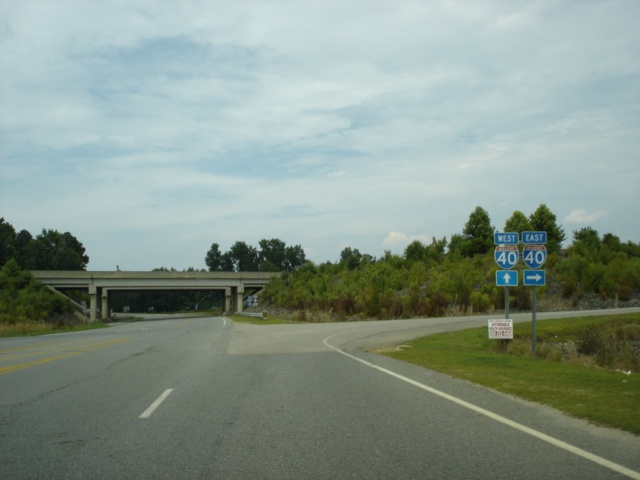
Just past the Interstate 95 junction, a sign appears informing us that the North Carolina Aquarium at Fort Fisher is 117 miles ahead. The eastern terminus of Interstate 40 is 90 miles away. (Photo taken 7/6/05) |
 |
Interstate 40 East approaching Exit 334 - North Carolina 96 - 2 miles. North Carolina 96 begins 5.4 miles to the south at North Carolina 55 and travels northward through Smithfield, Zebulon, and Oxford to the Virginia state line. (Photo taken 7/6/05) |
 |
Interstate 40 East approaching Exit 334 - North Carolina 96 - 1 mile. (Photo taken 7/6/05) |
 |
Interstate 40 East at Exit 334 - North Carolina 96 - Meadow. (Photo taken 7/6/05) |
 |
View of the Exit 334 off-ramp to North Carolina 96. A left turn will take motorists to Smithfield in 19 miles. (Photo taken 7/6/05) |
 |
Interstate 40 East approaching Exit 341 - North Carolina 50/North Carolina 55/TO U.S. 13 - 2 miles. The two state highways duplex for 8.2 miles between a point just west of Exit 341 and Dobbersville, seven miles east of Newton Grove. (Photo taken 7/6/05) |
 |
Interstate 40 East approaching Exit 341 - North Carolina 50/North Carolina 55/TO U.S. 13 - 1 mile. The interstate will enter Sampson County within the next mile. (Photo taken 7/6/05) |
 |
Interstate 40 East at Exit 341 - North Carolina 50/North Carolina 55/TO U.S. 13 - Newton Grove. The town of Newton Grove is home to just over 600 people. U.S. 13 is 1.5 miles to the east, but has no direct interchange with Interstate 40. (Photo taken 7/6/05) |
 |
Interstate 40 East approaching Exit 343 - U.S. 701 - 1 mile. U.S. 701 stays within North Carolina for most of its route. (Photo taken 7/6/05) |
 |
Use U.S. 701 north to the Bentonville Battleground historical site. (Photo taken 7/6/05) |
 |
Interstate 40 East approaching Exit 343 - U.S. 701 - 1/2 mile. The city of Clinton is the seat of Sampson County and is 15 miles to the south. (Photo taken 7/6/05) |
 |
Interstate 40 East at Exit 343 - U.S. 701 - Clinton. Although not mentioned here, U.S. 701 north takes motorists back to Newton Grove. (Photo taken 7/6/05) |
 |
Interstate 40 East approaching Exit 348 - Suttontown Road - 2 miles. Suttontown Road is mostly used as a connector between U.S. 701, Interstate 40, and North Carolina 50. (Photo taken 7/6/05) |
 |
Interstate 40 East approaching Exit 348 - Suttontown Road - 1 mile. (Photo taken 7/6/05) |
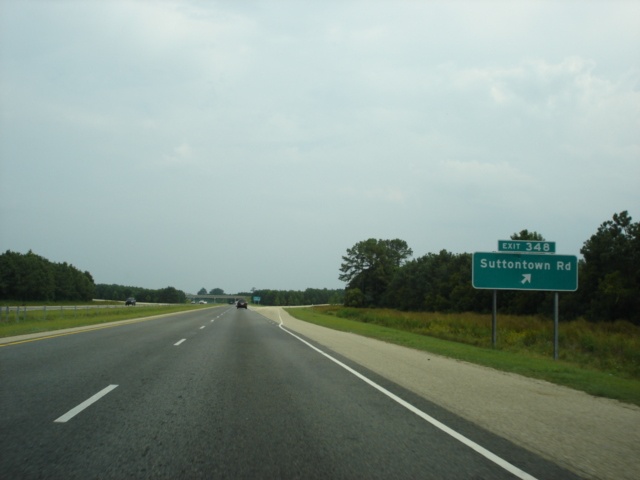 |
Interstate 40 East at Exit 348 - Suttontown Road. (Photo taken 7/6/05) |
 |
Interstate 40 East approaching Exit 355 - North Carolina 403 - 2 miles. Exit 355 is the final interchange inside Sampson County, as Interstate 40 enters Duplin County near mile marker 360. (Photo taken 7/6/05) |
 |
A four-lane divided highway connects North Carolina 403 just east of Interstate 40 to U.S. 117 six miles to the northeast of the interstate. The connector also has an interchange at North Carolina 50. Goldsboro is 25 miles north of Exit 355. (Photo taken 7/6/05) |
 |
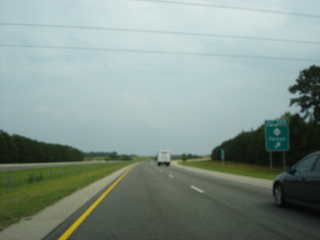
Interstate 40 East approaching Exit 355 - North Carolina 403 - 1 mile. The town of Faison (pop. 769) is three miles east of Exit 355. (Photo taken 7/6/05) |
 |
Just off of U.S. 117 between Faison and Goldsboro lies the town of Mount Olive, home of Mount Olive College, a Free Will Baptist institution. The town had a population of 4,474 according to a 2004 estimate by the U.S. Census Bureau. (Photo taken 7/6/05) |
 |
Interstate 40 East at Exit 355 - North Carolina 403 - Faison. We apologize for the blurriness. (Photo taken 7/6/05) |
 |
Interstate 40 East approaching Exit 364 - North Carolina 24 West/Business North Carolina 24 East/TO North Carolina 50 - 2 miles. North Carolina 24 was recently rerouted along Interstate 40 between exits 364 and 373 to bypass the towns of Warsaw and Kenansville. Warsaw is the largest city in Duplin County with a population of 3,085, but Kenansville is the seat of the county with a population of 878. (Photo taken 7/6/05) |
 |
The final rest area on Interstate 40 is located at Exit 364. (Photo taken 7/6/05) |
 |
Partially cut-off view of the one-mile advance signage for Exit 364. Business North Carolina 24 is four lanes between Interstate 40 and North Carolina 50 in Warsaw. (Photo taken 7/6/05) |
 |
One last reminder is given that a rest area is at Exit 364. (Photo taken 7/6/05) |
 |
Interstate 40 East at Exit 364 - North Carolina 24 West/Business North Carolina 24 East/TO North Carolina 50 - Warsaw. At the time of this photograph, this was the only eastbound exit between Interstate 95 and Wilmington with a sign bridge. Since Interstate 140 in Wilmington has been partially completed after we were here, that is likely no longer the case. (Photo taken 7/6/05) |
| Interstate 40 and North Carolina 24 East | |
 |
Interstate 40 and North Carolina 24 East assurance shields just past Exit 364. North Carolina 24 is a lengthy east-west state highway from Interstate 77 in north Charlotte to U.S. 70 in Morehead City. (Photo taken 7/6/05) |
 |
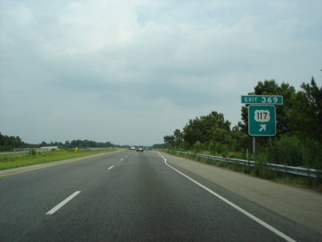
Interstate 40 and North Carolina 24 East approaching Exit 369 - U.S. 117 - 2 miles. U.S. 117 closely parallels Interstate 40 between Wilmington and Faison. The federal highway stays entirely within the borders of North Carolina from Wilmington to Wilson. (Photo taken 7/6/05) |
 |
Interstate 40 and North Carolina 24 East at Exit 369 - U.S. 117. No destination cities are given, since the cities that Interstate 40 and U.S. 117 serve from Faison to Wilmington are the same. (Photo taken 7/6/05) |
 |
Interstate 40 and North Carolina 24 East approaching Exit 373 - North Carolina 24 East/North Carolina 903 - 2 miles. North Carolina 903 is one of several crescent-shaped highways in the state. It begins at North Carolina 411 four miles east of Garland, heads northeast until reaching North Carolina 126 in Martin County, then turns to the northwest to the Virginia state line near Lake Gaston. (Photo taken 7/6/05) |
 |
Kenansville is home of James Sprunt Community College. Use North Carolina 903 and North Carolina 11 north. (Photo taken 7/6/05) |
 |
The city of Jacksonville, NC (pop. 72,335) is 44 miles to the east along North Carolina 24. The Camp Lejeune Marine Base makes its home there. (Photo taken 7/6/05) |
 |
Cowan Museum and Liberty Hall are two attractions located in Kenansville. (Photo taken 7/6/05) |
 |
Interstate 40 and North Carolina 24 East approaching Exit 373 - North Carolina 24 East/North Carolina 903 - 1 mile. Kenansville is five miles to the north of Exit 373. (Photo taken 7/6/05) |
 |
Interstate 40 and North Carolina 24 East at Exit 373 - North Carolina 24 East/North Carolina 903 - Magnolia/Kenansville. Magnolia is two miles to the southwest at the intersection of U.S. 117 and North Carolina 903. (Photo taken 7/6/05) |
| Interstate 40 East | |
 |
Interstate 40 East approaching Exit 380 - Charity Road - 2 miles. Charity Road is 5.7 miles long from Railroad Street in downtown Rose Hill to North Carolina 1953 in Greenevers. (Photo taken 7/6/05) |
 |
Interstate 40 East approaching Exit 380 - Charity Road - 1 mile. The exit is signed as simply Rose Hill. (Photo taken 7/6/05) |
 |
As somewhat mentioned above, use Charity Road eastbound to the town of Greenevers (pop. 581). (Photo taken 7/6/05) |
 |
Interstate 40 East at Exit 380 - Charity Road to Rose Hill and Greenevers. (Photo taken 7/6/05) |
 |
Interstate 40 East approaching Exit 384 - North Carolina 11 - 2 miles. North Carolina 11 begins at U.S. 74/U.S. 76 in Freeman and travels most of the length of the state to Business U.S. 158 in Murfreesboro. (Photo taken 7/6/05) |
 |
Interstate 40 East approaching Exit 384 - North Carolina 11 - 1 mile. (Photo taken 7/6/05) |
 |
Use North Carolina 11 south and North Carolina 1150 (High School Road) west to the small town of Teachey, population 250. (Photo taken 7/6/05) |
 |
The next three exits serve the town of Wallace. Located just north of the Duplin-Pender county line, Wallace is home to 3,521 residents, and is served by three highways; U.S. 117, North Carolina 11, and North Carolina 41. (Photo taken 7/6/05) |
 |
Interstate 40 East at Exit 384 - North Carolina 11. (Photo taken 7/6/05) |
 |
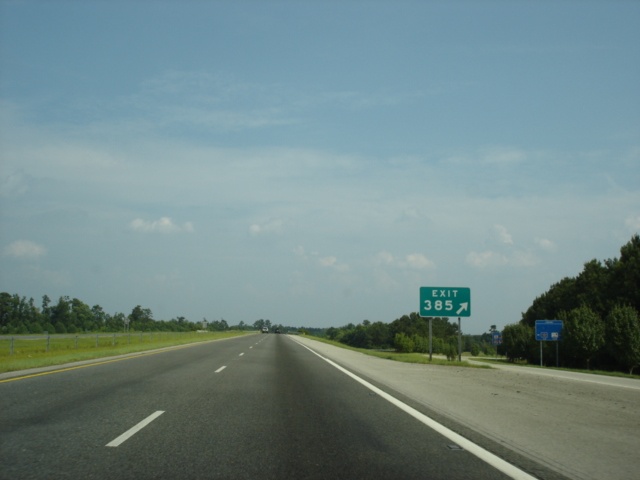
Interstate 40 East approaching Exit 385 - North Carolina 41 - 1 mile. This is the main Wallace exit. (Photo taken 7/6/05) |
 |
Interstate 40 East approaching Exit 385 - North Carolina 41 - 1/2 mile. North Carolina 41 is a north-south state highway that travels east-west in this area. It connects Fairmont, Lumberton, Elizabethtown, Wallace, and Trenton. (Photo taken 7/6/05) |
 |
Interstate 40 East at Exit 385 - North Carolina 41 - Wallace. No BGS was in place just prior to the exit so we snapped a picture of the gore point signage. (Photo taken 7/6/05) |
 |
Interstate 40 East approaching Exit 390 - U.S. 117 - 2 miles. Interstate 40 enters Pender County, also known as the "Blueberry Capital of the World," very shortly. (Photo taken 7/6/05) |
 |
Interstate 40 East approaching Exit 390 - U.S. 117 - 1 mile. As with the other U.S. 117 interchange (Exit 369), no destination cities are used. (Photo taken 7/6/05) |
 |
Interstate 40 East at Exit 390 - U.S. 117. A four mile backtrack to the north awaits those wanting to return to Wallace. (Photo taken 7/6/05) |
 |
Interstate 40 East approaching Exit 398 - North Carolina 53 - 2 miles. North Carolina 53 connects North Carolina 24 in Fayetteville to U.S. 258 and North Carolina 24 in Jacksonville. North Carolina 24 is the faster way between Fayetteville and Jacksonville. (Photo taken 7/6/05) |
 |
Use North Carolina 53 east and North Carolina 50 south to the Topsail Island beaches. (Photo taken 7/6/05) |
 |
The Pender campus of Cape Fear Community College is located in Burgaw. (Photo taken 7/6/05) |
 |
Interstate 40 East approaching Exit 398 - North Carolina 53 - 1 mile. (Photo taken 7/6/05) |
 |
Interstate 40 East at Exit 398 - North Carolina 53 - Burgaw/Jacksonville. A very rural 31 mile drive awaits those going to Jacksonville. (Photo taken 7/6/05) |
 |
Interstate 40 East approaching Exit 408 - North Carolina 210 - 2 miles. This is the second time that Interstate 40 travelers have seen the state highway, as they also meet at Exit 319. (Photo taken 7/6/05) |
 |
Hampstead is set along the U.S. 17/North Carolina 210 duplex and is 13.5 miles to the southeast. Rocky Point is located along U.S. 117 less than one mile to the west. (Photo taken 7/6/05) |
 |
Interstate 40 East approaching Exit 408 - North Carolina 210 - 1 mile. Topsail Island, which was mentioned back at Exit 398, is also mentioned here, even though Exit 398 is a better exit to use for the destination. (Photo taken 7/6/05) |
 |
Take North Carolina 210 west to Currie and the Moores Creek National Battlefield. (Photo taken 7/6/05) |
 |
Interstate 40 East at Exit 408 - North Carolina 210 - Topsail Island. (Photo taken 7/6/05) |
 |
Motorists are advised to stay on Interstate 40 East if the destination is Carolina Beach or Kure Beach. Both are located on U.S. 421 south of Wilmington. (Photo taken 7/6/05) |
 |
Interstate 40 East approaching Exit 414 - Holly Shelter Road to Castle Hayne and the Brunswick County Beaches - 2 miles. Castle Hayne is another stop along U.S. 117 near the Pender-New Hanover county line. Interstate 40 enters New Hanover County one mile to the north of Exit 414. (Photo taken 7/6/05) |
 |
Now in New Hanover County, we see the 3/4 mile advance signage for Exit 414. To the Brunswick County beaches, use Holly Shelter Road west and North Carolina 133 south. (Photo taken 7/6/05) |
 |
Interstate 40 East at Exit 414 - Holly Shelter Road - Castle Hayne/Brunswick County Beaches. There are just two more exits on Interstate 40 eastbound, one of which was not open yet at the time we were here. (Photo taken 7/6/05) |
 |
Interstate 40 East assurance shield just past Exit 414, with an extra twist; an "Ends 5 Miles" tab underneath the Interstate 40 shield. (Photo taken 7/6/05) |
 |
Interstate 140 will eventually connect to U.S. 17 on both sides of Wilmington and will serve as 3/4 of a loop of the city. The first section of the interstate opened on August 22, 2005, between North Carolina 133 and Interstate 40. (Photo taken 7/6/05) |
 |
A look at the then-future Interstate 140 overpass. It looked like both interstates will have collector/distributor ramps to ease the movements between the two. (Photo taken 7/6/05) |
 |
Interstate 40 East approaching Exit 420 - U.S. 117/North Carolina 132 North - 2 miles. This is the final interchange on Interstate 40 before the freeway transitions into U.S. 117 and North Carolina 132. (Photo taken 7/6/05) |
 |
Interstate 40 East approaching Exit 420 - U.S. 117/North Carolina 132 North - 1 mile. Gordon Road is an east-west road in north Wilmington between Kerr Avenue near the Wilmington International Airport and Military Cutoff Road just east of U.S. 17. (Photo taken 7/6/05) |
 |
Interstate 40 East at Exit 420 - U.S. 117/North Carolina 132 North - Gordon Road. A sign in the median tells motorists that continuing straight will bring them onto U.S. 117 and North Carolina 132 south. (Photo taken 7/6/05) |
 |
U.S. 117 and North Carolina 132 South assurance shields just past Exit 420 as the freeways transitions into a four-lane at-grade expressway. (Photo taken 7/6/05) |
 |
"End Freeway" sign as the first at-grade intersection past the eastern terminus of Interstate 40 quickly approaches. There is no "END Interstate 40" sign at the terminus, which is a bit disappointing. U.S. 117 and North Carolina 132 will meet U.S. 17 and U.S. 74 in 2.3 miles. U.S. 117 and North Carolina 132 are signed as College Road through Wilmington because the University of North Carolina at Wilmington is located on the arterial between U.S. 17/U.S. 74 and U.S. 76. (Photo taken 7/6/05) |
| Scenes Related to Interstate 40 | |
 |
North Carolina 96 North approaching Interstate 40. This is the first interchange south of Interstate 95. (Photo taken 7/6/05) |
 |
North Carolina 96 North at Interstate 40 East. Continuing straight will lead to Smithfield in 14 miles. (Photo taken 7/6/05) |
 |
U.S. 117 and North Carolina 132 South approaching Interstate 40 in north Wilmington. (Photo taken 7/6/05) |
 |
U.S. 117 and North Carolina 132 South at Interstate 40 West. One must use Gordon Road east for a short trek to get to Interstate 40 West, which begins at this interchange. On the opposite side of Gordon Road in the other direction is the Exit 420 off-ramp from Interstate 40 East. (Photo taken 7/6/05) |
Page created: November 19, 2005
Last updated:
November 20, 2005