OKRoads
Trip pages:
Day One:
Oklahoma: I-35
Texas: I-35 | I-35E | I-30 |
I-45
Day Two:
Texas: I-45
| I-10
Louisiana: I-10 |
I-12
Day Three:
Louisiana:
I-10 | I-55
Mississippi: I-55
Tennessee: I-55
Arkansas: I-55
Day Four:
Arkansas:
I-40
Oklahoma: I-40 |
I-240
State Highways
Terminus Gallery
Delaware State Highway
Terminus Gallery & Guides
Roadtrips:
2002
2003
2004
Other Pages
BAYOUS & BLUES
ROADTRIP
Interstate 10 Louisiana
Interstate 10 crosses the southern tier of the United States. It begins near the Pacific Ocean in Santa Monica, California, and ends at Interstate 95 in Jacksonville, Florida. On the second day of this roadtrip I drove Interstate 10 from Interstate 45 in Houston to Interstate 12 in Baton Rouge and from Slidell to downtown New Orleans. On the third day of the roadtrip I drove Interstate 10 from Slidell west to Interstate 55 near LaPlace.
Texas State Line to Interstate 12
Pictures taken December 17, 2002
 |
The first exit in Louisiana on Interstate 10 East is at Exit 4 - U.S. 90/LA 109 - Toomey/Sparks. |
 |
Interstate 10 East at Exit 7 - LA 3063 - Vinton. More construction in this area gave me an opportunity to get closer signage at 45 mph than I probably would've got at 70 mph. |
 |
Interstate 10 East at Exit 8 - LA 108 - Vinton. |
 |
Interstate 10 East at Exit 20 - Business LA 27 -Sulphur/Cameron. |
 |
Interstate 10 East at Exit 21 - LA 27 - DeQuincy. |
 |
Interstate 10 East at Exit 23 - LA 108 - Industries/ Sulphur. Lake Charles is just a couple miles away at this point. |
 |
Interstate 10 East approaching Exit 25 - Interstate 210 - 1 1/4 miles. Interstate 210 is Interstate 10's loop into Lake Charles. |
 |
Interstate 10 East approaching Exit 25 - 1/2 mile. |
 |
Interstate 10 East at Exit 25 - Interstate 210 East -Lake Charles Loop. |
 |
Interstate 10 East at Exit 26 - PPG Drive. |
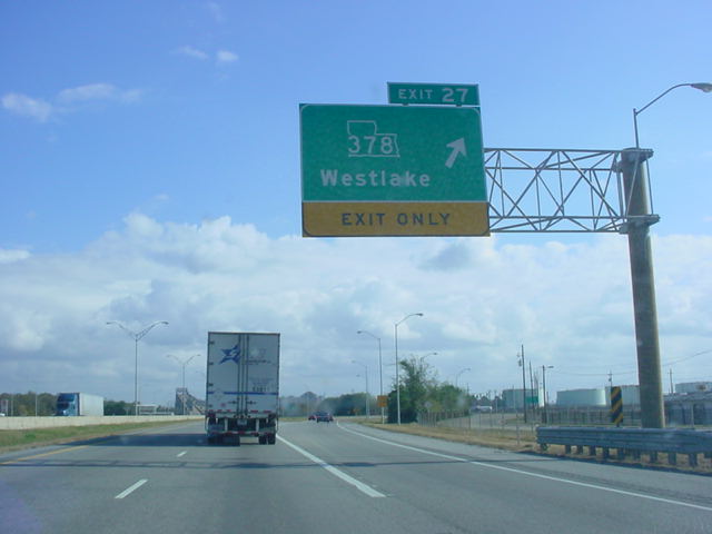 |
Interstate 10 East at Exit 27 - LA 378 - Westlake. |
 |
Interstate 10 East approaching Exit 29 - LA 385 - 2 miles. This gantry is at the west end of the approach to the bridge. |
 |
View of Lake Charles from the top of the bridge pictured above. |
 |
Interstate 10 East at Exit 29 - LA 385 - Downtown Area. |
 |
Interstate 10 East at Exit 31A - Business U.S. 90 -Enterprise Blvd. |
 |
Interstate 10 East at Exit 31B - U.S. 90 East TO LA 14. |
 |
Interstate 10 East at Exit 32 - Opelousas St. in Lake Charles. |
 |
Interstate 10 East at Exit 33 - U.S. 171 North -DeRidder/Shreveport. |
 |
Interstate 10 East approaching Exit 34 - Interstate 210 West - 1/2 mile. |
 |
Interstate 10 East at Exit 34 - Interstate 210 West. |
 |
Interstate 10 East at Exit 36 - LA 397 -Creole/ Cameron. |
 |
Interstate 10 East at Exit 43 - LA 383 - Iowa. |
 |
Interstate 10 East at Exit 44 - U.S. 165 - Alexandria. |
 |
Interstate 10 East at Exit 48 - LA 101 - Lacassine. |
 |
Interstate 10 East at Exit 54 - LA 99 - Welsh. |
 |
Interstate 10 East at Exit 59 - LA 395 - Roanoke. |
 |
Interstate 10 East at Exit 64 - LA 26 - Elton/Jennings. |
 |
Interstate 10 East at Exit 65 - LA 97 - Jennings/ Evangeline. |
 |
Interstate 10 East at Exit 72 - Egan. |
 |
Interstate 10 East at Exit 76 - LA
91 - Iota/ Estherwood. |
 |
Interstate 10 East at Exit 80 - LA 13 - Eunice/Crowley. |
 |
Interstate 10 East at Exit 87 - LA 35 - Church Point/Rayne. |
 |
Interstate 10 East at Exit 92 - LA 95 - Mire/Duson. |
 |
Interstate 10 East at Exit 97 - LA 93 - Cankton/Scott. |
 |
Interstate 10 East at Exit 100 - Ambassador Caffery Pkwy. |
 |
Interstate 10 East at Exit 101 -
LA 182 - Lafayette/ Carencro. |
 |
Interstate 10 East approaching Exits 103A-B - Interstate 49/U.S. 167 - 3/4 mile. |
 |
Interstate 10 East at Exit 103A - U.S. 167 South to U.S. 90 - Lafayette. |
 |
Interstate 10 East at Exit 103B - Interstate 49/U.S. 167 North - Opelousas. Interstate 49 currently finds its southern terminus here, but is slated to be extended down U.S. 167 and U.S. 90 to New Orleans. |
 |
Interstate 10 East at Exit 109 - LA 328 - Breaux Bridge. |
 |
Interstate 10 East at Exit 115 - LA
347 -Cecilla/ Henderson. This is the last exit before the 16-mile long bridge over the Atchafalaya Swamp area begins. |
 |
Interstate 10 East on the bridge over the swamplands. |
 |
Interstate 10 East as it crosses the Henderson Swamp on the same bridge. |
 |
Interstate 10 East at Exit
121 - Butte La Rose. This interchange is elevated over the same swamplands in the last couple pictures. |
 |
Interstate 10 East at Exit 127 - LA
975 - Whiskey Bay. This interchange is also located on the same viaduct. |
 |
Interstate 10 East at Exit 139 - LA
77 -Rosedale/ Grosse Tete. This is the first exit on solid ground since Exit 115. |
 |
Interstate 10 East at Exit 151 - LA 415/TO U.S. 190 -Lobdell. Notice the odd-looking LA 415 shield on this sign. It looks like Louisiana is scrunched into the sign slightly. |
 |
Interstate 10 East at Exit 153 - LA
1 - Port Allen/ Plaquemine. The bridge in the distance takes motorists over the Mississippi River and into Baton Rouge, the capital of Louisiana. |
 |
Interstate 10 East approaching Exit 155B - Interstate 110 - 2 miles. This sign gantry is on the approach to the Mississippi River bridge. |
 |
Interstate 10 East as it goes over the Mississippi River. |
 |
Interstate 10 East approaching Exit 155B - 1 mile. The city of Baton Rouge is also seen in this view from the top of the Mississippi River bridge. |
 |
Interstate 10 East at Exit 155A - LA 30 - To LSU/Nicholson Dr./Highland Rd. |
 |
Interstate 10 East approaching Exit 155B - 1/2 mile. |
 |
Interstate 10 East at Exit 155B - Interstate 110 North -Bus. District/Metro Airport. |
 |
Interstate 10 East at Exit 156A - Washington St. |
 |
Interstate 10 East at Exit 156B - Dalrymple Dr./LSU. |
 |
Interstate 10 East at Exit 157A - Perkins Rd. |
 |
Interstate 10 East at Exit 157B - Acadian Thwy. |
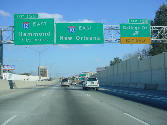 |
Interstate 10 East at Exit 158 - College Dr. |
 |
Interstate 10 East approaching Exit 159 - Interstate 12 East - 3/4 mile. Interstate 12 is an 85-mile alternate route for traffic traveling on Interstate 10 that doesn't want to travel through New Orleans. |
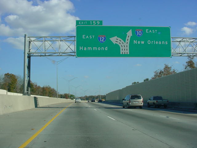 |
Interstate 10 East approaching Exit 159 - 1/2 mile. |
 |
Interstate 10 East at Exit 159 - Interstate 12 East. Interstate 10 heads southeast at this point as it makes its way towards New Orleans. Hammond is about 35 miles away from this interchange. |
Slidell to Interstate 55
Pictures taken December 18, 2002
 |
Interstate 10 West at Exit 263 -
LA 433 - Slidell. I accidentally had left the flash on from the night before so this picture looks a little weird. |
 |
Though partially cut off, the sign indicates that we are crossing over Lake Ponchatrain. The bridge is about six and a half miles long and it is the gateway into New Orleans. |
 |
View of Lake Ponchatrain from the bridge. |
 |
Interstate 10 West at Exit 254 - U.S. 11 - Irish Bayou/North Shore. |
 |
Interstate 10 West at Exit 248 - Michoud Blvd. |
 |
Interstate 10 West approaching Exits 246A-B - Interstate 510 South/LA 47 - 1 1/2 miles. |
 |
Interstate 10 West approaching Exits 246A-B - 3/4 mile. |
 |
Interstate 10 West approaching Exits 246A-B - 1/2 mile. |
 |
Interstate 10 West at Exits 246A-B - Interstate 510 South/LA 47 - Chalmette/Little Woods. |
 |
The split of Interstate 510 and LA 47 occurs here as seen from Interstate 10 West. |
 |
Interstate 10 West at Exit 245 - Bullard Ave. |
 |
Interstate 10 West at Exit 244 - Read Blvd. |
 |
Interstate 10 West at Exit 242 - Crowder Blvd. |
 |
Interstate 10 West at Exit 241 - Morrison Rd. |
 |
Interstate 10 West at Exit 240B - U.S. 90 East - Chef Hwy. |
 |
Interstate 10 West at Exit 239 - Louisa St. |
 |
Interstate 10 West approaching Exit 238B - Interstate 610 West - 3/4 mile. |
 |
Interstate 10 West at Exit 238A - Franklin Ave. |
 |
Interstate 10 West at Exit 238B - Interstate 610 West -N.O. Intl. Airport/Baton Rouge. |
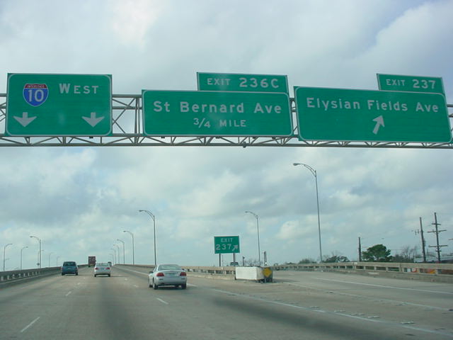 |
Interstate 10 West at Exit 237 - Elysian Fields Ave. |
 |
Interstate 10 West at Exit 236C - St. Bernard Ave. |
 |
Interstate 10 West at Exit 235A - Orleans Ave./Vieux Carre'. |
 |
Interstate 10 West at Exit 235B - Canal St./Superdome. |
 |
Interstate 10 West at Exit 232 - U.S. 61 - Tulane Ave./Carrollton Ave./Airline Dr. |
 |
Interstate 10 West at Exit 231B - Florida Blvd./West End Blvd. |
 |
Interstate 10 West at Exit 229 - Bonnabel Blvd. |
 |
Interstate 10 West at Exit 228 - Causeway Blvd./Mandeville. |
 |
Interstate 10 West at Exit 226 - Clearview Pkwy./Huey Long Br. |
 |
Interstate 10 West at Exit 225 - Veterans Blvd. |
 |
Interstate 10 West at Exit 224 - Power Blvd. |
 |
Interstate 10 West at Exit 223A - LA 49 - Williams Blvd./32nd St. |
 |
Interstate 10 West at Exit 223B - N.O. Intl. Airport. |
 |
Interstate 10 West at Exit 221 - Loyola Drive. The longest continuous viaduct in the world begins here and continues west with Interstate 10 for 10 miles before Interstate 55's first 23 miles take over the viaduct. The northern couple miles of Interstate 310 are on the same viaduct. |
 |
Interstate 10 West at Exit 220 - Interstate 310 -Boutte/Houma. This will eventually be the southern terminus of an extended Interstate 49. |
 |
Interstate 10 West approaching
Exit 210 - Interstate 55 North - 2 miles. We are still on the same viaduct that began at Exit 221! |
 |
Interstate 10 West at Exit 210 - Interstate 55 North -Hammond. The bridge is about to end for travelers staying on Interstate 10, however, for Interstate 55 North travelers there is still 23 more miles of this bridge left to go! |