OKRoads.com
Trip pages:
Note: All pages are for Texas highways unless otherwise specified.
Day One:
Interstate 35 Oklahoma |
Interstate 35 |
Interstate 35E
Day Two:
Interstate 35 |
U.S. 59 |
TX 44 |
TX 358 |
TX 286 |
Interstate 37
Day Three:
Interstate 35 |
U.S. 281 |
Interstate 410 |
Interstate 10 |
Interstate 45
Day Four:
Interstate 45 |
Interstate 30 |
Interstate 35E |
Interstate 35 |
Interstate 35 Oklahoma
Delaware State Highway
Terminus Gallery & Guides
2002
2003
2004
Seattle Trip
Coming soon!
Dairies & Lakes Roadtrip
Coming soon!
The Mystery Trip
Coming soon!
San Diego Trip
Coming soon!
Other Pages
SOUTH TEXAS ROADTRIP
Interstate 37
Interstate 37 is an intrastate interstate, connecting Corpus Christi and San Antonio. The interstate is 142 miles long. On Day Two of the South Texas Roadtrip, I drove all of Interstate 37.
U.S. 181 to Interstate 35
Pictures taken October 17, 2003
 |
Interstate 37 South at Exit 1A -
Buffalo St. Interstate 37 ends in about 1/2 mile. |
 |
Mile marker 0 on Interstate 37
South. The gantry ahead marks the southern ends of both U.S. 181 and Interstate 37. |
 |
Interstate 37 South at U.S. 181/TX
35 - Portland. The mainline will become Shoreline Blvd., which ends just ahead at the Corpus Christi Bay. |
 |
"Freeway Ends - 1/4 mile" sign as Interstate 37 South comes to an end. |
 |
Switching directions now, a view of
the beginning of Interstate 37 in Corpus Christi. The stoplight is the final one before the freeway begins. The exit ramp leads to U.S. 181 and TX 35. |
 |
Interstate 37 North approaching Exit
1B - Brownlee Blvd./Port Ave. - 1/4 mile, and Exit 1C - TX 286 - 1/2 mile. |
 |
Interstate 37 North at Exit 1B -
Brownlee Blvd./Port Ave. Most exit signs on Interstate 37 in the Corpus Christi area have been replaced in the past year. |
 |
Interstate 37 North at Exit 1C - TX
286 - Crosstown Expressway. |
 |
Interstate 37 North at Exit 1E -
Nueces Bay Blvd./Lawrence Dr. |
 |
The first standalone Interstate 37
North assurance shield, just past Exit 1E. |
 |
Interstate 37 North at Exit 2 - Up River Rd. |
 |
Interstate 37 North at Exit 3A -
Navigation Blvd. |
 |
Interstate 37 North at Exit 3B -
McBride Ln./Lantana St. |
 |
Interstate 37 North at Exit 4A - TX
358/ TX 44 - Padre Island. |
 |
Interstate 37 North at Exit 5 - Corn Products Rd./Valero Way. |
 |
Gore point signage at Exit 5. |
 |
Interstate 37 North at Exit 6 -
Southern Minerals Rd. |
 |
Interstate 37 North at Exit 7 -
Suntide Rd./Tuloso Rd. |
 |
Interstate 37 North at Exit 9 - FM
2292 - Up River Rd./Rand Morgan Rd. |
 |
Interstate 37 North at Exit 10 -
Carbon Plant Rd. |
 |
Interstate 37 North at Exit 11B -
Violet Rd./Hart Rd. |
 |
Interstate 37 North at Exit 13A - FM 1694 - Callicoatte Rd. |
 |
Interstate 37 North at Exit 13B - Sharpsburg Rd. |
 |
Interstate 37 North at Exit 14 -
U.S. 77 South - Robstown/Kingsville. |
 |
Interstate 37 North at Exit 16 -
Labonte Park. |
 |
Interstate 37 North at Exit 17 -
U.S. 77 - Sinton/Victoria. |
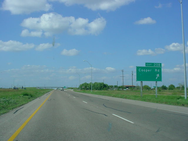 |
Interstate 37 North at Exit 20B -
Cooper Rd. |
 |
Interstate 37 North at Exit 31 - TX 188. |
 |
Interstate 37 North at Exit 34 -
Spur 459 - Mathis/Alice. |
 |
Interstate 37 North at Exit 36 - TX
359 - Mathis/Skidmore. |
 |
Interstate 37 North at Exit 40 - FM 888. |
 |
Interstate 37 North at Exit 47 - FM
534 - Swinney Switch. |
 |
Interstate 37 North at Exit 51 -
Hailey Ranch Rd. |
 |
Interstate 37 North at Exit 56 -
U.S. 59 - George West/Beeville. |
 |
Interstate 37 North at Exit 59 - FM
799. For some reason, the shield has been greened out. It was not greened out on the advance signage. |
 |
Interstate 37 North at Exit 65 - FM
1358 - Oakville. |
 |
Add another one to the funny-named parks list: this sign advertises the Choke Canyon State Park, accessible from Exit 69. Somehow, though, I didn't get a picture of the actual exit. |
 |
Interstate 37 North at Exit 72 -
U.S. 281 South. |
 |
Interstate 37 North at Exit 88 - FM
1099 - Campbellton. |
 |
Interstate 37 North at Exit 98 - FM
541 - McCoy/Poth. |
 |
Interstate 37 North at Exit 104 -
Spur 199 - Leal Rd. The spur is just located north of U.S. 281 (Exit 103); that is why the next exit following this one (104) is Exit 103. |
 |
Interstate 37 North at Exit 103 -
U.S. 281 North - Pleasanton. |
 |
Interstate 37 North at Exit 106 -
Coughran Rd. |
 |
Interstate 37 North at Exit 109 - TX
97 - Floresville. |
 |
Interstate 37 North at Exit 113 - FM 3006. |
 |
Interstate 37 North at Exit 117 - FM 536. |
 |
Interstate 37 North at Exit 120 - Hardy Rd. |
 |
Interstate 37 North at Exit 122 -
Priest Rd./Mathis Rd. |
 |
Interstate 37 North at Exit 125 -
Loop 1604 - Anderson Loop/Elmendorf. |
 |
Interstate 37 North at Exit 127 -
San Antonio River Turnaround. |
 |
Interstate 37 North at Exit 130 -
Donop Rd./Southton Rd. |
 |
Interstate 37 North approaching Exit 133 - Interstate 410/U.S. 281 South - 1 1/2 miles. |
 |
Interstate 37 North at Exit 132 -
Spur 122. |
 |
Interstate 37 North approaching Exit 133 - Next Right. |
 |
Interstate 37 North approaching Exit 133 - 1/4 mile. |
 |
Interstate 37 North at Exit 133 -
Interstate 410/U.S. 281 South. |
 |
Interstate 37 North at Exit 135 -
Loop 13 - Military Dr./Brooks City-Base. |
 |
Interstate 37 North at Exit 136 -
Pecan Valley Dr. |
 |
Interstate 37 North at Exit 137 -
Hot Wells Blvd. |
 |
Interstate 37 North at Exit 138A-B - Southcross Blvd./New Braunfels Ave. Interstate 10 is 1 3/4 miles ahead. |
 |
Interstate 37 North at Exit 138C -
Fair Ave. |
 |
Interstate 37 North approaching Exit 139 - Interstate 10/U.S. 90/U.S. 87 - 1/4 mile. |
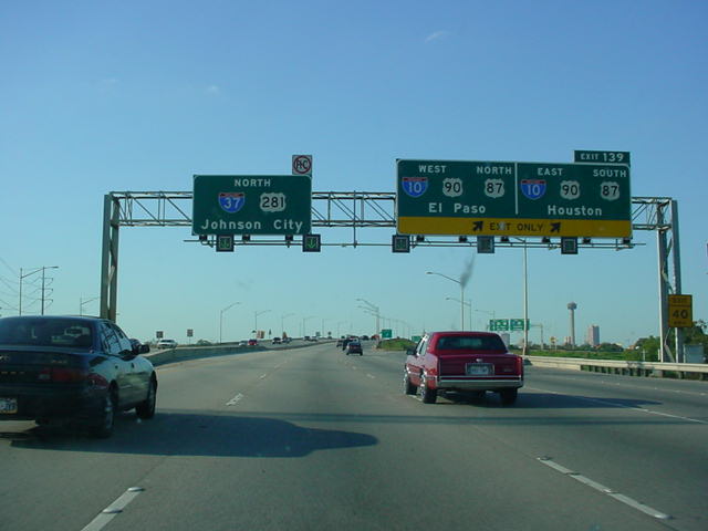 |
Interstate 37 North at Exit 139 -
Interstate 10/U.S. 90/U.S. 87 - El Paso/Houston. |
 |
Interstate 37 North at Exit 140A -
Carolina St./Florida St. The Alamodome is visible just ahead. |
 |
Interstate 37 North approaching Exit 142A - Interstate 35 North - 2 1/4 miles, and Exit 142B - Interstate 35 South - 2 1/2 miles. |
 |
Interstate 37 North at Exit 140B - Durango Blvd./Alamodome. |
 |
Interstate 37 North at Exit 141 - Commerce St./Downtown/The Alamo. Interstate 35 is now 1 1/4 miles ahead. |
 |
Interstate 37 North approaching Exit 142A - 1/2 mile, and Exit 142B - 3/4 mile. |
 |
Interstate 37 North approaching Exit 142A - 1/4 mile, and Exit 142B - 1/2 mile. |
 |
Interstate 37 North approaching Exit 142A - 1/8 mile, and Exit 142B - 1/4 mile. |
 |
Interstate 37 North at Exit 142A - Interstate 35 North - Austin. Exit 142B for Interstate 35 South - Laredo is just ahead. (However, again, I ran out of disk space with this picture, so I didn't get a pic of that exit) |